2010 Indiana earthquake
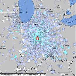
 Map of the maximum intensity in the surrounding counties with a star as the epicenter. | |
| Date | 12:55:21, December 30, 2010 |
|---|---|
| Magnitude | 3.8 |
| Depth | 3 mi (4.83 km) |
| Epicenter | 40°25′37″N 85°53′17″W / 40.427°N 85.888°WCoordinates: 40°25′37″N 85°53′17″W / 40.427°N 85.888°W |
| Areas affected |
United States Indiana |
| Max. intensity | V (Moderate, Mercalli) |
| Tsunami | None |
| Landslides | None |
The 2010 Indiana earthquake registered 3.8 on the moment magnitude scale and struck near Greentown and Kokomo on December 30, 2010 at 12:55:21 UTC at a depth of 3 mi.[1][2] The quake occurred approximately 50 miles north of Indiana's capital, Indianapolis.[1] It joins only three other earthquakes that have affected the northern Indiana area since 1999.[3] The “extremely rare and unprecedented” earthquake had the largest magnitude of a northern Indiana earthquake in 175 years.[4] Despite being considered a rare occurrence, the affected region of northern Indiana lies near many fault lines including the Wabash Valley Seismic Zone and the New Madrid Seismic Zone.[5][6] Both zones are hotspots for tectonic activity, with the Wabash Valley Fault Zone reaching earthquake depths up to 18 km (11.4 mi.) deep.[7] It was incorrectly recorded by nearby stations as a 4.2 magnitude before being downgraded to 3.8.[8] No significant damages were reported from the incident, but the quake was felt by thousands, spanning across multiple cities and states.[9] Towns as far away as Kalamazoo, Michigan and states as far as Wisconsin and Kentucky reported the earthquake.[10][11]
References
- 1 2 "Magnitude 3.8 - INDIANA". USGS. Retrieved May 13, 2011.
- ↑ Silverleib, Alan (December 30, 2010). "Indiana earthquake: a 'very loud boom'". CNN. Retrieved December 12, 2012.
- ↑ Guarino, Mark. "Illinois earthquake third to rattle upper Midwest since 1999". Christian Science Monitor. ISSN 0882-7729. Retrieved 2016-02-02.
- ↑ Mark Guarino (December 30, 2010). "Indiana earthquake 'extremely rare and unprecedented'". The Christian Science Monitor. Retrieved May 14, 2011.
- ↑ Blake, Brian. "Wabash Valley Seismic Zone". www.cusec.org. Retrieved 2016-02-02.
- ↑ Blake, Brian. "New Madrid Seismic Zone". www.cusec.org. Retrieved 2016-02-02.
- ↑ Kim, WY (October 2003). "The 18 June 2002 Caborn, Indiana, earthquake: Reactivation of ancient rift in the Wabash Valley seismic zone?". Web of Science. Retrieved February 1, 2016.
- ↑ "Indiana earthquake downgraded to 3.8 on Richter scale". Catholic Online. December 30, 2010. Retrieved December 12, 2012.
- ↑ "Small quake a boon for geologists -- Daily Herald". prev.dailyherald.com. Retrieved 2016-02-02.
- ↑ Fusciardi, Chris (December 30, 2010). "Indiana earthquake 'absolutely unmistakable' to some Southwest Michigan residents". Michigan Live. Retrieved December 12, 2012.
- ↑ Mary Collins; Nicole Hahn; John W. Davis (December 30, 2010). "Did You Feel That Earthquake?". Indiana News Center. Retrieved December 12, 2012.