Aïn Defla Province
| Aïn Defla Province ولاية عين الدفلى | |
|---|---|
| Province | |
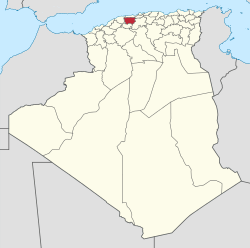
 Map of Algeria highlighting Aïn Defla | |
| Coordinates: 36°19′N 2°10′E / 36.317°N 2.167°ECoordinates: 36°19′N 2°10′E / 36.317°N 2.167°E | |
| Country |
|
| Capital | Aïn Defla |
| Government | |
| • PPA president | Mr. Menad Mehdi (FLN) |
| • Wāli | Mr. Tikhmarine Lakhdar |
| Area | |
| • Total | 4,897 km2 (1,891 sq mi) |
| Population (2008)[1] | |
| • Total | 771,890 |
| • Density | 160/km2 (410/sq mi) |
| Time zone | CET (UTC+01) |
| Area Code | +213 (0) 27 |
| ISO 3166 code | DZ-44 |
| Districts | 14 |
| Municipalities | 36 |
Aïn Defla (Arabic: ولاية عين الدفلى) is a wilaya (province) in northern Algeria. It is located to the southwest of Algiers, the capital. Localities in Ain Delfa include Khemis Miliana, Miliana, Hammam Righa, Oued Zebboudj and Aïn Torki.
Administrative divisions
It is made up of 14 districts and 36 municipalities.
The districts are:
The municipalities are:
- Aïn Bénian
- Aïn Bouyahia
- Aïn Defla
- Aïn Lechiakh
- Aïn Soltane
- Aïn Torki
- Arib
- Barbouche
- Bathia
- Bellas
- Ben Allal
- Bir Ould Khelifa
- Bordj Emir Khaled Chikh
- Bouchared
- Boumedfaa
- Djelida
- Djemaa Ouled
- Djendel
- El Abadia
- El Amra
- El Attaf
- El Hassania
- El Maine
- Hammam Righa
- Hoceinia
- Khemis Miliana
- Mekhatria
- Miliana
- Oued Chorfa
- Oued Djemaa
- Rouina
- Sidi Lakhdar
- Tacheta Zougagha
- Tarik Ibn Ziad
- Tiberkanine
- Zeddine
References
- ↑ Office National des Statistiques, Recensement General de la Population et de l’Habitat 2008 Archived July 24, 2008, at the Wayback Machine. Preliminary results of the 2008 population census. Accessed on 2008-07-02.
This article is issued from Wikipedia - version of the 11/13/2016. The text is available under the Creative Commons Attribution/Share Alike but additional terms may apply for the media files.