Ali Sabieh Region
| Ali Sabieh | |
|---|---|
| Region | |
 | |
| Country |
|
| Capital | Ali Sabieh |
| Area | |
| • Total | 2,400 km2 (900 sq mi) |
| Population (2010) | |
| • Total | 71,640 |
| • Density | 30/km2 (77/sq mi) |
| ISO 3166 code | DJ-AS |
Ali Sabieh Region (Somali: Gobolka Cali Sabiix) is a region in southern Djibouti. With a mainland area of 2,400 square kilometres (900 sq mi), it lies along the national border with Somalia and Ethiopia. Its capital is Ali Sabieh. The Arrei Mountains are the highest point in the region.
History
Nomadic life in the Ali Sabieh Region dates back at least 2,000 years. During the Middle Ages, the Ali Sabieh Region was ruled by the Ifat Sultanate and the Adal Sultanate. It later formed a part of the French Somaliland protectorate in the first half of the 20th century.
Overview
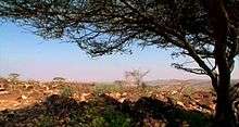
The region borders Arta Region to the north, the Dikhil Region to the west, and the nation of Somalia to the east, and the nation of Ethiopia to the south. Largely arid, the Ali Sabieh Region is noted for its bare plains of Grand Bara and its large Mountains. The Ali Sabieh region has old forts all round the region build by the French Army in the 20th century.
The inhabitants of the Ali Sabieh region belong mainly to the people of Issa Somali clan.
The local commercial sector is centered on construction (cement) and storage of goods in transit to Ethiopia. Towns in the region have experienced significant growth with the increasing industrialization. The area has also seen some investment.
Geography
Ali Sabieh is the fourth largest Region in the country. It contains around 16.5% of the nation's landmass. The Arta lies to the north, and Dikhil to the west. Ali Sabieh Region also shares a border with the Somali Region of Ethiopia to the south, and the Awdal of Somalia to the east. Ali Sabieh's highest point is Arrei, which has an elevation of 4,268 ft (1,301 m). Other mountain ranges in the Region include the Boura Mountains, the Arrei Mountains, the Rahle Godle, and the Dagouein Mountain. Ali Sabieh Region has an extraordinarily diverse geography. The western half of the region is part of the coastal plain and has an exceedingly hot, humid and arid climate. The eastern half, however, is very mountainous, with the major peak being 1,301-metre-high Arrei Mountain, near Guelile. These mountains trap the moisture created by an upper-level wind reversal between May and October, so that in the eastern half of the region annual rainfall increases from 100 millimetres in the foothills to probably more than 250 millimetres. The main wadis that cross are the wadis Dey Dey, Holl-Holl, Beye-Adey, Danan and Guestir.
Climate
The Ali Sabieh Region has cold winters than the highlands, while the lowlands has mild winters. The region elevation is the major factor in temperature levels, with the higher areas, on average, as 11°C (20°F) cooler, day or night. The overnight lows are not like the "Garden of Eden" because, at night, heavy clothes or blankets are needed, in the highlands, when the temperature drops to about 50–54 °F (10–12.2 °C) every night. Ali Sabieh Region has much variation in its climate. Climate in Ali Sabieh Region can be hot, although extended periods over 100 °F (38 °C) for the maximum temperature are rare, except for the lowest point in elevation. Hot summer days are tempered by the low relative humidity and cooler evenings during summer months since, for most of the state, the highest diurnal difference in temperature is often in the summer.
The annual mean statistics for some Ali Sabieh Region centres is shown below:
| Town | Min. Temp | Max. Temp | Rainfall |
|---|---|---|---|
| Ali Sabieh | 16.4 °C (61.5 °F) | 37.4 °C (99.3 °F) | 191 mm (7.5 in) |
| Dasbiyo | 16.9 °C (62.4 °F) | 38.0 °C (100.4 °F) | 174 mm (6.9 in) |
| Holhol | 18.0 °C (64.4 °F) | 39.0 °C (102.2 °F) | 195 mm (7.7 in) |
Towns
| Town names | Population |
|---|---|
| Ali Sabieh | 55,000 |
| Holhol | 3,519 |
| Dasbiyo | 700 |
| Ali Adde | 3,123 |
| Goubetto | 1,400 |
| Assamo | 500 |
| Anaba | 210 |
| Guelile | 567 |
| Guisti | 500 |
| Dânan | 301 |
| Doudoub Bolole | 200 |
References
- "Djibouti". World Factbook. Central Intelligence Agency. 2007-09-06. Archived from the original on 11 September 2007. Retrieved 2007-09-18.
Coordinates: 11°08′N 42°43′E / 11.133°N 42.717°E