Alnes Lighthouse
 | |
 Møre og Romsdal | |
| Location |
Alnes Giske Norway |
|---|---|
| Coordinates | 62°29′23.8″N 05°58′02.0″E / 62.489944°N 5.967222°ECoordinates: 62°29′23.8″N 05°58′02.0″E / 62.489944°N 5.967222°E |
| Year first constructed | 1853 (first) |
| Year first lit | 1876 (current) |
| Automated | 1982 |
| Construction | wooden tower |
| Tower shape | square frustum tower with balcony and lantern |
| Markings / pattern | white tower with two horizontal red bands, white balcony, red lantern |
| Height | 26.5 m (87 ft) |
| Focal height | 36 m (118 ft) |
| Light source | mains power |
| Intensity | 25,900 cd |
| Range | 16.4 nmi (30.4 km; 18.9 mi) |
| Characteristic | Oc (2) WRG 8s. |
| Admiralty number | L0832 |
| NGA number | 6192 |
| ARLHS number | NOR-299 |
| Norway number | NF-3387[1] |
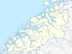
Alnes lighthouse was established in 1852 to guide fishing boats safely to the harbor of the small fishing community of Alnes on Godøy island on the west coast of Norway. It is located on the north side of Godøy island in the municipality of Giske in Møre og Romsdal county, about 4 kilometres (2.5 mi) northwest of Leitebakk.
History
The current lighthouse was built in 1876 and is still in operation with a few modifications.[2]
The lighthouse was automated in 1982 and is now owned by the municipality of Giske. The galley and the tower are open for tourists from May through October, and the old keeper's house has a café and an exhibition hall where artwork from local artists are displayed. There is also a small historical museum inside the lighthouse tower. Only a 30-minute drive from Ålesund, it is easily accessible for visitors and is one of the most visited lighthouses in Norway.
See also
References
- ↑ Rowlett, Russ. "Lighthouses of Norway: Ålesund Area". The Lighthouse Directory. University of North Carolina at Chapel Hill. Retrieved February 26, 2016.
- ↑ Store norske leksikon. "Alnes fyr" (in Norwegian). Retrieved 2010-09-26.

External links
| Wikimedia Commons has media related to Alnes fyr. |
- Norsk Fyrhistorisk Forening (Norwegian)