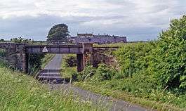
Auchincruive railway station
| Auchincruive | |
|---|---|
|
Station site (1994) | |
| Location | |
| Place | Auchincruive |
| Area | Ayrshire |
| Operations | |
| Pre-grouping | Glasgow and South Western Railway |
| Platforms | 2 |
| History | |
| 1 September 1870 | Opened |
| 10 September 1951 | Closed |
| Disused railway stations in the United Kingdom | |
|
Closed railway stations in Britain A B C D–F G H–J K–L M–O P–R S T–V W–Z | |
|
| |
Auchincruive railway station was a railway station serving the settlement of St Quivox and the estate of Auchincruive, South Ayrshire, Scotland. The station was originally part of the Ayr to Mauchline Branch of the Glasgow and South Western Railway.
History
The station opened on 1 September 1870,[1] The station was part of the Ayr to Mauchline Branch of the Glasgow and South Western Railway. It became part of the London Midland and Scottish Railway during the Grouping of 1923. Passing on to the Scottish Region of British Railways during the nationalisation of 1948 who closed the station to regular passenger services on 10 September 1951.[1]
The site today
Today the Ayr to Mauchline line is still open as a freight line.
References
Notes
Sources
- Butt, R. V. J. (1995). The Directory of Railway Stations: details every public and private passenger station, halt, platform and stopping place, past and present (1st ed.). Sparkford: Patrick Stephens Ltd. ISBN 1-8526-0508-1. OCLC 60251199.
- Jowett, Alan (2000). Jowett's Nationalised Railway Atlas (1st ed.). Penryn, Cornwall: Atlantic Transport Publishers. ISBN 0-9068-9999-0. OCLC 228266687.
- Jowett, Alan (March 1989). Jowett's Railway Atlas of Great Britain and Ireland: From Pre-Grouping to the Present Day (1st ed.). Sparkford: Patrick Stephens Ltd. ISBN 1-8526-0086-1. OCLC 22311137.
- Station on navigable O.S. map (disused station near St Quivox)
| Preceding station | Historical railways | Following station | ||
|---|---|---|---|---|
| Ayr Line and station open |
Glasgow and South Western Railway Ayr to Mauchline Branch |
Annbank Line open; station closed | ||
Coordinates: 55°28′59″N 4°34′36″W / 55.48301°N 4.57656°W
