 |
Denmark |
|
 |
(1) |
Ellund border crossing |
 |
 |
Services Ellund  |
 |
(2) |
Flensburg / Harrislee  |
.png) |
|
Rest area Handewitter Forst/Altholzkrug |
 | |
100 m |
 |
(3) |
Flensburg  |
 | |
Treenetalbrücke 200 m |
 |
(4) |
Tarp |
.png) |
|
Rest area Jalmer Moor/Jalm |
.png) |
|
Rest area Arenholz  |
 |
(5) |
Schleswig / Schuby  |
.png) |
|
Rest area Husby  |
 |
(6) |
Schleswig / Jagel  |
.png) |
|
Rest area Moor/Lottorf |
 |
(7) |
Owschlag |
 |
 |
Services Hüttener Berge |
 |
(8) |
Rendsburg / Büdelsdorf  |
 | |
Europabrücke 1.498 m |
 |
|
Rade parking area |
 |
(9) |
Rendsburg 4-way interchange  |
.png) |
|
Rest area Ohe |
 |
(10) |
Warder |
.png) |
|
Rest area Brahmsee/Dätgen |
 |
(11) |
Bordesholm |
|
|

|
6-streifiger Ausbau bis Hamburg-Nordwest |
 |
 |
3-way interchange Bordesholm  |
 |
 |
Neumünster-Nord (under construction)  |
  |
 |
Rest area Aalbek (under construction)  |
 |
 |
Neumünster-Mitte (under construction)  |
 |
 |
Neumünster-Süd (under construction)   |
  |
 |
Rest area Brokenlande (under construction) |
 |
 |
Großenaspe (under construction) |
 |
 |
Biemölen/Sielsbrook |
 |
 |
Bad Bramstedt (under construction)  |
 |
|
Kreuz Schmalfeld (planned)  |
 |
 |
Schmalfeld  |
 |
 |
Schmalfeld  |
 |
 |
Kaltenkirchen (under construction) |
 |
 |
Moorkaten |
 |
 |
Henstedt-Ulzburg (under construction)   |
 |
 |
Beckershof   |
 |
|
Ellerau (planned) |
 |
 |
Quickborn (under construction) |
  |
 |
Rest area Holmmoor (under construction) |
 |
|
Norderstedt-Mitte (planned) |
 |
 |
Bönningstedt |
 |
 |
Hamburg-Schnelsen Nord (under construction) (Airport)  |
 |
 |
Hamburg-Schnelsen (under construction)  |
|
 |
(25) |
Hamburg-Nordwest 3-way interchange  |
 |
(26) |
Hamburg-Stellingen   |
 |
(27) |
Hamburg-Volkspark |
 |
|
Tunnel Überdeckelung Altona 3000 m (planned) |
 |
(28) |
Hamburg-Bahrenfeld  |
 |
(29) |
Hamburg-Othmarschen |
 | |
Elbtunnel |
 |
|
3-way interchange HH-Hafen (planned)  |
 | |
Hochstraße Elbmarsch 4.359 m |
 |
(30) |
Hamburg-Waltershof  |
 |
(31) |
Hamburg-Moorburg |
 |
(32) |
Hamburg-Heimfeld  |
 |
(33) |
Hamburg Südwest 3-way interchange  |
 |
(34) |
Hamburg-Marmstorf / Buchholz  |
 |
 |
Services Harburger Berge |
 |
(35) |
Fleestedt  |
 |
(36) |
Maschener Kreuz  , ,  |
 |
(37) |
Horster Dreieck  |
 |
 |
Services Seevetal  |
 |
(38) |
Seevetal - Ramelsloh |
 |
 |
Services Hasselhöhe  |
 |
(39) |
Thieshope |
 |
|
Eichberg parking area  |
 |
|
Utspann parking area  |
 |
(40) |
Garlstorf |
.png) |
|
Rest area Garlstorfer Wald/Schaabbskaben |
 |
|
3-way interchange Egestorf (planned)  |
 |
(42) |
Evendorf |
 |
|
Auegrund parking area  |
 |
|
Vorm Naturschutzpark parking area  |
 |
 |
Services Brunautal |
 |
(43) |
Bispingen |
 |
|
Bispinger Tor parking area  |
 |
|
Timmerloh parking area  |
 |
|
Am Stühbeckshorn parking area  |
 |
|
Bei den Schnellbergen parking area  |
 |
(44) |
Soltau-Ost   |
.png) |
|
Rest area Abelbeck  |
 |
 |
Services Vorm Wietzenbruch  |
 |
(45) |
Soltau-Süd   |
.png) |
|
Rest area Dorfmark  |
 |
(46) |
Dorfmark  |
 |
|
parking area |
 |
(47) |
Fallingbostel  |
.png) |
|
Rest area Wolfsgrund |
 |
(48) |
Dreieck Walsrode 3-way interchange  |
 |
(49) |
Westenholz |
 |
 |
Services Allertal (includes junction) |
 | |
Allerbrücke 200 m |
 |
(50) |
Schwarmstedt   |
 |
(51) |
Berkhof |
 |
(52) |
Mellendorf  |
 |
(53) |
Hannover-Nord 3-way interchange  |
.png) |
|
Rest area |
 |
(54) |
Großburgwedel |
 |
(55) |
Altwarmbüchen |
 |
(56) |
Hannover / Kirchhorst 4-way interchange  |
.png) |
|
Rest area |
 |
(57) |
Kreuz Hannover-Ost 4-way interchange  |
 |
(58) |
Hannover-Anderten  |
 | |
Mittellandkanalbrücke |
 |
 |
Services Wülferode |
 |
(59) |
Laatzen  |
 |
(60) |
Hannover-Süd 3-way interchange  |
.png) |
|
Rest area |
 | |
Brücke Stichkanal Hildesheim |
 |
(61) |
Hildesheim-Drispenstedt  |
 |
(62) |
Hildesheim  |
 |
|
parking area  |
 |
 |
Services Hildesheimer Börde |
 | |
Talbrücke 100 m |
 |
(63) |
Derneburg / Salzgitter  |
 |
(64) |
Dreieck Salzgitter 3-way interchange  |
.png) |
|
Rest area Sillium |
 |
(65) |
Bockenem   |
|
|

|
8-streifiger Ausbau bis Herbst 2015 |
 |
 |
Bornum am Harz/? |
 |
 |
Rhüden (under construction)   |
  |
 |
Rest area Harz (under construction) |
|
 |
(67) |
Seesen  |
 |
 |
Services Seesen |
 |
|
parking area  |
 |
(68) |
Echte  |
.png) |
|
Rest area Kalefeld |
 |
(69) |
Northeim-Nord   |
 | |
Flutbrücke Northeim300 m |
 | |
Leinebrücke75 m |
 |
(70) |
Northeim-West  |
 |
(71) |
Nörten-Hardenberg  |
.png) |
|
Rest area Parensen |
 |
(72) |
Göttingen-Nord |
 |
(73) |
Göttingen  |
 |
 |
Services Göttingen (includes junction) |
 |
(74) |
Drammetal 3-way interchange  |
.png) |
|
Rest area Heckelberg/Hedemünden |
 |
(75) |
Hann. Münden / Hedemünden |
 | |
Werratalbrücke 422 m |
.png) |
|
Rest area Hann. Münden-Humboldtblick  |
 |
(76) |
Hann. Münden / Lutterberg  |
.png) |
|
Rest area Staufenberg  |
.png) |
|
Rest area Herkulesblick  |
 | |
Niestebrücke 200 m |
 |
(77) |
Kassel-Nord  |
 |
(78) |
Kassel-Ost  |
 |
|
3-way interchange Lossetaldrieck (planned)  |
 | |
Lossetalbrücke 200 m |
 |
(79) |
Kassel-Mitte 4-way interchange  |
 |
 |
Services Kassel (includes junction) |
 |
(80) |
Dreieck Kassel-Süd 3-way interchange  |
 |
(81) |
Guxhagen |
.png) |
|
Rest area Markwald/Quillerwald |
 | |
Brückenbachtalbrücke 100 m |
 |
(82) |
Melsungen  |
 |
(83) |
Malsfeld  |
 |
 |
Services Hasselberg |
 |
(84) |
Homberg (Efze)  |
 |
|
Raboldshausen parking area  |
.png) |
|
Rest area Am Pommer  |
 |
(85) |
Bad Hersfeld-West  |
 |
(86) |
Kirchheimer Dreieck  |
 |
 |
Raststätte Kirchheim (abolished) |
 |
(87) |
Kirchheim   |
 |
|
Autobahnkirche Kirchheim/Hesse |
 | |
Aulatalbrücke 200 m |
 |
(88) |
Hattenbacher Dreieck  |
 |
|
Strampen/Ottersbach parking area |
 |
(89) |
Niederaula  |
 | |
Fuldabrücke |
 |
|
Dornbusch/Richtgraben parking area |
 |
 |
Services Großenmoor |
 |
|
Mahlertshof parking area  |
 |
(90) |
Hünfeld / Schlitz |
 |
|
Fuchsberg/Rotkopf parking area |
 |
|
Hummelskopf/Geißhecke parking area |
 |
(91) |
Fulda-Nord   |
 |
|
Rauschenberg/Petersberg parking area |
 |
(92) |
Fulda-Mitte  |
 |
|
Röther Tannen parking area  |
 |
|
Pilgerzell parking area  |
 |
|
Eichenzell parking area  |
 |
(93) |
Fulda-Süd / Dreieck Fulda  |
 | |
Fuldabrücke 932 m |
 |
|
Steinhauk/Riederberg parking area |
 |
|
Steinborntal parking area  |
 | |
Thalaubachtalbrücke ca. 400 m |
 |
|
Lohmühle parking area  |
 | |
Döllbachtalbrücke ca. 600 m |
 |
 |
Services Uttrichshausen |
 | |
Talbrücke Uttrichshausen 870 m |
 |
|
Röhneiche parking area  |
 |
|
Forsthaus parking area  |
 | |
Grenzwaldbrücke 965 m |
 |
|
parking area  |
 |
(94) |
Bad Brückenau-Volkers  |
 |
|
parking area  |
 |
|
parking area |
 | |
Römershagbrücke 313 m |
 | |
Sinntalbrücke 810 m |
 |
|
parking area  |
 |
(95) |
Bad Brückenau / Wildflecken  |
 |
|
parking area  |
 |
 |
Services Rhön |
 |
|
parking area  |
 |
|
parking area |
 |
(96) |
Bad Kissingen / Oberthulba |
 | |
Thulbabrücke 493 m |
 |
|
parking area  |
 | |
Fränkische-Saale-Brücke 372 m |
 | |
Brücke 150 m |
 |
(97) |
Hammelburg  |
 | |
Klöffelsbergbrücke 367 m |
 |
|
parking area  |
 |
|
parking area |
 |
|
parking area |
 |
(98) |
Schweinfurt / Niederwerrn  |
 |
|
parking area  |
 |
(99) |
Schweinfurt / Werneck 4-way interchange   |
 | |
Stettbachbrücke 249 m |
 |
|
parking area  |
 | |
Schraudenbachbrücke 249 m |
 |
|
parking area |
 | |
Werntalbrücke 482 m |
 |
  |
Services / Motel Riedener Wald |
 |
|
parking area  |
 |
|
parking area  |
 |
(100) |
Gramschatzer Wald  |
 |
|
parking area |
 |
|
parking area  |
 | |
Pleichachtalbrücke 375 m |
 |
(101) |
Würzburg / Estenfeld  |
 | |
Kürnachtalbrücke 375 m |
 |
|
parking area |
 |
|
parking area  |
 | |
Rothofbrücke 440 m |
 |
|
parking area  |
 |
(102) |
Biebelried 4-way interchange  |
 |
(103) |
Kitzingen  |
 | |
Talbrücke Kaltensondheim 155 m |
.png) |
|
Rest area |
 | |
Mainbrücke Marktbreit 928 m |
 | |
Bräubachtalbrücke 247 m |
 |
(104) |
Marktbreit |
|
|

|
8-streifiger Ausbau bis 2015 |
 |
 |
' |
 |
 |
Gollhofen (under construction)   |
 |
 |
Uffenheim / Langensteinach (under construction) |
  |
 |
Rest area Ohrenbach (under construction) |
 |
 |
Bad Windsheim (under construction)  |
 |
 |
Enstalbrücke 181 m |
 |
 |
Rothenburg ob der Tauber (under construction) |
 |
 |
' |
 |
 |
Talbrücke Wolfsau 344 m |
 |
 |
Talbrücke Pfeffermühle 406 m |
|
 |
(109) |
Wörnitz  |
 |
(110) |
Feuchtwangen / Crailsheim 4-way interchange  |
 |
(111a) |
Feuchtwangen-West / Schopfloch  |
 |
|
3-way interchange Feuchtwangen-Süd (planned)  |
 |
(112) |
Dinkelsbühl / Fichtenau |
 | |
Buchbachtalbrücke 300 m |
 | |
Virngrundtunnel 468/465 m |
 |
 |
Services Ellwanger Berge |
 |
(113) |
Ellwangen  |
 |
|
Sechtatal (planned) |
 | |
Jagsttalbrücke 547 m |
 |
(114) |
Aalen / Westhausen  |
 | |
Agnesburgtunnel 704/702 m |
 |
(115) |
Aalen / Oberkochen |
 |
 |
Heidenheimer Kohlplatten/Härtsfeld - to be rebuilt as: |
 |
|
Heidenheim-Nord (planned) |
 | |
Möhntalbrücke 208 m |
 | |
Lindletalbrücke 300 m |
 |
(116) |
Heidenheim |
 | |
Taubentalbrücke 115 m |
 | |
Brenztalbrücke 372 m |
 |
(117) |
Giengen / Herbrechtingen  |
 | |
Talbrücke Hürben 178 m |
 |
 |
Services Lonetal |
 |
(118) |
Niederstotzingen |
 | |
Hungerbrunnentalbrücke 240 m |
 | |
Lonetalbrücke 282 m |
.png) |
|
Rest area Vor dem Donauried/Sankt Jakob |
 |
(119) |
Langenau  |
 |
(120) |
Ulm / Elchingen 4-way interchange  |
 | |
Donaubrücke 270 m |
 |
|
parking area |
 |
(121) |
Nersingen  |
 |
|
parking area |
 |
(121a) |
Neu-Ulm |
.png) |
|
Rest area |
 |
(122) |
Hittistetten 3-way interchange  |
 | |
Brücke 200 m |
 |
|
parking area |
 |
(123) |
Vöhringen |
 |
|
parking area |
 |
|
parking area |
 |
(124) |
Illertissen |
 |
|
parking area  |
 |
|
parking area  |
 |
(125) |
Altenstadt an der Iller |
 | |
Illerbrücke 320 m |
 |
 |
Services Illertal |
 |
(126) |
Dettingen an der Iller |
 |
|
parking area |
 | |
Illerkanalbrücke 150 m |
 |
(127) |
Berkheim  |
 | |
Illerbrücke 160 m |
 |
|
parking area |
 |
(128) |
Memmingen 4-way interchange  |
 |
|
parking area |
 |
(129) |
Memmingen-Süd  |
 |
|
parking area  |
 |
(130) |
Woringen |
 |
|
parking area  |
 |
(131) |
Bad Grönenbach  |
 |
 |
Services Allgäuer Tor |
 |
(132) |
Dietmannsried |
 |
|
parking area  |
 |
|
parking area  |
 |
|
parking area |
 |
(133) |
Kempten-Leubas  |
 |
(134) |
Kempten im Allgäu  |
 |
(135) |
Betzigau |
 |
|
parking area |
 | |
Talbrücke 290 m |
 |
(136) |
Allgäu 3-way interchange  |
.png) |
|
Rest area |
 | |
Rottachtalbrücke 705 m |
 |
(137) |
Oy-Mittelberg  |
 | |
Wertachtalbrücke 335 m |
 |
 |
Services |
 |
(138) |
Nesselwang |
 |
|
3-way interchange Rosshaupten (planned)  |
 |
(139) |
Enzenstetten |
 | |
Talbrücke Enzenstetten 546 m |
 |
(140) |
Hopfensee |
 | |
Tunnel Reinertshof 630 m |
 |
(141) |
Füssen |
 | |
Grenztunnel Füssen 1.245 m |
 |
( ) |
border crossing |
 |
(230) |
"Fussen" |
|
| B 179 |
Austria |
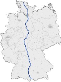

 Geographic data related to Bundesautobahn 7 at OpenStreetMap
