Bella Vista, Philadelphia
| Bella Vista | |
|---|---|
| Neighborhood of Philadelphia | |
|
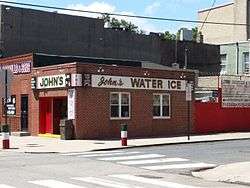
John's Water Ice, 701 Christian St June 8, 2016 | |
| Country |
|
| State | Pennsylvania |
| County | Philadelphia County |
| City | Philadelphia |
| Population (2010) | 5,898 |
| ZIP code | 19147 |
| Area code(s) | 215, 267 |
Bella Vista, Italian for "beautiful sight", is a neighborhood in the South Philadelphia section of Philadelphia, Pennsylvania.
It is bounded by 6th Street, 11th Street, South Street, and Washington Avenue.[1] It currently has a population of 5,898.[2]
History
Prior to the Act of Consolidation of 1854, Bella Vista was part of the Moyamensing Township. It was sparsely settled until the 1840s and 1850s when it became an impoverished area on the outskirts of the industrializing city. The New York Tribune noted in 1848 that the districts of Moyamensing and nearby Southwark were composed of "the most graceless vagabonds and unmitigated ruffians" as well as "loafers" who were members of various gangs.[3] In addition to Irish immigrants, it was also once home to a large portion of the city's black population, many of whom were former slaves from the South. In 1852, the Institute for Colored Youth, a school (and later college) for people of African descent, was established at 10th and Bainbridge.
During the late 1800s, Italian immigrants began settling the area in large numbers, which reshaped the neighborhood's character. One of the earliest immigrants, Antonio Palumbo, opened a boardinghouse (Palumbo's) on the corner of 9th and Catharine in 1884 that became the social center of the neighborhood's growing Italian community.
The planned construction of the South Street Expressway in the 1960s led to a drop in property values in the neighborhood. Many of the neighborhood's residents subsequently fled to the suburbs. As they did in adjacent Queen Village, developers and city planners attempted to rebrand the neighborhood and began referring to it as "Bella Vista" in the early 1970s.
The city eventually scrapped plans for the second cross-town expressway. In the late 1970s, the neighborhood began to gentrify due to its proximity to Center City. In 1982, it was featured as a case study in Michael Lang's Gentrification Amid Urban Decline: Strategies for America's Older Cities. During the same era, the neighborhood also experienced an influx of Vietnamese and Mexican immigrants, especially near Washington Ave. While much of the Italian-American community has moved away, many Italian shops and restaurants still remain clustered along the market on 9th Street.
Activities
Annual festivals in the neighborhood include the Italian Market Festival and Bella Vista Festa. Arts and cultural events in Bella Vista are centered on public concerts, coffeehouses, Mew Gallery, and the Fleisher Art Memorial.
The neighborhood has a bocce league that plays at Bardascino Park (10th and Carpenter Streets) and features a permanent community garden at 10th and Kimball.
The Samuel S. Fleisher Art Memorial, Institute for Colored Youth, Frances Ellen Watkins Harper House, and George W. Nebinger School are listed on the National Register of Historic Places.[4]
Education
School District of Philadelphia operates public schools.[1] Portions of the area are served by Andrew Jackson Elementary School,[5] William M. Meredith School,[6] George W. Nebinger School,[7] All residents of Bella Vista are zoned to Furness High School.[8]
The Free Library of Philadelphia operates the Charles Santore Branch (formerly Southwark Branch), serving Bella Vista.[9]
Public Parks
Bella Vista is home to Cianfranni Park,[10] located at 8th & Fitzwater; Bardascino Park,[11] located at 10th & Carpenter; Palumbo Park,[12] 700 block of Catherine; Palumbo Rec Center,[13] 10th & Fitzwater, and adjacent Starr Garden.[14]
References
- 1 2 "Philadelphia Neighborhoods and Place Names, A-K." City of Philadelphia. Retrieved on October 4, 2011. "Between 6th and 11th Streets, South Street to Washington Avenue."
- ↑
- ↑ South Philadelphia." Philadelphia Encyclopedia. Retrieved November 8, 2014
- ↑ National Park Service (2010-07-09). "National Register Information System". National Register of Historic Places. National Park Service.
- ↑ "Andrew Jackson Elementary School Geographic Boundaries Archived 2011-10-03 at WebCite." School District of Philadelphia. Retrieved on October 4, 2011.
- ↑ "William M. Meredith Elementary School Geographic Boundaries." School District of Philadelphia. Retrieved on October 4, 2011.
- ↑ "George W. Nebinger Elementary School Geographic Boundaries." School District of Philadelphia. Retrieved on October 4, 2011.
- ↑ "Horace Furness High School Geographic Boundaries" (Archive). School District of Philadelphia. Retrieved on October 4, 2011.
- ↑ "Charles Santore Branch." Free Library of Philadelphia. Retrieved on September 22, 2011.
- ↑ https://cianfranipark.com/
- ↑ http://www.bardascinopark.org/
- ↑ https://www.facebook.com/FriendsOfPalumboPark/
- ↑ http://palumborec.org/
- ↑ https://www.facebook.com/Starr-Garden-Neighbors-and-Friends-161282187289928/
External links
- Bella Vista Neighbors Association
- Historic Photographs of Bella Vista, PhillyHistory.org
Coordinates: 39°56′21″N 75°09′11″W / 39.93926°N 75.15295°W
