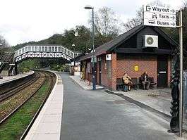
Bodmin Parkway railway station
| Bodmin Parkway | |
|---|---|
|
Bodmin Parkway, looking east | |
| Location | |
| Place | St Winnow |
| Local authority | Cornwall |
| Coordinates | 50°26′45″N 4°39′47″W / 50.4458°N 4.6630°WCoordinates: 50°26′45″N 4°39′47″W / 50.4458°N 4.6630°W |
| Grid reference | SX110640 |
| Operations | |
| Station code | BOD |
| Managed by | Great Western Railway |
| Number of platforms | 3 |
| DfT category | D |
|
Live arrivals/departures, station information and onward connections from National Rail Enquiries | |
| Annual rail passenger usage* | |
| 2010/11 |
|
| 2011/12 |
|
| 2012/13 |
|
| 2013/14 |
|
| 2014/15 |
|
| History | |
| Original company | Cornwall Railway |
| Pre-grouping | Great Western Railway |
| Post-grouping | Great Western Railway |
| 1859 | opened as Bodmin Road |
| 4 November 1983 | renamed Bodmin Parkway |
| National Rail – UK railway stations | |
| * Annual estimated passenger usage based on sales of tickets in stated financial year(s) which end or originate at Bodmin Parkway from Office of Rail and Road statistics. Methodology may vary year on year. | |
|
| |
Bodmin Parkway railway station (Cornish: Fordh Bosvena[1]) is a station on the Cornish Main Line that serves the nearby town of Bodmin and other parts of mid-Cornwall. It is situated south of the town of Bodmin in the civil parish of St Winnow, 26.75 miles (43 km) west of Plymouth.
Great Western Railway manage and the station and operate most of the train services, although CrossCountry operate some long distance services. The Bodmin and Wenford Railway operating a heritage service on the branch to the town on certain days.
The bus link to Bodmin, Wadebridge and Padstow starts from outside the main entrance.
History
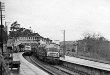
Bodmin was the most important town in Cornwall when the Cornwall Railway opened on 4 May 1859. Original proposals to build a branch to the town failed, as the company could not raise enough capital so, instead, they decided to open a station called "Bodmin Road" at a convenient point. As the agreement with Lord Vivian who owned the estate forbade the construction of a station in the estate, protracted negotiations were necessary before a new agreement could be reached.[2] When the railway opened on 4 May 1859, all that could be reported was that: "No station has yet been erected for Bodmin, owing to the site not having been immediately determined upon. It will be either near to Glynn Bridge or "Respryn" Bridge and, until it is completed, the Bodmin traffic will be accommodated at a temporary wooden shed erected near the latter place."[3] Respryn was near the entrance to Lanhydrock House, the home of Mr Robartes, a railway supporter.
The new station was finally ready to open on 27 June 1859 and was named "Bodmin Road". Because of its remote location, the station master was paid five pounds by the Post Office to carry out the duties of postmaster. He also received a special lodging allowance until a house could be provided for him two years later. A goods shed was built in 1860 at the east end of the station, behind the platform for trains to Plymouth and cattle pens were added the following year. A footbridge across the line was built by Mr Robartes in 1860 to enable visitors to reach Lanhydrock more easily. This was later replaced by a passage beneath the tracks. This path is still used by those visitors to this National Trust property who arrive by train.
In 1863 a Bodmin, Wadebridge and Cornwall Junction Railway was proposed to connect the Cornwall Railway at Bodmin Road with the Bodmin and Wadebridge Railway at Bodmin, an isolated standard gauge line owned by the London and South Western Railway. In 1864, an agreement was reached with the Cornwall Railway to work the line once it was completed, and an Act of Parliament was obtained. Capital proved difficult to raise and so the scheme failed. The line was eventually built by the Great Western Railway, opening on 27 May 1887; this meant that the goods shed had to be moved to the opposite end of the station to make room for the branch platform. This was a standard gauge line and so traffic from Bodmin to the Cornwall Railway had to be transferred at Bodmin Road until the broad gauge was converted over the weekend of 21 May 1892.[4]
The Cornwall Railway was originally a single track 7 ft (2,134 mm) broad gauge line, but a passing loop was situated at Bodmin Road to allow trains to pass. It was amalgamated into the Great Western Railway on 1 July 1889. After the route was converted to 4 ft 8 1⁄2 in (1,435 mm) standard gauge in May 1892, the line westwards to Lostwithiel was doubled on 2 July 1893 and eastwards to Doublebois on 22 December 1893.[5]
On 18 April 1895 a train derailed shortly after leaving Bodmin Road on the way to Lostwithiel. Both of the 3521 class 0-4-4-T locomotives left the rails on a curve and dragged nearly the whole of the train with them. No one was killed. It is thought that the track had been damaged by the preceding train, but the 3521 class locomotives were subsequently banned from working in pairs and were taken off fast trains until rebuilt as 4-4-0 tender locomotives.[2]
The Great Western Railway was nationalised into British Railways from 1 January 1948. The line to Bodmin General lost its passenger service on 30 January 1967. Goods facilities at Bodmin Road were withdrawn the following year, however goods traffic continued on the branch line until 3 October 1983. The line was subsequently taken over by the Bodmin and Wenford Railway and reopened as a heritage railway on 17 June 1990. In 1989 the old station buildings, except for the signal box, were demolished and replaced by modern brick and glass structures. The station had been renamed 'Bodmin Parkway' on 4 November 1983.[6]
Description
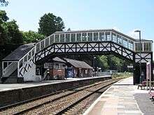
The railway here runs from north-east (Plymouth) to south-west (Penzance). The entrance to the station is on the south-east side of the line, and so the approach road from the road to Bodmin passes under the line north of the platforms.[7] Plymouth Citybus operates a bus service (to Bodmin and Padstow in one direction and Liskeard in the other) from the small station car park. A footpath leads from the car park to Lanhydrock House, passing under the line at the west end of the station.
The brick built First Great Western booking office is next to the entrance on the westbound platform, and a matching building on the opposite platform serves as a waiting room for passenegers travelling towards Plymouth. The old signal box, now used as a cafe, is situated to the north-east of the booking office and the footbridge is situated beyond this. This is an old Great Western Railway wooden structure but with stairs in two different styles.
There is no booking office for the Bodmin and Wenford trains so passengers buy their tickets from the guard. These use the opposite face of the platform used by mainline trains towards Plymouth. The Bodmin line curves sharply away to the north at the west end of the platform, and between this line and the main line is the exchange siding used for occasional movements between the two railways, and a large modern carriage shed alongside that is used to store rolling stock for the Bodmin and Wenford Railway.
Signalling
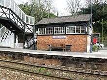
When the Cornwall Railway opened its trains were controlled by independently operated signals; there were no signal boxes but an electric telegraph linked the stations so that the policemen who controlled the dispatch of the trains could communicate. It is unclear when a signal box was first provided at Bodmin Road was opened, but the surviving structure is reported to have been brought into use either in 1893 with the doubling of the line,[8] or even as late as 1897.[9]
The signal box was fitted with a new locking frame in 1912 and was rebuilt circa 1928. The next signal box to the east was at Largin, and to the west was at Lostwithiel. A new signal box was opened on 31 January 1931 at Onslow Sidings (to serve a china clay works), 1.25 miles (2.01 km) towards Largin, but closed again on 10 November 1968. The signal box at Bodmin Road was itself closed on 30 May 1985 and Largin too on 14 December 1991.[9]
The single track of the Bodmin branch was controlled by an electric train staff until 28 December 1950, after which an electric key token was used. Signalling on the branch was removed on 27 March 1968, after which points were operated by independent levers. The connection from the main line into the exchange siding is operated by a lever frame under the supervision of Lostwithiel signal box.[9]
Services
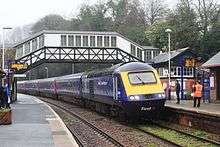
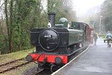
Bodmin Parkway is served by most Great Western Railway trains on the Cornish Main Line between Penzance and Plymouth with one train per hour in each direction. Some trains run through to or from London Paddington station, including the Night Riviera overnight sleeping car service; there are also occasional Great Western services to Newquay.[10] There are a limited number of CrossCountry trains providing a service from Penzance to Glasgow Central or Manchester Piccadilly in the morning and returning in the evening. On summer weekends some CrossCountry trains serve Newquay.[11]
| Preceding station | |
Following station | ||
|---|---|---|---|---|
| Liskeard | Great Western Railway Cornish Main Line |
Lostwithiel | ||
| CrossCountry The North To Penzance |
Lostwithiel | |||
| CrossCountry The North To Newquay |
Newquay | |||
| |
||||
| Colesloggett Halt | Bodmin and Wenford Railway | Terminus | ||
See also
References
| Wikimedia Commons has media related to Bodmin Parkway railway station. |
- ↑ http://www.magakernow.org.uk/idoc.ashx?docid=f3fabe0c-206f-4e0c-8889-4ce4a5060e5b&version=-1
- 1 2 Bennett, Alan (1988). The Great Western Railway in Mid Cornwall. Southampton: Kingfisher Railway Publications. ISBN 0-946184-53-4.
- ↑ "Railway Special Edition". West Briton and Cornwall Advertiser. 1859.
- ↑ MacDermot, E T (1931). History of the Great Western Railway. 2 (1863-1921) (1 ed.). London: Great Western Railway.
- ↑ Cooke, RA (1977). Track Layout Diagrams of the GWR and BR WR, Section 11: East Cornwall. Harwell: RA Cooke.
- ↑ Michell, Vic; Smith, Keith (1998). Wendford Bridge to Fowey. Country Railway Routes. Midhurst: Middleton Press. ISBN 1-901706-09-5.
- ↑ St Austell and Liskeard. Explorer Map (B1 ed.). Southampton: Ordnance Survey. 2005. ISBN 0-319-23708-7.
- ↑ Vaughan, John (2009). An Illustrated History of the Cornish Main Line. Horsham: Oxford Publishing Company. ISBN 978-0-86093-625-1.
- 1 2 3 Pryer, GA. Signal Box Diagrams of the Great Western & Southern Railways, Volume 14: GWR Lines Plymouth and East Cornwall. Weymouth: GA Pryer. ISBN 0-9532460-5-1.
- ↑ Table 135 National Rail timetable, May 2016
- ↑ Table 51 National Rail timetable, May 2016
