Borzna
| Borzna Борзна | |||
|---|---|---|---|
| Town | |||
|
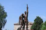
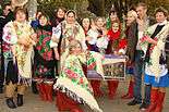
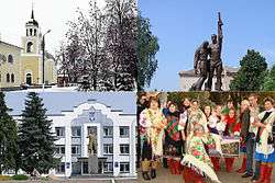
Top left:Borzna Nicholas Church, Top right:Monument to the lost countrymen, Bottom left:Borzna City Hall and Vladimir Lennin's Statue, Bottom right:Borzna Pokrovsky Fair on every October | |||
| |||
 Borzna Location of Borzna | |||
| Coordinates: 51°15′00″N 32°36′00″E / 51.25000°N 32.60000°ECoordinates: 51°15′00″N 32°36′00″E / 51.25000°N 32.60000°E | |||
| Country |
| ||
| Raion | Borznianskyi Raion | ||
| Oblast | Chernihiv Oblast | ||
| Founded | 16th century | ||
| Сity status on | 1966 | ||
| Government | |||
| • Mayor | Vladimir Gumensky | ||
| Area | |||
| • Total | 107.8 km2 (41.6 sq mi) | ||
| Population (2011) | |||
| • Total |
| ||
| • Density | 110/km2 (300/sq mi) | ||
| Time zone | EET (UTC+2) | ||
| • Summer (DST) | EEST (UTC+3) | ||
| Postal code | 16400- | ||
| Area code(s) | +380-4653 | ||
Borzna (Ukrainian: Борзна, Ukrainian pronunciation: [bɔrzˈnɑ]; also referred to as Borsna), is an historic town in northern Ukraine. It is the administrative center of the Borzna Raion (Borzna district) in the Chernihiv Oblast. The estimated population of the town is around 10,640 (as of 2011).
Location

Looking at a map, one can easily locate Borzna in northeastern Ukraine. First, find the capital, Kiev. Go north a few miles up the Dnieper river to where the Desna River feeds into it. The Desna comes from the north where, at a city Chernihiv, it curves east. Along this course, where the river bulges southward, is Borzna. More specifically, it is located next to an international highway connecting Kiev and Moscow (E101). Chernihiv is about 100 km (62 mi) away. Borzna has no railway (the nearest railway stations being Doch (14 km or 9 mi) with north-south routes and Plysky (20 km or 12 mi) with west-east routes.
The city derives its name from the river it lies on, a tributary of the Desna.
Climate
Borzna has a humid continental climate (Koppen Dfb). The warmest months are June, July, and August, with mean temperatures of 19 °C (66 °F). The coldest are December, January, and February, with mean temperatures of −7 °C (19 °F). The highest ever temperature recorded in the town was 41.3 °C (106.3 °F) on July 2010. The coldest temperature ever recorded in the city was −35.9 °C (−32.6 °F) on January 1987. Snow cover usually lies from mid-November to the end of March, with the frost-free period lasting 180 days on average, but surpassing 200 days in recent years.
History
Evidence of settlement in the area of present-day Borzna dates back to the Neolithic era, with Bronze Age and Scythian remains also having been unearthed. According to some modern writers, the earliest fortress (8th—13th centuries) would have been destroyed by the Batu Khan in the 1239.[1]
Borzna was known during the 16th century as selishche, a farming community. As Borzna, it was founded in 1633. The area had been part of the Polish-Lithuanian Commonwealth (in the Kijów Voivodeship of the Crown of Poland) since before the Union of Lublin. Control of the town was wrested from the Commonwealth during the Khmelnytsky Uprising, after which natives of Ruthenia gained some degree of autonomy under Hetman Bohdan Khmelnytsky and his Cossack state. In 1648, Borzna was transformed into a Cossack regional center Borzna Regiment, and then, in 1650 — sotnia of the Nizhyn Regiment.

Built in the mid-19th century

Built in the late 19th century
By 1634 Borzna was granted Magdeburg Rights.
After 1654, the town became part of the Tsardom of Russia and became a county town in the Chernigov governorate in 1782, adopting the emblem of the Russian period.[2]
240 families of the cossacks and 180 families of the peasants living in the town of Borzna in 1748. According to the census of 1859 there were total population of the town of Borzna is about 8,453.
Because of its distance from the railway (14 km), it has not grown (1897 pop 8,582). From 1923 Borzna is the administrative center of the Borznyanskyi raion (Borzna district).
In World War II, the town was occupied by Nazi Germany from September 11, 1941 to September 7, 1943. On January 18, 1942, the Germans rounded up all the local Jews they could find and massacred them at Shapovalivka. 126 people were killed, 179 removed to Germany.[3]
August 26, 1966, Borzna attributed to the category of cities of district subordination.
Nowadays
While the town benefits from vast farming lands surrounding it, it also has a metalwork and electronic chips plant, a brick factory, a lumber-processing factory, and a food industry.[2] Among its educational institutions, there is an Agricultural Technicum, Panteleimon Kulish Gymnasium, and Khrystyna Alchevska secondary school, as well as a musical school.
Borzna has a concert hall (The House of Culture), Museum of Oleksandr Sayenko (an original artist who, despite being deaf and dumb, gained prominence by inventing his own technique of creating pictures out of straw), Museum of History, and an historical-memorial complex Hannyna Pustyn (commemorating a famous Ukrainian writer and activist of the 19th century Panteleimon Kulish and a peasant life writer Hanna Barvinok,[4] (husband and wife) which is a ten-minute drive away in the nearby village of Motronivka.
The local newspaper the Visti Borznyanshchyny (English: The Borzna Herald) is published twice a week. The local community also operates a radio station which regularly produces programs about local events.
Notable people
- Panteleimon Kulish — writer, critic, poet, folklorist, and translator
- Semen Paliy — Ukrainian Cossack polkovnyk (colonel)
- Ivan Plyushch — Ukrainian politician and former Chairman of the Verkhovna Rada (Ukrainian parliament)
- Pavlo Polubotok — Acting Hetman of the Cossack era of Ukraine
- Kharchenko Ivan Ustinovich — Hero of the Soviet Union, awarded for the World War II battles, born in the village Komarivka of the current Borzniansky rayon
Gallery
-

Monument to the lost countrymen
-
Meadows near the Borzna
-
The Stork Nest, Borzna
-
New Year's Eve. 1967
-

Pokrovsky fair in Borzna
-

Historical-memorial complex Hannyna Pustyn
References
- ↑ According to local historian Michael Moskalenko from Borzna
- 1 2 Borzna. Encyclopedia of Ukraine
- ↑ Holocaust history. Borzna
- ↑ Hanna Barvinok. Encyclopedia of Ukraine
Bibliography
- Icтopiя мicт i ciл Укpaїнcькoї CCP — Чернiгiвськa область (1972) (History of Towns and Villages of the Ukrainian SSR — Chernihiv Oblast), Kiev. (Ukrainian)
- Martin Dimnik (2003). The Dynasty of Chernigov, 1146-1246. Campridge University Press. ISBN 0-521-82442-7.
- David S. DuVal. (2004). Ukrainian Soul: The Story Of The Family Volkoff From Borzna. Lincoln, NE: iUniverse. — 193 p. ISBN 0-595-31967-X
External links
- Official Borzna District Website
- Borzna District Council (Ukrainian)
- The murder of the Jews of Borzna during World War II, at Yad Vashem website.


