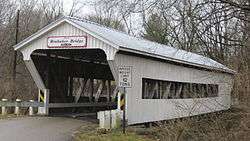
Brubaker Covered Bridge
|
Brubaker Covered Bridge | |
|
Western portal and southern (upstream) side of the bridge | |
  | |
| Nearest city | Gratis, Ohio |
|---|---|
| Coordinates | 39°39′6″N 84°32′39″W / 39.65167°N 84.54417°WCoordinates: 39°39′6″N 84°32′39″W / 39.65167°N 84.54417°W |
| Area | less than one acre |
| Built | 1887 |
| Architect | Everett S. Sherman |
| Architectural style | One-span Childs truss |
| NRHP Reference # | 75001527 [1] |
| Added to NRHP | June 11, 1975 |
Brubaker Covered Bridge runs across Sandy Run, to the west-northwest of Gratis Township, Preble County, Ohio. It is 85 feet (26 m) in length, and was built in 1887 by Everett S. Sherman. The bridge is of Childs Truss construction.
References
- ↑ National Park Service (2009-03-13). "National Register Information System". National Register of Historic Places. National Park Service.
External links
 Media related to Brubaker Covered Bridge at Wikimedia Commons
This article is issued from Wikipedia - version of the 11/28/2016. The text is available under the Creative Commons Attribution/Share Alike but additional terms may apply for the media files.
