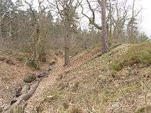
Caesar's Camp, Bracknell Forest

Caesar's Camp is an Iron Age hill fort around 2400 years old. It is located just in Crowthorne civil parish to the south of Bracknell in the English county of Berkshire.[1]
History
Caesar's Camp is thought to have been established around 500–300BC. It is the only hill fort of its type that has been identified in east Berkshire.[2] Because the area it was built on was sludgy for most of the year, surrounded by dense forest, and had a thick bed of sandstone beneath the top layers of soil, it was not suitable for farming – the community at Caesar's Camp was therefore dependent on the produce of neighbouring villages, in areas such as Binfield and Arborfield. Caesar's Camp was therefore most likely used as an assembly point and a marketplace. Its huge outer walls and 1-mile-long (1.6 km) dump rampart also suggest that it was used as a safe haven in case of attack.
Caesar's Camp appears to have fallen under the rule of Cunobelin, king of the Catuvellauni tribe in the first century AD from a coin discovered in the interior.[2] Soon after, the Romans invaded England; after this time, there is no evidence that Caesar's Camp continued to exist as an inhabited community. A road from its south entrance was later built, connecting it to the Devil's Highway. After the first century, Caesar's Camp was likely used as a resting beacon or storage facility.
A redoubt roughly 40 m across in the fort is thought to be part of a defence line built in 1792 in preparation for the Napoleonic Wars.[1]
Description
The layout consists of a number of steep banks and ditches in the shape of an oak leaf, enclosing a large flat area of a settlement.[3] It is north of the Roman road known as The Devil's Highway which connected Londinium to Calleva Atrebatum (Silchester). It is within the Crowthorne Woods part of Swinley Forest crown plantation and is located off Nine Mile Ride approximately 0.75 miles (1.2 km) from the Look Out visitor centre. On clear days, central Bracknell and Crowthorne, including Broadmoor hospital, are visible from its highest points. The camp falls within the Broadmoor to Bagshot Woods and Heaths Site of Special Scientific Interest.
It is an entirely hand-built complex.[4] The camp has suffered significant erosion, both natural and man-made. Efforts have been made by the local council to try to restore some of the natural parts because as well as being a historic site it is also home to a number of wildlife species.[4] A geophysical survey of 2 ha of the site was undertaken in 1995 before the restoration work began. The survey found little evidence for sustained occupation or many structures but did find a ditch type anomaly within the western ramparts and a scatter of pit type anomalies.[5]
1978 People's Free Festival
The site was reoccupied between 29 August and 8 September 1978, when it became the location of the last of the Windsor Free Festivals in 1978, after the forced removal of those attempting to attend the People's Free Festival, in Windsor Great Park, by police.[6]
References
- 1 2 Historic England. "Details from listed building database (1016334)". National Heritage List for England.
- 1 2 Cotton, Aylwin (1962). "Berkshire Hill Forts". Berkshire Archaeological Journal. Berkshire Archaeological Society. 60: 30–52. doi:10.5284/1000017. Retrieved 2016-02-23.
- ↑ Hogg, A H A (1975). Hill-forts of Britain. Hart-Davis. p. 157. ISBN 978-0246108357.
- 1 2 "Caesar's Camp". Bracknell Forest Council. Retrieved 2016-02-23.
The hillfort which covers an area of about 17.2 acres (7 hectares) and is surrounded by a mile-long ditch, is a remarkable piece of engineering having been constructed entirely by hand using basic tools.
- ↑ Linford, N (1995). "Caesar's Camp, Windsor Forest, Berks, Report On Geophysical Survey, 1995". Historic Buildings and Monuments Commission for England. Retrieved 2016-02-24.
- ↑ "Caesar's Camp free festival -1978- Peoples Free Festival 1978". Ukrockfestivals.com. Retrieved 2012-08-08.
External links
| Wikimedia Commons has media related to Caesar's Camp, Bracknell Forest. |
Coordinates: 51°22′59″N 0°45′36″W / 51.383°N 0.760°W