Colorado Boulevard
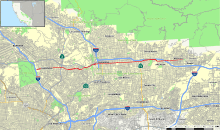
 Map of Los Angeles County in southern California with Colorado Boulevard highlighted in red | |
| West end |
|
|---|---|
| Major junctions |
Arroyo Parkway ( |
| East end | Shamrock Ave in Monrovia, California |

Colorado Boulevard (or Colorado Street) is a major east–west street in Southern California. It runs from Griffith Park in Los Angeles east through Glendale, the Eagle Rock section of Los Angeles, Pasadena, and Arcadia, ending in Monrovia. The full route was once various state highways but is now locally maintained in favor of the parallel Ventura Freeway (CA-134) and Foothill Freeway (I-210).
West end
Colorado Street begins at Interstate 5 (Golden State Freeway) as a short freeway spur, originally carrying State Route 134 until it was moved north onto the Ventura Freeway. After crossing the Los Angeles River, there are two interchanges — with Edenhurst Avenue and San Fernando Road - before it becomes a surface street. At the second interchange it enters Glendale.
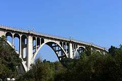
At the east border of Glendale, Colorado Street becomes Colorado Boulevard as it crosses State Route 2 (Glendale Freeway) into Los Angeles (specifically, the neighborhood of Eagle Rock). Another short freeway spur splits west of the intersection with Figueroa Street, heading northeast to the Ventura Freeway. This spur also carried SR 134 after the Ventura Freeway was built to the east but before it was built west of the split with the spur. After crossing Figueroa Street, Colorado Boulevard splits from Linda Vista Avenue and then passes over the Arroyo Seco on the Colorado Street Bridge into Pasadena.
Through Pasadena
In Pasadena, Colorado Boulevard crosses the short State Route 710 spur and forms the north end of State Route 110 (Arroyo Parkway). Colorado Street, renamed "Boulevard" in 1958, runs through Old Town Pasadena from Arroyo Parkway to Orange Grove Boulevard. It is the north–south zero axis of the street grid in Pasadena (the east–west axis is Fair Oaks Avenue). The Tournament of Roses parade route travels north on Orange Grove Avenue then east along Colorado Boulevard as far as Sierra Madre Boulevard, where it heads north to Victory Park. Most major Pasadena attractions are found along or within one block of Colorado Boulevard. Pasadena City College is located at 1570 E. Colorado Boulevard. The street was mentioned in Jan and Dean's 1964 hit song The Little Old Lady from Pasadena. The road leaves the city into unincorporated East Pasadena, where it intersects Rosemead Boulevard (Former State Route 19).
Through Arcadia and Monrovia
Colorado Boulevard becomes Colorado Street as it crosses Michillinda Avenue from East Pasadena into Arcadia. Through Arcadia, the street parallels the Foothill Freeway, providing access to many of the neighborhoods in west Arcadia; freeway access is provided via a separated interchange with Baldwin Avenue. Colorado Street then turns southeast and splits into two streets--Colorado Boulevard, which continues east, and Colorado Place, a short segment of old US 66 that goes southeast to merge with Huntington Drive near the Santa Anita Racetrack.
From the split, Colorado Boulevard (originally named Orange Street) becomes a primarily residential street, with some commercial zones near Santa Anita Avenue in Arcadia. The street passes under the Foothill Freeway between First and Second Streets in Arcadia with no access, in front of Monrovia High School, and through Old Town Monrovia before ending at Shamrock Avenue at Recreation Park in Monrovia. (This segment of Shamrock Avenue was once part of an early alignment of US 66 and had been named Foothill Boulevard.)
The Santa Anita Depot, built in 1890 to serve Lucky Baldwin, and the people of Rancho Santa Anita, was located at Colorado Boulevard and Old Ranch Road. It was moved to the Los Angeles County Arboretum and Botanic Garden during the construction of the 210 Foothill Freeway in 1970.
History
The most original portion of Colorado Boulevard ran from Orange Grove Boulevard to Broadway, now Arroyo Parkway. This portion of the street always contained many shops, banks, hotels, and major commercial industries. By the late 19th century, this part of Colorado had become so popular, it was becoming a traffic bottleneck, and as early as May 1900 there were public outcries to the City Council to widen the road. It wasn't until 1929 that the City undertook the major and unprecedented task of cutting back the buildings along Colorado 14 feet (4.3 m) on each side. This undertaking created a monumental amount of legal red tape as well as many engineering dilemmas which were handled with amazing results. At the same time many of the Victorian facings on the buildings were replaced with Spanish and Art Deco designs.
Colorado Street and Colorado Boulevard carried pre-1964 Legislative Route 161 from its west end to the merge with Huntington Drive (via Colorado Place). This was signed as State Route 134 west of Figueroa Street, U.S. Route 66 Alternate (US 66 before the end of 1940) from Figueroa Street to Arroyo Parkway, and U.S. Route 66 from Arroyo Parkway to Huntington Drive.
In 1954, the Colorado Freeway was opened between Holly Street in Pasadena and Eagle Vista Drive and Colorado Boulevard in Eagle Rock to help alleviate traffic congestion due to the narrow Colorado Street Bridge over the Arroyo Seco. The new freeway connected the two communities until 1971, when the entire freeway was closed and upgraded, as well as partially rerouted as the new Ventura Freeway. A short segment of the original Colorado Freeway remains as an on-ramp/off-ramp between Colorado Boulevard in Eagle Rock and the Figueroa Street off-ramp of the present Ventura Freeway.
In the 1964 renumbering, LR 161 remained State Route 134 west of Pasadena, though this was being moved to the new alignment (now the Ventura Freeway); until the freeway was completed through Pasadena in the mid-1970s, Colorado Boulevard was still signed as State Route 134 between Orange Grove Avenue and Arroyo Parkway. Through and east of Pasadena, LR 161 became State Route 248, but was signed as US 66 and continued east on Huntington Drive to the interchange with Interstate 210 (Foothill Freeway) in Monrovia.[1]
The US 66 shields began to come down along the length of Route 248 in 1975, soon after Interstate 210 was completed through Pasadena. SR 248 was never signed as such, though it did appear on some maps in the 1970s and 1980s. The segment within the city of Pasadena was deleted from the state highway system in 1986. The rest was removed in 1992.[1] Along with the moving of SR 134 to the Ventura Freeway, this resulted in Colorado Street and Colorado Boulevard becoming a local road.
Transit
Many buses serve Colorado Boulevard. Metro Local lines 180 and 181 and Metro Rapid line 780 serve most of Colorado Boulevard. Also, Metro Local lines 177, 256, 686, and Foothill Transit line 187 serve parts of Colorado Boulevard, beginning in Old Pasadena. Metro Local lines 28, 81, 175, 180, 181, Metro Rapid line 780 and LADOT DASH Eagle Rock/Highland park serves most of Colorado Boulevard in Eagle Rock. Metro Local Lines 28, 175, 183 and Glendale Transit line 6 serve Colorado Street in Glendale.