Castro of Monte Mozinho
| Castro of Monte Mozinho (Castro de Monte Mozinho) | |
| Fortified settlement of Monte Mozinho, Penafiel City of the Dead | |
| Castro | |
 A view at the top of the hill of Monte Mozinho | |
| Official name: Povoado fortificado de Monte Mozinho/Cidade Morta de Penafiel | |
| Named for: Monte Mozinho | |
| Country | |
|---|---|
| Region | Norte |
| Subregion | Tâmega |
| District | Porto |
| Municipality | Penafiel |
| Location | Oldrões |
| Architects | unknown |
| Style | Calcolithic |
| Material | Granite |
| Owner | Portuguese Republic |
| For public | Public |
| Easiest access | Road midway along the Estrada Municipal between Galegos and Valpedre |
| Management | Instituto Gestão do Patrimonio Arquitectónico e Arqueológico |
| Status | Property of Public Interest Imóvel de Interesse Público |
| Listing | Decree 37/077, Diário do Governo, Série 1, 228 (29 September 1948) |
| Wikimedia Commons: Castro de Monte Mozinho | |
The Castro of Monte Mozinho (Portuguese: Povoado fortificado de Monte Mozinho/Cidade Morta de Penafiel) is a Neolithic fortified settlement, sometimes referred to as the City of the Dead, situated in the civil parish of Oldrões, in the municipality of Penafiel in the Tâmega Subregion of the Portuguese district of Porto.
History
The site dates to a proto-historic period still largely undefined.[1] Its first period of occupation can be traced to the 1 century BCE.[1]
By the Middle Ages the site continued to be occupied by a small community.[1]
On 8 November 2004, a interpretative centre was inaugurated by the Secretária de Estado das Artes e Espectáculos (Secretary-of-State for the Arts and Performances), Teresa Caeiro.[1]
In 1930, archaeological excavations under the direction of Abílio Miranda. Excavations were continued in 1943, under the direction of Elísio Ferreira de Sousa, and in 1947, under the supervision of Fernando Russell Cortez.[1]
Between 1974 and 1979, a new excavation was carried out by Carlos A. Ferreira de Almeida.[1] A similar excavation began in 1982 (ending ten years later) by the archaeologist Teresa Soeiro.[1]
The artefacts unearthed included fragments of ceramics dating to the Iron Age and Roman occupation, including pots, glass, Imbrex and tegula, millstones, coins and metallic elements (including artesnal, defensive and agricultural implements).[1] In addition there were decorative jewellry in silver and bronze Transmontanan fibulas, in addition to granite statuary and alters (an epigraph, fragment dedicated to Jupiter and another truncated to the foculus).[1] These and other artefacts were housed and on display in the Museu Municipal de Penafiel (Penafiel Municipal Museum), Museu de Etnografia e História do Porto (Porto Museum of Ethnography and History) and the Museu de Antropologia da Universidade do Porto (University of Porto's Anthropologic Museum).[1]
Architecture
The fortified settlement was located in an isolated, rural hilltop covered in pine forest, overlooking the Ribeira da Camba.[1] It is erected in the southern part of the municipality, between the parishes of Santo Estêvão de Oldrões and Galegos.[1]
The castro covers an area of 20 hectares, defined by four lines of walls that encircle the settlement, at a maximum of 3.5 metres (11 ft) thick at the doorways.[1] The settlement was structured by principal dwellings oriented north to south, articulated with lateral lodgings, aligned orthogonally.[1]
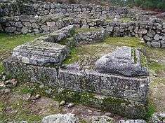
Archaeological excavations completed during its history exhumed circular constructions, with or without vestibule, and rectangular plans, with habitational structures framed by dwellings and defined by the walls, forming blocks.[1] Above the settlement is a vast ellipsoid courtyard, also defined by wall, presenting a space that could have acted as a public space.[1]
Close to the upper courtyard and principal lodgings, accessible by a bent ramp, is a probable temple constituted by a rectangular cell and podium along the longest side and fronted by other rectangular constructions.[1] In the third wall is a possible funerary monument, heavily ruined, but with a good foundation marked by a rectangular cavity conserved and framed by stones.[1] It is a turriform mausoleum with columns and sculptures, and many elements lying around its base.[1] To the northwest, near the outer wall was a necropolis made up of two sepulchral boxes structured with small stones, covered by slate, with shelf where ceramic containers were deposited.[1]
References
Notes
- 1 2 3 4 5 6 7 8 9 10 11 12 13 14 15 16 17 18 19 20 Sereno, Isabel; Amaral, Paulo (1994), SIPA, ed., Povoado fortificado de Monte Mozinho/Cidade Morta de Penafiel (IPA.00003884/PT011311130011) (in Portuguese), Lisbon, Portugal: SIPA – Sistema de Informação para o Património Arquitectónico, retrieved 7 November 2016
Sources
- Andrade, Vieira de (1920), "Monte Mosinho", Boletim da Associação dos Arqueólogos Portugueses (in Portuguese) (13) (Série 5 ed.), Lisbon, Portugal, pp. 275–277
- Machado, F.S. Lacerda (1920), Uma cidade morta no Monte Mozinho ou o castro de Santo Estevão de Oldrões (in Portuguese), Coimbra, Portugal
- Pinho, José de (1931), A necrópole calaico-romana do Mósinho (in Portuguese) (2), Penafiel, Portugal: Pena-Fidelis
- Sousa, Elísio Ferreira de (1954), Relatório das escavações levadas a efeito no Monte Mósinho, Douro Litoral (in Portuguese) (Série 6 ed.), Porto, Portugal, pp. 136–149
- Sousa, Elísio Ferreira de (1965), As moedas encontradas na citânia do Mosinho (cidade morta) e as suas possíveis conclusões (in Portuguese) (4), Porto, Portugal: Lucerna, pp. 249–269
- Almeida, Carlos A. Ferreira de (1974), Escavações no Monte Mozinho (1974) (in Portuguese), Penafiel, Portugal
- Almeida, Carlos A. Ferreira de (1977), Escavações no Monte Mozinho (in Portuguese) (1975-1976) (II ed.), Penafiel, Portugal
- Almeida, Carlos A. Ferreira de (1980), O templo do Mozinho e seu conjunto, Portugalia (in Portuguese) (1) (Nova Série ed.), Porto, Portugal, pp. 51–56
- Soeiro, Teresa (1984), Monte Mózinho. Apontamentos sobre a ocupação entre Sousa e Tâmega em época romana, Penafiel-Boletim Municipal de Cultura (in Portuguese) (1) (Série 3 ed.), Penafiel, Portugal, pp. 123–299
- Ponte, Salete da (1984), Fíbulas de sítios a Norte do rio Douro (in Portuguese) (s/n), Porto, Portugal: Lucerna, pp. 131, 133–134, 135–136
Coordinates: 41°08′47″N 8°18′40″W / 41.1464°N 8.3111°W