Cedar Creek Bridge (Rosie, Arkansas)
|
Cedar Creek Bridge | |
 | |
  | |
| Nearest city | Rosie, Arkansas |
|---|---|
| Coordinates | 35°38′34″N 91°32′26″W / 35.64278°N 91.54056°WCoordinates: 35°38′34″N 91°32′26″W / 35.64278°N 91.54056°W |
| Area | less than one acre |
| Built | 1941 |
| Architectural style | Closed Spandrel Deck Arch |
| MPS | Historic Bridges of Arkansas MPS |
| NRHP Reference # | 95000613[1] |
| Added to NRHP | May 18, 1995 |
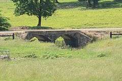
The Cedar Creek Bridge is a historic bridge in rural southern Independence County, Arkansas. It is located on Goodie Creek Road (County Road 235), about 1.5 miles (2.4 km) south of its junction with Arkansas Highway 14. It is a two-span stone masonry structure, spanning Cedar Creek with two closed-spandrel arches having a total length of 30 feet (9.1 m). Its deck is 24.1 feet (7.3 m) wide, with a total structure width of 26.1 feet (8.0 m), including the parapets at the sides. The bridge was built 1941, and was probably designed by an engineer of the state's highway department.[2]
The bridge was listed on the National Register of Historic Places in 1995.[1]
See also
- National Register of Historic Places listings in Independence County, Arkansas
- List of bridges on the National Register of Historic Places in Arkansas
References
- 1 2 National Park Service (2010-07-09). "National Register Information System". National Register of Historic Places. National Park Service.
- ↑ "NRHP nomination for Cedar Creek Bridge" (PDF). Arkansas Preservation. Retrieved 2015-07-11.
| Topics | |
|---|---|
| Lists by states |
|
| Lists by insular areas | |
| Lists by associated states | |
| Other areas | |
| |
This article is issued from Wikipedia - version of the 12/2/2016. The text is available under the Creative Commons Attribution/Share Alike but additional terms may apply for the media files.