Centenary Quay
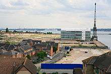
Centenary Quay (also known as Woolston Riverside) is a new development which has commenced in the suburb of Woolston in Southampton, England. The development is being built on the site of 31 acres, which had been home to Vosper Thorneycroft shipbuilders because of its ideal placement on the eastern bank of the River Itchen.[1]
Plans
The initial plans were submitted in May 2008 for a mixed residential and commercial development of the quay. There are also plans for a yacht building firm to move in and create 700 new jobs along with a 46,500 sq ft (4,320 m2) supermarket. The plans include houses of different types, Crest Nicholson are offering 2,3 or 4 bedroom houses as well as building three large skyscrapers which will contain hundreds of flats, a hotel and restaurants. The plans were agreed in August of that year.[2]
Progress

By late 2008, work began to clear the site of harmful materials and any other pollutants such as hydrocarbons, asbestos and harmful metals leftover from the demolition of the dated Vosper Thornycroft warehouses and workshops. BAM Nuttall were contracted to complete this part of the work, and it soon became apparent that it would turn into a more complex operation than previously thought. Therefore this delayed progress.[3]
In July 2010, a foundation laying ceremony was held to commence the beginning of building work. Local councillors attended and the foundation stone was laid by the Secretary of State for Communities and Local Government, Eric Pickles.[4][5]
In January 2011 Phase One of the development, development of around fifty three-bedroom terrace houses, neared completion.
References
- ↑ "Centenary Quay". Centenary Quay. Retrieved 2011-01-22.
- ↑ "Developments Details". Invest-In-Southampton. Retrieved 2011-01-22.
- ↑ "BAM Nuttall". BAM Nuttall. Retrieved 2011-01-22.
- ↑ "SEEDA launches Woolston Riverside development". Invest-In-Southampton. 2010-07-29. Retrieved 2011-01-22.
- ↑ "Minister lays the foundations at Centenary Quay - Homes and Communities Agency (HCA)". Homesandcommunities.co.uk. Retrieved 2011-01-22.
Coordinates: 50°53′40″N 1°22′56″W / 50.89448°N 1.38228°W