Choctaw County, Mississippi
| Choctaw County, Mississippi | |
|---|---|
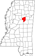
 Location in the U.S. state of Mississippi | |
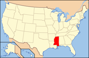
 Mississippi's location in the U.S. | |
| Founded | 1833 |
| Named for | Choctaw people |
| Seat | Ackerman |
| Largest town | Ackerman |
| Area | |
| • Total | 420 sq mi (1,088 km2) |
| • Land | 418 sq mi (1,083 km2) |
| • Water | 1.7 sq mi (4 km2), 0.4% |
| Population | |
| • (2010) | 8,547 |
| • Density | 20/sq mi (8/km²) |
| Congressional district | 1st |
| Time zone | Central: UTC-6/-5 |
Choctaw County is a county located in the U.S. state of Mississippi. As of the 2010 census, the population was 8,547.[1] Its county seat is Ackerman.[2] The county is named after the Choctaw tribe of Native Americans who long occupied this territory as their homeland.
Geography
According to the U.S. Census Bureau, the county has a total area of 420 square miles (1,100 km2), of which 418 square miles (1,080 km2) is land and 1.7 square miles (4.4 km2) (0.4%) is water. The Big Black River forms the county's northern border.[3]
Adjacent counties
- Webster County, Mississippi - north
- Oktibbeha County, Mississippi - east
- Winston County, Mississippi - southeast
- Attala County, Mississippi - southwest
- Montgomery County, Mississippi - west
National protected areas
- Natchez Trace Parkway (part)
- Tombigbee National Forest (part)
Demographics
| Historical population | |||
|---|---|---|---|
| Census | Pop. | %± | |
| 1840 | 6,010 | — | |
| 1850 | 11,402 | 89.7% | |
| 1860 | 15,722 | 37.9% | |
| 1870 | 16,988 | 8.1% | |
| 1880 | 9,036 | −46.8% | |
| 1890 | 10,847 | 20.0% | |
| 1900 | 13,036 | 20.2% | |
| 1910 | 14,357 | 10.1% | |
| 1920 | 12,491 | −13.0% | |
| 1930 | 12,339 | −1.2% | |
| 1940 | 13,548 | 9.8% | |
| 1950 | 11,009 | −18.7% | |
| 1960 | 8,423 | −23.5% | |
| 1970 | 8,440 | 0.2% | |
| 1980 | 8,996 | 6.6% | |
| 1990 | 9,071 | 0.8% | |
| 2000 | 9,758 | 7.6% | |
| 2010 | 8,543 | −12.5% | |
| Est. 2015 | 8,299 | [4] | −2.9% |
| U.S. Decennial Census[5] 1790-1960[6] 1900-1990[7] 1990-2000[8] 2010-2013[1] | |||
As of the 2010 United States Census, there were 8,543 people residing in the county. 68.1% were White, 30.2% African American, 0.3% U.S. Census, 0.2% Asian, 0.1% Pacific Islander, 0.1% from some other race and 1.1% of two or more races. 1.4% were Hispanic or Latino of any race.
As of the census[9] of 2000, there were 9,758 people, 3,686 households, and 2,668 families residing in the county. The population density was 23 people per square mile (9/km²). There were 4,249 housing units at an average density of 10 per square mile (4/km²). The racial makeup of the county was 68.03% White, 30.68% Black or African American, 0.31% Native American, 0.13% Asian, 0.01% Pacific Islander, 0.42% from other races, and 0.42% from two or more races. 0.81% of the population were Hispanic or Latino of any race.
There were 3,686 households out of which 32.60% had children under the age of 18 living with them, 53.30% were married couples living together, 14.60% had a female householder with no husband present, and 27.60% were non-families. 25.00% of all households were made up of individuals and 12.20% had someone living alone who was 65 years of age or older. The average household size was 2.56 and the average family size was 3.06.
In the county the population was spread out with 27.80% under the age of 18, 8.80% from 18 to 24, 24.90% from 25 to 44, 23.50% from 45 to 64, and 15.00% who were 65 years of age or older. The median age was 37 years. For every 100 females there were 91.90 males. For every 100 females age 18 and over, there were 88.40 males.
The median income for a household in the county was $27,020, and the median income for a family was $31,095. Males had a median income of $26,966 versus $17,798 for females. The per capita income for the county was $13,474. About 17.70% of families and 24.70% of the population were below the poverty line, including 33.80% of those under age 18 and 21.30% of those age 65 or over.
Education
Primary and secondary schools
Choctaw County School District operates public schools. Ackerman High School and the Weir Attendance Center provide secondary school education.[10]
French Camp Academy, which provides in-house private education in grades 7 through 12, is located in French Camp.[10] [11]
Colleges and universities
Colleges and universities within a 60-mile (97 km) radius of the center of the county include:[10]
- East Mississippi Community College (campuses in Columbus, Mayhew, and Scooba)
- Holmes Community College (campuses in Goodman and Grenada)
- Mississippi State University (Starkville)
- Mississippi University for Women (Columbus)
Communities
Towns
- Ackerman (county seat)
- French Camp
- Mathiston (mostly in Webster County)
- Weir
Unincorporated communities
Ghost towns
Notable people
- Dennis Johnson Fullback for Mississippi State University who played for the New York Giants and Buffalo Bills in the NFL.[12]
- Kenneth Johnson, NFL defensive back for the Green Bay Packers[13]
- Tony Kimbrough Former professional football quarterback[14]
- Roy Oswalt, a major league pitcher for the Colorado Rockies, and his wife Nicole live in Weir.
- Hoyt Ming, old-time fiddler.
- James Blackwood, American Gospel singer and one of the founding members of legendary Southern Gospel quartet The Blackwood Brothers.
See also
References
- 1 2 "State & County QuickFacts". United States Census Bureau. Retrieved September 3, 2013.
- ↑ "Find a County". National Association of Counties. Archived from the original on 2015-05-10. Retrieved 2011-06-07.
- ↑ "2010 Census Gazetteer Files". United States Census Bureau. August 22, 2012. Retrieved November 3, 2014.
- ↑ "County Totals Dataset: Population, Population Change and Estimated Components of Population Change: April 1, 2010 to July 1, 2015". Retrieved July 2, 2016.
- ↑ "U.S. Decennial Census". United States Census Bureau. Archived from the original on May 11, 2015. Retrieved November 3, 2014.
- ↑ "Historical Census Browser". University of Virginia Library. Retrieved November 3, 2014.
- ↑ "Population of Counties by Decennial Census: 1900 to 1990". United States Census Bureau. Retrieved November 3, 2014.
- ↑ "Census 2000 PHC-T-4. Ranking Tables for Counties: 1990 and 2000" (PDF). United States Census Bureau. Retrieved November 3, 2014.
- ↑ "American FactFinder". United States Census Bureau. Archived from the original on 2013-09-11. Retrieved 2008-01-31.
- 1 2 3 "Education." Choctaw County Economic Development Foundation. Retrieved on March 1, 2011.
- ↑ Choctaw Plain Dealer; French Camp Today
- ↑ http://www.nfl.com/player/dennisjohnson/2517610/profile
- ↑ http://www.databasefootball.com/players/playerpage.htm?ilkid=JOHNSKEN05
- ↑ http://www.databasefootball.com/players/playerpage.htm?ilkid=KIMBRTON01
External links
Coordinates: 33°21′N 89°15′W / 33.35°N 89.25°W
 |
Webster County |  | ||
| Montgomery County | |
Oktibbeha County | ||
| ||||
| | ||||
| Attala County | Winston County |
.svg.png)