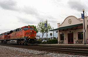
Corcoran station
Corcoran | |||||||||||||||||||||||||||
|---|---|---|---|---|---|---|---|---|---|---|---|---|---|---|---|---|---|---|---|---|---|---|---|---|---|---|---|
| Amtrak inter-city rail station | |||||||||||||||||||||||||||
 A BNSF intermodal train passes the station at Corcoran | |||||||||||||||||||||||||||
| Location |
1099 Otis Avenue Corcoran, California 93212[1] | ||||||||||||||||||||||||||
| Coordinates | 36°05′54″N 119°33′26″W / 36.0984°N 119.5571°WCoordinates: 36°05′54″N 119°33′26″W / 36.0984°N 119.5571°W | ||||||||||||||||||||||||||
| Owned by | City of Corcoran | ||||||||||||||||||||||||||
| Line(s) | |||||||||||||||||||||||||||
| Platforms | 1 side platform | ||||||||||||||||||||||||||
| Tracks | 2 | ||||||||||||||||||||||||||
| Connections | Kings Area Rural Transit | ||||||||||||||||||||||||||
| Construction | |||||||||||||||||||||||||||
| Structure type | At-grade | ||||||||||||||||||||||||||
| Parking | free | ||||||||||||||||||||||||||
| Disabled access | Yes | ||||||||||||||||||||||||||
| Other information | |||||||||||||||||||||||||||
| Station code | COC | ||||||||||||||||||||||||||
| History | |||||||||||||||||||||||||||
| Opened | October 2, 1999 | ||||||||||||||||||||||||||
| Traffic | |||||||||||||||||||||||||||
| Passengers (2015) |
32,331[2] | ||||||||||||||||||||||||||
| Services | |||||||||||||||||||||||||||
| |||||||||||||||||||||||||||
| Location | |||||||||||||||||||||||||||
 Location within California | |||||||||||||||||||||||||||
Corcoran is an unstaffed Amtrak train station in Corcoran, California, United States. Opened in 1999, it replaced a former Atchison, Topeka and Santa Fe Railway depot from 1907 that was demolished in 1998.[3] The current station exhibits Spanish Revival style architecture that includes decorative curvilinear gables and stuccoed walls. The depot is decorated with a large bas-relief called “Life of the Valley" depicting the importance of water to the residents, agriculture, and wildlife of the San Joaquin Valley.[3] Artist Garrett Masterson completed it with the help of his students at the nearby Corcoran State Prison.[3]
Although the next officially listed southbound station is Wasco, about 38 miles (61 km) southeast, Amtrak has another conditional flag stop about half way between at Colonel Allensworth State Historic Park in Earlimart.[4] Stops at the state park require preapproval and reservations several weeks in advance for groups of not less than 20 persons,[5] accordingly this station is not included on Amtrak's list of (active) stations[6]
Of the 73 California stations served by Amtrak, Corcoran was the 44th-busiest in FY2010, boarding or detraining an average of approximately 75 passengers daily.[7]
Platforms and tracks
| East track | ■ Freight line | No passenger service |
| West track | ■ San Joaquin | toward Oakland or Sacramento (Hanford) |
| ■ San Joaquin | toward Bakersfield (Colonel Allensworth State Historic Park or Wasco) |
References
- ↑ "Corcoran, CA (COC)". Amtrak. Retrieved 13 Sep 2013.
- ↑ "Amtrak Fact Sheet, FY2015, State of California" (PDF). Amtrak. November 2015. Retrieved 21 January 2016.
- 1 2 3 "Corcoran, CA (COC)". Amtrak. Retrieved 13 Sep 2013.
- ↑ "ALLENSWORTH State Historic Park CALIFORNIA (CNL)". trainweb.org. Retrieved 13 Sep 2013.
- ↑ "Colonel Allensworth SHP". California Department of Parks and Recreation. Retrieved 13 Sep 2013.
With a group of 20 or more (you will need a exact head count for preapproval), and several weeks ahead of time, Amtrak can stop at Allensworth and let you off right at the park.
- ↑ "Amtrak Station Codes: CA". Amtrak. Retrieved 13 Sep 2013.
- ↑ "Amtrak Fact Sheet, FY2010, State of California" (PDF). Amtrak. Nov 2010. Retrieved 6 Jan 2011.
External links
- Amtrak - Corcoran, CA (COC)
- Amtrak California - Corcoran (COC)
- Amtrak stations trainweb.org database
- Great American Stations: Corcoran, CA (COC)