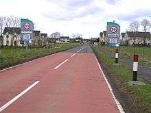
Drumsurn

Drumsurn (from Irish Droim Sorn, meaning "furnace ridge")[1] is a small village and townland in County Londonderry, Northern Ireland. It is 8 kilometres (5.0 mi) southeast of Limavady and 10 kilometres (6.2 mi) northeast of Dungiven. It lies in the Roe Valley, at the foot of Donald's Hill and at the edge of the Sperrins. Drumsurn had a population of 357 people in the 2001 Census. It is situated within Causeway Coast and Glens district.
Features
Drumsurn is mainly residential with educational, social, and recreational facilities. These include the high quality recreation grounds and community centre at St Matthew's GAC to the south of the village. There is a limited range of commercial services.[2] More than 95% of the village's population is Catholic.
The Troubles in Drumsurn
During the Troubles, loyalist paramilitaries exploded a car bomb outside O’Connor's Supply House in the centre of the village on 26 July 1973. There was considerable damage but no casualties.[3]
Places of interest
- Legavannon and Legananam Pot, unusual landscape features formed by glaciers, are near the village.[4][5]
- Kings Fort, one of the best preserved ráths in Northern Ireland, is nearby, but on private land.[4][5]
Sport
- Drumsurn GAC is the local Gaelic Athletic Association club.
Transport
- Drumsurn railway station opened on 4 July 1883, closed for passenger traffic on 1 January 1933 and finally closed altogether on 3 July 1950.[6]
Gallery

References
- ↑ Placenames Database of Ireland
- ↑ "Drumsurn Settlement Designation". Planning Service - Draft Northern Area Plan 2016. Retrieved 2008-06-22.
- ↑ "A Blast From The Past". A transcription from the (Coleraine) Chronicle. 28 July 1973. Retrieved 11 September 2012.
- 1 2 "Drumsurn". Limavady Borough Council. Retrieved 2008-06-22.
- 1 2 "Drumsurn". Culture Northern Ireland. Retrieved 2008-06-22.
- ↑ "Drumsurn station" (PDF). Railscot - Irish Railways. Retrieved 2007-10-12.
Coordinates: 54°59′N 6°53′W / 54.983°N 6.883°W
