East Africa Protectorate
| East Africa Protectorate | ||||||||||
| Dominion of the Sultan of Zanzibar and Protectorate of the British Empire | ||||||||||
| ||||||||||
| ||||||||||
| Anthem God Save the Queen/King | ||||||||||
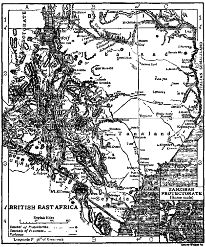
 Map of British East Africa in 1911. | ||||||||||
| Capital | Mombasa (1895–1905) Nairobi (1905–1920) | |||||||||
| Languages | English (official) Swahili, Gikuyu, Kamba, Luo, Gusii, Meru, Nandi–Markweta also spoken | |||||||||
| Religion | Christianity, Islam, Hinduism, traditional African religion | |||||||||
| Government | Constitutional monarchy | |||||||||
| Monarch | ||||||||||
| • | 1895–1901 | Victoria | ||||||||
| • | 1910–1920 | George V | ||||||||
| Commissioner, Governor | ||||||||||
| • | 1895–1897 | Arthur Henry Hardinge | ||||||||
| • | 1919–1920 | Sir Edward Northey | ||||||||
| History | ||||||||||
| • | Established | 1 July 1895 | ||||||||
| • | Disestablished | 23 July 1920 | ||||||||
| Area | ||||||||||
| • | 1904[1] | 696,447 km² (268,900 sq mi) | ||||||||
| Population | ||||||||||
| • | 1904[1] est. | 4,000,000 | ||||||||
| Density | 5.7 /km² (14.9 /sq mi) | |||||||||
| Currency | Rupee | |||||||||
| ||||||||||
| Today part of | | |||||||||
East Africa Protectorate (also known as British East Africa) was an area in the African Great Lakes occupying roughly the same terrain as present-day Kenya (approximately 639,209 km2 (246,800 sq mi)) from the Indian Ocean inland to Uganda and the Great Rift Valley. Although part of the dominions of the Sultan of Zanzibar, it was controlled by Britain in the late 19th century; it grew out of British commercial interests in the area in the 1880s and remained a protectorate until 1920 when it became the colony of Kenya, save for a 16-kilometre-wide (10 mi) coastal strip that became the Kenya protectorate.[2][3]
Administration
European missionaries began settling in the area from Mombasa to Mount Kilimanjaro in the 1840s, nominally under the protection of the Sultan of Zanzibar. In 1886, the British government encouraged William Mackinnon, who already had an agreement with the Sultan and whose shipping company traded extensively in the African Great Lakes, to establish British influence in the region. He formed a British East Africa Association which led to the Imperial British East Africa Company being chartered in 1888 and given the original grant to administer the dependency. It administered about 240 kilometres (150 mi) of coastline stretching from the River Jubba via Mombasa to German East Africa which were leased from the Sultan. The British "sphere of influence", agreed at the Berlin Conference of 1885, extended up the coast and inland across the future Kenya and after 1890 included Uganda as well. Mombasa was the administrative centre at this time.[4]
However, the company began to fail, and on 1 July 1895 the British government proclaimed a protectorate, the administration being transferred to the Foreign Office. In 1902 administration was again transferred to the Colonial Office and the Uganda territory was incorporated as part of the protectorate also. In 1897 Lord Delamere, the pioneer of white settlement, arrived in the Kenya highlands, which was then part of the Protectorate.[5] Lord Delamere was impressed by the agricultural possibilities of the area. In 1902, the boundaries of the Protectorate were extended to include what was previously the Eastern Province of Uganda.[5][6] Also, in 1902, the East Africa Syndicate received a grant of 1,300 square kilometres (500 sq mi) to promote white settlement in the Highlands. Lord Delamere now commenced extensive farming operations, and in 1905, when a large number of new settlers arrived from England and South Africa, the Protectorate was transferred from the authority of the Foreign Office to that of the Colonial Office.[5] The capital was shifted from Mombasa to Nairobi in 1905. A regular Government and Legislature were constituted by Order in Council in 1906.[7] This constituted the administrator a governor and provided for legislative and executive councils. Lieutenant Colonel J. Hayes Sadler was the first governor and commander in chief. There were occasional troubles with local tribes but the country was opened up by the Government and the colonists with little bloodshed.[5] After the First World War, more farmers arrived from England and South Africa, and by 1919 the European population was estimated at 9,000 settlers.[5]
On 23 July 1920, the inland areas of the Protectorate were annexed as British dominions by Order in Council.[8] That part of the former Protectorate was thereby constituted as the Colony of Kenya. The remaining 16-kilometre-wide (10 mi) coastal strip (with the exception of Witu), remained a Protectorate under an agreement with the Sultan of Zanzibar.[9] That coastal strip, remaining under the sovereignty of the Sultan of Zanzibar, was constituted as the Protectorate of Kenya in 1920.[3][4]
Development
After 1896, immigrants from India came to the area as money lenders, traders, and artisans. Racial segregation was normalised, with the Europeans assigning the Highlands to themselves. Other restrictions included commercial and residential segregation in the towns, and restrictions on Indian immigration. Nevertheless, the Indians rapidly grew to outnumber the Europeans by more than two to one by 1919. India was a crown colony whose citizens enjoyed certain privileges but it was unclear whether the Ishmael Indians in the African Great Lakes were to be recognised as citizens of the British Empire or as a subject race.
In April 1902, the first application for land in British East Africa was made by the East Africa Syndicate – a company in which financiers belonging to the British South Africa Company were interested – which sought a grant of 1,300 square kilometres (500 sq mi), and this was followed by other applications for considerable areas, including a large Jewish settlement. In April 1903, Major Frederick Russell Burnham, the famous American scout and then a Director of the East African Syndicate, sent an expedition consisting of John Weston Brooke, John Charles Blick, Mr. Bittlebank and Mr. Brown, to assess the mineral wealth of the region. The party, known as the "Four B.'s", travelled from Nairobi via Mount Elgon northwards to the western shores of Lake Rudolph, experiencing plenty of privations from want of water, and of the danger from encounters with the Maasai.[10] With the arrival in 1903 of hundreds of prospective settlers, chiefly from South Africa, questions were raised concerning the preservation for the Maasai of their rights of pasturage, and the decision was made to entertain no more applications for large areas of land.
In the process of carrying out this policy of colonisation a dispute arose between Sir Charles Eliot, then Commissioner of British East Africa and Lord Lansdowne, the British Foreign Secretary. Lansdowne, believing himself bound by pledges given to the East Africa Syndicate, decided that they should be granted the lease of the 1,300 square kilometres (500 sq mi) they had applied for; but after consulting officials of the protectorate then in London, he refused Eliot permission to conclude leases for 130 square kilometres (50 sq mi) each to two applicants from South Africa. Eliot thereupon resigned his post, and in a public telegram to the Prime Minister, dated Mombasa, 21 June 1904, gave as his reason: "Lord Lansdowne ordered me to refuse grants of land to certain. private persons while giving a monopoly of land on unduly advantageous terms to the East Africa Syndicate. I have refused to execute these instructions, which I consider unjust and impolitic." On the day Sir Charles sent this telegram the appointment of Sir Donald William Stewart, the chief commissioner of Ashanti (Ghana), to succeed him was announced.
Stamps and postal history of British East Africa

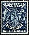
The territory had its own mail system during the 1890s; see Postage stamps and postal history of British East Africa for further details.
See also
- Sir Charles Eliot
- Colonial Heads of Kenya
- East African Campaign (World War I)
- History of Kenya
- East Africa and Uganda Protectorates
- Impact of Western European colonialism and colonisation
Notes
- 1 2 "Census of the British empire. 1901". Openlibrary.org. 1906. p. 178. Retrieved 26 December 2013.
- ↑ British East Africa Company
- 1 2 Kenya Protectorate Order in Council, 1920 S.R.O. 1920 No. 2343, S.R.O. & S.I. Rev. VIII, 258, State Pp., Vol. 87 p. 968
- 1 2 British East Africa, by Grant Sinclair
- 1 2 3 4 5 "Commonwealth and Colonial Law" by Kenneth Roberts-Wray, London, Stevens, 1966. P. 761
- ↑ East Africa Order in Council, 1902, S.R.O. 1902 No. 661, S.R.O. ^ S.I. Rev. 246
- ↑ "Commonwealth and Colonial Law" by Kenneth Roberts-Wray, London, Stevens, 1966. P. 762
- ↑ Kenya (Annexation) Order in Council, 1920, S.R.O. 1902 No. 661, S.R.O. & S.I. Rev. 246.
- ↑ Agreement of 14 June 1890: State pp. vol. 82. p. 653
- ↑ Fergusson, W.N. (1911). Adventure, Sport and Travel on the Tibetan Steppes, p. preface. Charles Scribner's Sons, New York
References
Further reading
- John S. Galbraith, Mackinnon and East Africa 1878–1895 (Cambridge 1972)
- Map of British East Africa in 1901
- A map of part of Eastern Africa, prepared by authority of the Imperial British East Africa Company, 1889
- 1911 Encyclopedia

.svg.png)
