Adrianople Vilayet
| ولايت ادرنه Vilâyet-i Edirne | |||||
| Vilayet of the Ottoman Empire | |||||
| |||||
.png) | |||||
| Capital | Edirne[1] | ||||
| History | |||||
| • | Established | 1867 | |||
| • | Disestablished | 1922 | |||
| Population | |||||
| • | Muslim, 1914[2] | 360,411 | |||
| • | Greek, 1914[2] | 224,680 | |||
| • | Armenian, 1914[2] | 19,773 | |||
| • | Jewish, 1914[2] | 22,515 | |||
| Today part of | | ||||
The Vilayet of Adrianople or Vilayet of Edirne (Ottoman Turkish: ولايت ادرنه, Vilâyet-i Edirne)[3] was a first-level administrative division (vilayet) of the Ottoman Empire.
This vilayet was split between Turkey and Greece in 1923, culminating in the formation of Western and Eastern Thrace after World War I as part of the Treaty of Lausanne. A small portion of the Vilayet was given to Bulgaria in the Treaty of Bucharest (1913) after the Balkan wars. In the late 19th century it reportedly had an area of 26,160 square miles (67,800 km2).[4] In the east it bordered with the Istanbul Vilayet, the Black Sea and the Sea of Marmara, in the west with the Salonica Vilayet, in the north with Eastern Rumelia (Bulgaria since 1885) and in the south with the Aegean Sea. Sometimes the area is described also as Southern Thrace,[5] or Adrianopolitan Thrace.[6]
After the city of Edirne (pop. in 1905 about 80,000), the principal towns were Tekirdağ (35,000), Gelibolu (25,000), Kırklareli (16,000), İskeçe (14,000), Çorlu (11,500), Dimetoka (10,000), Enez (8000), Gümülcine (8000) and Dedeağaç (3000).[7]
Administrative divisions
Sanjaks of the Vilayet:[8]
- Sanjak of Edirne (Edirne, Cisr-i Mustafapaşa, Kırcaali, Dimetoka, Ortaköy, Cisr-i Ergene, Havsa. It had also kazas of Kırkkilise, Baba-yı Atik, Beykar Hisar, Maa Hatunili-Kızılağaç (Its centre was Kızılağaç) and Ferecik. Kızılağaç went to Yanbolu sanjak of Şarki Rumeli Vilayeti, Ferecik went initially to Gelibolu in 1876, later to Dedeağaç and was demoted to nahiya in 1878, Kırkkilise, Baba-yı Atik and Beykar Hisar went to recreated Kırkkilise sanjak in 1878. Beykar Hisar was demoted to nahiya in 1879)
- Sanjak of Kirklareli (Since 1879) (Kirkkilise) (Kırkkilise, Tırnovacık, Lüleburgaz, Vize, Ahtabolu, Midye, Baba-yı Atik. Saray separated from Vize and became kaza in 1916)
- Sanjak of Tekirdag (Tekfurdagi) (Tekfurdağı, Çorlu, Malkara, Hayrabolu. It had also kazas Vize, Lüleburgaz and Midye till 1879, it was gone to recreated Kırkkilise sanjak)
- Sanjak of Gelibolu (Gelibolu, Maydos, Şarköy, Mürefte, Keşan. It had also Enez and Gümülcine kazas till 1878. Gümülcine promoted to sanjak in 1878. Enez went to Dedeağaç sanjak. Finally İpsala (promoted to kaza) and Enez returned to Gelibolu in 1913)
- Sanjak of Dedeağaç (1878-1912) (Dedeağaç, Sofulu, Enez)
- Sanjak of Gümülcine (1878-1912) (Gümülcine, İskeçe, Koşukavak, Ahiçelebi, Eğridere, Darıdere)
- Sanjak of Filibe (Filibe, Pazarcık, Hasköy, Zağra-i Atik, Kızanlık, Çırpan, Sultanyeri, Ahiçelebi) (until 1878, then it became part of Eastern Rumelia)
- Sanjak of Slimia (İslimye, Yanbolu, Misivri, Karinabat, Aydos, Zağra-i Cedid, Ahyolu, Burgaz) (until 1878, then became part of Eastern Rumelia)
Demographics
Population of the groups of the Vilayet and Sanjaks according to the Ottoman census in 1906/7, in thousands, adjusted to round numbers.[9] The groups are counted according to the Millet System of the Ottoman Empire not according to the mother tongue, some Bulgarian-speakers were part of the Greek Rum millet and counted as Greeks, while the Muslim millet included Turks and Pomaks (Bulgarian speaking Muslims).
| Groups | Edirne | Gümülcine | Kırklareli | Dedeağac | Tekirdağ | Gelibolu | Total |
|---|---|---|---|---|---|---|---|
| Muslims | 154 | 240 | 78 | 44 | 77 | 26 | 619 |
| Greeks | 103 | 22 | 71 | 28 | 53 | 65 | 341 |
| Bulgarians | 37 | 29 | 30 | 17 | 6 | 1 | 120 |
| Jews | 16 | 1 | 2 | - | 3 | 2 | 24 |
| Armenians | 5 | - | - | - | 19 | 1 | 26 |
| Others | 2 | - | - | - | 1 | - | 2 |
| Total | 317 | 292 | 181 | 89 | 159 | 96 | 1,134 |
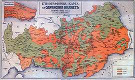
A publication from December 21, 1912 in the Belgian magazine Ons Volk Ontwaakt (Our Nation Awakes) estimated 1,006,500 inhabitants:[10]
- Muslim Turks - 250,000
- Muslim Bulgarians - 115,000
- Muslim Roma people - 15,000
- Orthodox Armenians - 30,000
- Orthodox Greeks - 220,000
- Orthodox Bulgarians - 370,000
- Orthodox Albanians - 3,500
- Orthodox Turks - 3,000
Gallery
-
.jpg)
1907 Ottoman Turkish map of the vilayet
-

Ethnic map of 1912 according to Bulgarian ethnographers
References
- ↑ Encyclopaedia Britannica 1911 Edition, Adrianople. Archived May 25, 2011, at the Wayback Machine.
- 1 2 3 4 "1914 Census Statistics" (PDF). Turkish General Staff. pp. 605–606. Retrieved 29 January 2011.
- ↑ Salname-yi Vilâyet-i Edirne ("Yearbook of the Vilayet of Edirne"), Edirne vilâyet matbaası, Edirne, 1300 [1882]; on the website of Hathi Trust Digital Libray.
- ↑ Europe by Éliseé Reclus, page 152
- ↑ Migration, Memory, Heritage: Socio-cultural Approaches to the Bulgarian-turkish Border, Magdalena Elchinova, Valentina Ganeva-Raycheva, Lina Gergova, Stoyka Penkova, Natalia Rashkova, Nikolai Vukov, Meglena Zlatkova, Lina Gergova, ISBN 954845842X, p. 30.
- ↑ Europe and the Historical Legacies in the Balkans, Raymond Detrez, Barbara Segaert, Peter Lang, 2008, ISBN 9052013748, p. 58.
- ↑ Wikisource - 1911 Encyclopædia Britannica - Adrianople (vilayet)
- ↑ Edirne Vilayeti | Tarih ve Medeniyet
- ↑ Ottoman Population, 1830-1914: Demographic and Social Characteristics, Kemal H. Karpat, page 91, 1985
- ↑ Published on December 21, 1912 in the Belgian magazine Ons Volk Ontwaakt (Our Nation Awakes) - view the table of Vilajet Manastir: Skynet GodsdBalkan
External links
| Wikimedia Commons has media related to Adrianople Vilayet. |
![]() "Adrianople (vilayet)". Encyclopædia Britannica (11th ed.). 1911.
"Adrianople (vilayet)". Encyclopædia Britannica (11th ed.). 1911.
