Eiken, Norway
| Eiken herred | |
|---|---|
| Former Municipality | |
|
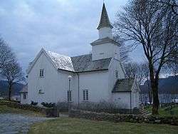
View of the municipal church | |
 Eiken herred  Eiken herred Location of the municipality | |
| Coordinates: 58°28′44″N 07°12′43″E / 58.47889°N 7.21194°ECoordinates: 58°28′44″N 07°12′43″E / 58.47889°N 7.21194°E | |
| Country | Norway |
| Region | Southern Norway |
| County | Vest-Agder |
| District | Lister |
| Municipality ID | NO-1035 |
| Adm. Center | Eiken |
| Time zone | CET (UTC+01:00) |
| • Summer (DST) | CEST (UTC+02:00) |
| Created from | Hægebostad in 1916 |
| Merged into | Hægebostad in 1963 |
Eiken is a former municipality in Vest-Agder county, Norway. The municipality existed from 1916 until its dissolution in 1963. It was located in the northern half of the present-day municipality of Hægebostad. The administrative centre was the village of Eiken where Eiken Church is located. The municipality included the far northern end of the Lyngdalen valley from the lake Lygne to the mountains in the north.[1]
Name
The municipality (originally the parish) is named after the old Eiken farm (Old Norse: Æke). The name of the farm means "oak tree".[2]
History
The municipality of Eiken was established on 1 January 1916 when the municipality of Hægebostad was divided into two separate municipalities: Eiken (population: 932) and Hægebostad (population: 867). On 1 January 1963, the two municipalities were reunited and together formed the municipality of Hægebostad. Before the merger the population of Eiken was 784.[3]
See also
References
- ↑ Store norske leksikon. "Eiken – tidligere kommune" (in Norwegian). Retrieved 2016-10-24.
- ↑ Rygh, Oluf (1912). Norske gaardnavne: Lister og Mandals amt (in Norwegian) (9 ed.). Kristiania, Norge: W. C. Fabritius & sønners bogtrikkeri. p. 264.
- ↑ Jukvam, Dag (1999). "Historisk oversikt over endringer i kommune- og fylkesinndelingen" (PDF) (in Norwegian). Statistisk sentralbyrå.
External links
- Weather information for Eiken (Norwegian)
