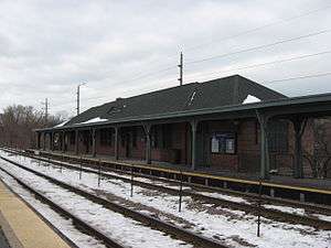
Evanston Central Street station
 | |||||||||||
| Location |
1826 Central Street Evanston, Illinois 60201 | ||||||||||
| Owned by | Union Pacific | ||||||||||
| Line(s) | |||||||||||
| Platforms | 2 side platforms | ||||||||||
| Tracks | 2 | ||||||||||
| Connections |
| ||||||||||
| Construction | |||||||||||
| Disabled access | Yes | ||||||||||
| Other information | |||||||||||
| Fare zone | C | ||||||||||
| History | |||||||||||
| Opened | 1911 | ||||||||||
| Services | |||||||||||
| |||||||||||
Evanston Central Street is the northernmost of the three commuter railroad stations in Evanston, Illinois, United States. It is an elevated station at Green Bay Road and Central Street, surrounded by a neighborhood of stores, restaurants and multi-story apartment buildings. Just north of the station, the tracks descend to grade and pass through Wilmette on ground level.
Evanston Central Street station is served by Metra's Union Pacific/North Line, with service south to Ogilvie Transportation Center in Chicago and as far north as Kenosha, Wisconsin. The station is 13.3 miles (21.4 km) from Ogilvie Transportation Center.[1] In Metra's zone-based fare system, Evanston Central Street is in zone C. There are two platforms: northbound trains stop at the west platform, and southbound trains stop at the east platform. Evanston Central Street has a station house on the east platform. The station house contains a ticket booth as well as a coffee and pastry shop named "Upstairs Cafe" owned and run by three Evanston women, two of whom are professional bakers.[2] The station house is open from 5:15 a.m. to 1:15 p.m. and a ticket agent is present during these hours on weekdays.
This is the closest Metra station to Northwestern University's sports complex at Ryan Field. The 15th hold fairway and 16th hole tee box of the Canal Shores Golf Course adjoin this Metra station.[3] Chicago Transit Authority's Central station on the Purple Line is less than a mile to the east.
A highly unusual incident occurred at this station on August 23, 2006, when a train bound from Kenosha to Chicago ran out of fuel, apparently due to employee error.[4]
Bus connections
- 201 Central/Ridge
- 206 Evanston Circulator
- 213 Green Bay Road
References
- ↑ Metra Railfan Tips - Union Pacific/North Line
- ↑ "Security Check Required". www.facebook.com. Retrieved 2016-03-23.
- ↑ http://ewcgolf.org/scorecard/
- ↑ Metra: Rail worker failed to fill 'er up - Chicago Tribune, 25 August 2006
External links
 Media related to Evanston Central Street station at Wikimedia Commons
- Lincoln Street entrance from Google Maps Street View
- Central Street entrance from Google Maps Street View
Coordinates: 42°03′50″N 87°41′53″W / 42.063964°N 87.698041°W