False Bay (Livingston Island)
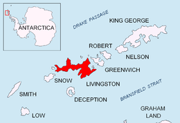

False Bay (62°43′S 60°22′W / 62.717°S 60.367°WCoordinates: 62°43′S 60°22′W / 62.717°S 60.367°W) is a bay 4 miles (6.4 km) long, which lies between Barnard Point and Miers Bluff on the south side of Livingston Island, in the South Shetland Islands, Antarctica. The glaciers Hurd Ice Cap, Huntress, Ruen Icefall, Peshtera and Charity feed the bay.
It was probably first entered and charted by Captain Nathaniel Palmer in November 1820, and was likely named because of the possibility in thick weather of confusion between this feature and nearby South Bay, where Johnsons Dock was frequented by the early sealers.[1]
Maps
- South Shetland Islands. Scale 1:200000 topographic map No. 5657. DOS 610 – W 62 60. Tolworth, UK, 1968.
- Islas Livingston y Decepción. Mapa topográfico a escala 1:100000. Madrid: Servicio Geográfico del Ejército, 1991.
- L.L. Ivanov. Antarctica: Livingston Island and Greenwich, Robert, Snow and Smith Islands. Scale 1:120000 topographic map. Troyan: Manfred Wörner Foundation, 2009.
- Antarctic Digital Database (ADD). Scale 1:250000 topographic map of Antarctica. Scientific Committee on Antarctic Research (SCAR), 1993–2016.
References
- ↑ "False Bay". Geographic Names Information System. United States Geological Survey. Retrieved 2012-03-13.
![]() This article incorporates public domain material from the United States Geological Survey document "False Bay" (content from the Geographic Names Information System).
This article incorporates public domain material from the United States Geological Survey document "False Bay" (content from the Geographic Names Information System).