Frazee, Minnesota
| Frazee, Minnesota | |
|---|---|
| City | |
|
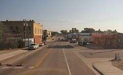
Downtown Frazee | |
| Motto: "Home Of The World's Largest Turkey" | |
| Coordinates: 46°43′42″N 95°42′4″W / 46.72833°N 95.70111°W | |
| Country | United States |
| State | Minnesota |
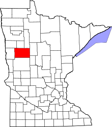
| County | Becker |
| Government | |
| • Mayor | Hank Ludtke |
| Area[1] | |
| • Total | 1.11 sq mi (2.87 km2) |
| • Land | 1.06 sq mi (2.75 km2) |
| • Water | 0.05 sq mi (0.13 km2) |
| Elevation | 1,388 ft (423 m) |
| Population (2010)[2] | |
| • Total | 1,350 |
| • Estimate (2012[3]) | 1,367 |
| • Density | 1,273.6/sq mi (491.7/km2) |
| Time zone | CST (UTC-6) |
| • Summer (DST) | CDT (UTC-5) |
| ZIP codes | 56544 |
| Area code(s) | 218 |
| FIPS code | 27-22472[4] |
| GNIS feature ID | 0643899[5] |
| Website | www.frazeecity.com |
Frazee (/freɪˈziː/ fray-ZEE) is a city in Becker County, Minnesota, United States. It is the second most populous city in Becker County. The population was 1,350 at the 2010 census.[6] It was named Detroit and later Third Crossing before adopting its name of Frazee. With Becker County not formally organized until 1871, it was the earliest settlement in the area. The city was officially incorporated on January 6, 1891. It was named after R. L. Frazee, owner of a sawmill.[7] Today it is best known as the home of "Big Tom: the World's Largest Turkey."[8]
Geography
According to the United States Census Bureau, the city has a total area of 1.11 square miles (2.87 km2), of which, 1.06 square miles (2.75 km2) is land and 0.05 square miles (0.13 km2) is water.[1]
Frazee is located 46.8 degrees north of the equator and 95.8 degrees west of the prime meridian. Altitude is 1,274 feet (388 m) above sea level.
U.S. Route 10 and Minnesota State Highway 87 are two of the main routes in the city.
Demographics
| Historical population | |||
|---|---|---|---|
| Census | Pop. | %± | |
| 1880 | 97 | — | |
| 1900 | 1,000 | — | |
| 1910 | 1,645 | 64.5% | |
| 1920 | 1,277 | −22.4% | |
| 1930 | 1,041 | −18.5% | |
| 1940 | 1,167 | 12.1% | |
| 1950 | 1,021 | −12.5% | |
| 1960 | 1,083 | 6.1% | |
| 1970 | 1,015 | −6.3% | |
| 1980 | 1,284 | 26.5% | |
| 1990 | 1,176 | −8.4% | |
| 2000 | 1,377 | 17.1% | |
| 2010 | 1,350 | −2.0% | |
| Est. 2015 | 1,371 | [9] | 1.6% |
| U.S. Decennial Census | |||
2010 census
As of the census[2] of 2010, there were 1,350 people, 540 households, and 325 families residing in the city. The population density was 1,273.6 inhabitants per square mile (491.7/km2). There were 595 housing units at an average density of 561.3 per square mile (216.7/km2). The racial makeup of the city was 88.1% White, 1.6% African American, 5.1% Native American, 0.6% Asian, 0.2% from other races, and 4.4% from two or more races. Hispanic or Latino of any race were 2.4% of the population.
There were 540 households of which 34.1% had children under the age of 18 living with them, 41.1% were married couples living together, 13.3% had a female householder with no husband present, 5.7% had a male householder with no wife present, and 39.8% were non-families. 34.1% of all households were made up of individuals and 16.3% had someone living alone who was 65 years of age or older. The average household size was 2.39 and the average family size was 3.00.
The median age in the city was 36.7 years. 25.9% of residents were under the age of 18; 8.1% were between the ages of 18 and 24; 24.2% were from 25 to 44; 23.5% were from 45 to 64; and 18.5% were 65 years of age or older. The gender makeup of the city was 45.4% male and 54.6% female.
2000 census

As of the census[4] of 2000, there were 1,377 people, 504 households, and 318 families residing in the city. The population density was 1,593.2 people per square mile (618.2/km²). There were 553 housing units at an average density of 639.8 per square mile (248.3/km²). The racial makeup of the city was 93.39% White, 0.65% African American, 2.98% Native American, 0.94% Asian, 0.36% from other races, and 1.67% from two or more races. Hispanic or Latino of any race were 0.94% of the population.
There were 504 households out of which 34.5% had children under the age of 18 living with them, 43.3% were married couples living together, 15.9% had a female householder with no husband present, and 36.9% were non-families. 31.5% of all households were made up of individuals and 17.3% had someone living aloe who was 65 years of age or older. The average household size was 2.51 and the average family size was 3.16.
In the city the population was spread out with 27.7% under the age of 18, 11.4% from 18 to 24, 23.2% from 25 to 44, 16.3% from 45 to 64, and 21.5% who were 65 years of age or older. The median age was 36 years. For every 100 females there were 82.4 males. For every 100 females age 18 and over, there were 79.5 males.
The median income for a household in the city was $26,150, and the median income for a family was $31,576. Males had a median income of $27,153 versus $18,875 for females. The per capita income for the city was $12,257. About 14.7% of families and 19.0% of the population were below the poverty line, including 21.4% of those under age 18 and 33.9% of those age 65 or over.
Government
The City of Frazee is governed by the Statutory City Plan A form of government (in Minnesota, 601 cities operate under Plan A). One of the features of this plan is that it removes the clerk from the council and replaces that position with a fourth (or sixth) elected council member. Another feature is that the council appoints the clerk and treasurer for indefinite terms of office. A mayor and four council members are elected to three-year terms. Current mayor Hank Ludke was elected to office in January 2007. The city council meets every Monday at 7:00 PM CDT in the Fire Hall.[8]
Business and industry
The three largest employers in Frazee are Frazee-Vergas Public Schools (160 employees), Frazee Care Center (160), and Daggett Truck Line (102). Daggett Truck Line has been operating for 80 years out of Frazee, carrying refrigerated and dry freight throughout the United States and southern Canada. The company transports frozen foods, snack foods, pet food, produce and manufactured goods from Minnesota to most major cities in the midwest and throughout the United States. These trucks return with processed foods or raw materials for local manufacturers.[10]
The world's largest turkey
Original statue
Frazee has long been a part of the turkey industry. In 1984, turkey growers and committee members got together and decided to put up a giant turkey statue to honor the town. At the cost of $20,000 to build, the group commissioned artist Shell Scott to construct the statue which was built on a metal frame and covered in cement, fiberglass, cardboard, and insulation. The statue, named "Big Tom", was finished in 1986 and stood 22 feet (6.7 m) tall earning Frazee the title of "Home of the world's largest turkey."
Due to Big Tom's physical makeup, the statue needed frequent repairs. There were also complaints that Big Tom was not proportioned like a real turkey. The area committee decided that they needed a new Big Tom and commissioned artist Dave Oswald. On July 1, 1998, during the removing process for Big Tom, the statue caught fire from a cutting torch, which was being used to remove the wings.
New statue
On September 19, 1998, a new statue arrived in Frazee in three pieces on a flatbed trailer. The new "Big Tom" took eight hours to assemble, standing over 20 feet (6.1 m) tall and 17 feet (5.2 m) wide. It weighs over 5,000 pounds, having 1,000 pounds of steel reinforcement. It has 3,000 to 4,000 separate fiberglass feathers, which took the D.W.O. Fiberglass Company over 2,000 hours to make.
References
- 1 2 "US Gazetteer files 2010". United States Census Bureau. Retrieved 2012-11-13.
- 1 2 "American FactFinder". United States Census Bureau. Retrieved 2012-11-13.
- ↑ "Population Estimates". United States Census Bureau. Retrieved 2013-05-28.
- 1 2 "American FactFinder". United States Census Bureau. Retrieved 2008-01-31.
- ↑ "US Board on Geographic Names". United States Geological Survey. 2007-10-25. Retrieved 2008-01-31.
- ↑ "2010 Census Redistricting Data (Public Law 94-171) Summary File". American FactFinder. U.S. Census Bureau, 2010 Census. Retrieved 23 April 2011.
- ↑ Upham, Warren (1920). Minnesota Geographic Names: Their Origin and Historic Significance. Minnesota Historical Society. p. 28.
- 1 2 "Official Website for the City of Frazee, Minnesota".
- ↑ "Annual Estimates of the Resident Population for Incorporated Places: April 1, 2010 to July 1, 2015". Retrieved July 2, 2016.
- ↑ "Daggett Truck Line website".
External links
Coordinates: 46°43′41″N 95°42′03″W / 46.72806°N 95.70083°W

