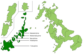
Fukue Island
Coordinates: 32°41′N 128°45′E / 32.683°N 128.750°E

Fukue Island (福江島 Fukue-jima) is the largest and southernmost of the Gotō Islands in Japan.[1] It is part of the city of Gotō in Nagasaki Prefecture. Gotō-Fukue Airport is on this island.
Climate
Fukue has a generally warm and very wet climate (Köppen Cfa) with hot and oppressively humid summers and cool, wet winters with practically no snowfall owing to the island’s southerly latitude. Despite this, during the winter months cold water transported south from the Sea of Okhotsk by the eastern side of the Siberian High makes for very gloomy weather with scarcely any more sunshine than the “San‘in” coast from Hagi to Wakkanai. Like the rest of Kyūshū, Fukue and the other Gotō Islands are prone to typhoons during summer and autumn which can give daily rainfalls as high as 432.5 millimetres (17.0 in) on 10 September 2005 and 433.5 millimetres (17.1 in) on 7 July 1987. The wettest month on record was July 1987 with 872 millimetres (34 in) and the driest was November 1971 with 3.5 millimetres (0.1 in).
| Climate data for Fukue (1981~2010) | |||||||||||||
|---|---|---|---|---|---|---|---|---|---|---|---|---|---|
| Month | Jan | Feb | Mar | Apr | May | Jun | Jul | Aug | Sep | Oct | Nov | Dec | Year |
| Record high °C (°F) | 20.9 (69.6) |
22.2 (72) |
23.0 (73.4) |
26.7 (80.1) |
31.5 (88.7) |
32.9 (91.2) |
35.4 (95.7) |
34.6 (94.3) |
32.9 (91.2) |
30.5 (86.9) |
26.6 (79.9) |
23.7 (74.7) |
35.4 (95.7) |
| Average high °C (°F) | 10.6 (51.1) |
11.5 (52.7) |
14.4 (57.9) |
18.8 (65.8) |
22.7 (72.9) |
25.6 (78.1) |
29.3 (84.7) |
30.6 (87.1) |
27.7 (81.9) |
23.2 (73.8) |
18.2 (64.8) |
13.3 (55.9) |
20.5 (68.9) |
| Average low °C (°F) | 3.9 (39) |
4.2 (39.6) |
6.5 (43.7) |
10.3 (50.5) |
14.5 (58.1) |
18.7 (65.7) |
23.4 (74.1) |
24.0 (75.2) |
20.7 (69.3) |
15.3 (59.5) |
10.2 (50.4) |
5.7 (42.3) |
13.1 (55.6) |
| Record low °C (°F) | −4.1 (24.6) |
−5.4 (22.3) |
−2.4 (27.7) |
0.3 (32.5) |
5.3 (41.5) |
10.4 (50.7) |
15.7 (60.3) |
17.4 (63.3) |
10.4 (50.7) |
5.2 (41.4) |
1.3 (34.3) |
−1.6 (29.1) |
−5.4 (22.3) |
| Average rainfall mm (inches) | 98.9 (3.894) |
105.9 (4.169) |
184.1 (7.248) |
236.7 (9.319) |
243.9 (9.602) |
317.5 (12.5) |
314.2 (12.37) |
234.5 (9.232) |
284.7 (11.209) |
108.8 (4.283) |
119.7 (4.713) |
86.9 (3.421) |
2,335.8 (91.96) |
| Average rainy days (≥ 0.5 mm) | 13.0 | 10.5 | 12.7 | 11.0 | 10.6 | 13.3 | 11.9 | 11.2 | 10.9 | 6.8 | 10.2 | 11.6 | 133.7 |
| Average relative humidity (%) | 66 | 66 | 68 | 72 | 76 | 82 | 84 | 81 | 77 | 70 | 68 | 67 | 73.1 |
| Mean monthly sunshine hours | 81.2 | 103.2 | 141.9 | 172.6 | 184.5 | 133.7 | 160.3 | 199.2 | 166.6 | 179.3 | 130.5 | 103.1 | 1,756.1 |
| Source #1: Japan Meteorological Agency[2] | |||||||||||||
| Source #2: Japan Meteorological Agency (records)[3] | |||||||||||||
References
| Wikimedia Commons has media related to Fukuejima. |
- ↑ "Nagasaki, Unzen, Goto Islands, Iki and Tsushima" (PDF). Japan National Tourist Organization. 2007.
- ↑ "平年値(年・月ごとの値)". Japan Meteorological Agency. Retrieved 2011-11-26.
- ↑ "観測史上1~10位の値(年間を通じての値)". Japan Meteorological Agency. Retrieved 2011-11-26.