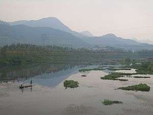
Fushui River

The Fushui River (富水) is a river flowing through Tongshan and Yangxin Counties in the south-eastern part of Hubei province, People's Republic of China.
The river is 196 kilometres (122 mi) long. It originates in the Mufu Mountains, flows in the general eastern direction, and discharges into the Yangtze River[1] near Fuchi Town, Yangxin County (29°51′38″N 115°26′28″E / 29.86056°N 115.44111°ECoordinates: 29°51′38″N 115°26′28″E / 29.86056°N 115.44111°E).
There are a number of dams on the river and its tributaries. The most major or them, the Fushui Dam (富水大坝; 29°41′26″N 114°53′17″E / 29.69056°N 114.88806°E) is located in Yangxin County just east of the Tongshan County's county line. The dam creates a fairly large Fushui Reservoir (富水水库).
The Xianning Nuclear Power Plant is under construction in Dafan Town, Tongshan County, on the northern shore of the Fushui Reservoir (29°40′20″N 114°41′05″E / 29.67222°N 114.68472°E);[2] it is expected to use the reservoir's water for cooling and various ancillary purposes.[3]
China National Highway 316 runs alongside the river for parts of its length.

References
- ↑ "Sediment sources and the flood record from Wanghu lake, in the middle reaches of the Yangtze River". Journal of Hydrology. 329: 568–576. October 15, 2006. doi:10.1016/j.jhydrol.2006.03.008. Retrieved October 22, 2008.
- ↑ 咸宁核电有限公司概况 (Briefly about Xianning Nuclear Power Ltd.). The location given in the article - near the Lion Cliff, in Dafan Town's Dakan Village (通山县大畈镇大墈村附近的狮子岩) can be found on maps.sogou.com, and the lay of the land on the mockup picture matches the peninsula of the satellite view on Google Maps.
- ↑ 咸宁大畈核电公司专程洽商富水水库取水事项 ("Xianning Dafan Nuclear Power company makes a special trip to negotiate Fushui Reservoir water use issues"), Fushui Reservoir Management Company, 2010-10-23]
External links
- 湖北省富水水库管理局 (The administration of Fushui Reservoir, Hubei Province) - the official site (Chinese)
| Wikimedia Commons has media related to Fushui River. |