Hamano Station
Hamano Station 浜野駅 | |
|---|---|
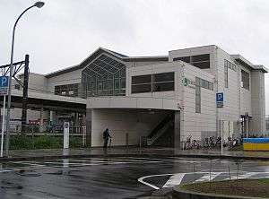
 East Exit of Hamano Station | |
| Location |
Hamanochō 700, Chūō, Chiba, Chiba (千葉県千葉市中央区浜野町700) Japan |
| Operated by | East Japan Railway Company |
| Line(s) | Uchibō Line |
| Connections |
|
| History | |
| Opened | 1912 |
| Traffic | |
| Passengers (2009) | 6,279 daily |
Hamano station (浜野駅 Hamano-eki) is a railway station operated by JR East's Uchibō Line located in Chūō-ku, Chiba. Chiba Prefecture, Japan. It is 3.4 kilometers from the terminus of the Uchibō Line at Soga Station.
History
Hamano Station was opened on March 28, 1912 as a station on the Japanese Government Railways (JGR) Kisarazu Line. On May 24, 1919, the line's name changed to the Hōjō Line, and on April 15, 1929 to the Bōsō Line and on April 1, 1933 to the Bōsōnishi Line. It became part of the Japan National Railways (JNR) after World War II, and the line was renamed the Uchibō Line from July 15, 1972. The station assumed its present name from March 31, 1974. Hamano Station was absorbed into the JR East network upon the privatization of the Japan National Railways (JNR) on April 1, 1987. After schedule changes from December 2007, express trains connecting directly to the Keiyō Line and Sōbu Line also stop at this station. The platform length was extended from November 2007 to facilitate stopping of high speed trains.
Lines
Station layout
Hamano station is an above-ground station with an elevated station building, and has two sets of tracks running around an island platform. The station has east and west exits, and has MARS computer terminals, automatic ticket machines, and automatic ticket gates.
Platforms
| 1 | ■ Uchibō Line | For Soga, Chiba, Tokyo |
| 2 | ■ Uchibō Line | For Goi, Kisarazu, Kimitsu, Tateyama |
Surroundings
- National Highway Route 16
- starting point of National Highway Route 357
- Chiba Prefectural Oihama High School
- Chiba Municipal Oihama Elementary School
- Chiba Municipal Oihama West Elementary School
- Chiba Municipal Oihama East Elementary School
- Hamano Kindergarten
Adjacent stations
| « | Service | » | ||
|---|---|---|---|---|
| Uchibō Line | ||||
| Soga | Commuter Rapid | Yawatajuku | ||
| Soga | Rapid (Sobu Line) |
Yawatajuku | ||
| Soga | Rapid (Keiyō Line) |
Yawatajuku | ||
| Soga | Local | Yawatajuku | ||
External links
- (Japanese) JR East Station information
Coordinates: 35°33′07″N 140°07′56″E / 35.5519°N 140.1323°E