Hamford Water
| Site of Special Scientific Interest | |
 | |
| Area of Search | Essex |
|---|---|
| Grid reference | TM 235255 |
| Interest | Biological |
| Area | 2185.8 hectares |
| Notification | 1986 |
| Location map | Magic Map |
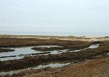
Hamford Water is a 2185.8 biological Site of Special Scientific Interest between Walton-on-the-Naze and Harwich in Essex.[1][2] It is also a Ramsar site,[3] a Special Protection Area,[4] a Nature Conservation Review site, and most of it is a National Nature Reserve.[5] Two small areas, Skipper's Island and John Weston Nature Reserve, are managed by the Essex Wildlife Trust.[6][7] The largest island, Horsey Island, can be reached on foot at low tide across The Wade from Kirby-le-Soken.
The site is a tidal inlet which has marsh grasslands, creeks, mud and sand flats, salt marshes, islands and beaches. It is described by Natural England as "of international importance for breeding little terns and wintering dark-bellied brent geese, wildfowl and waders, and of national importance for many other bird species." Rare plants include hog's fennel and slender hare's-ear. The main invertebrates are worms and thin-shelled molluscs.[1]
| Wikimedia Commons has media related to Hamford Water. |
References
- 1 2 "Hamford Water citation" (PDF). Sites of Special Scientific Interest. Natural England. Retrieved 27 May 2016.
- ↑ "Map of Hamford Water". Sites of Special Scientific Interest. Natural England. Retrieved 27 May 2016.
- ↑ "Designated and Proposed Ramsar sites in the UK and Overseas Territories & Crown Dependencies". Joint Nature Conservation Committee. Retrieved 27 May 2016.
- ↑ "Hamford Water". Joint Nature Conservation Committee. Retrieved 27 May 2016.
- ↑ "Essex's National Nature Reserves". Natural England. Retrieved 27 May 2016.
- ↑ "Skipper's Island". Essex Wildlife Trust. Retrieved 27 May 2016.
- ↑ "John Weston Nature Reserve". Essex Wildlife Trust. Retrieved 27 May 2016.
Coordinates: 51°53′N 1°14′E / 51.88°N 1.24°E