Hanita
| Hanita חֲנִיתָה | |
|---|---|
 | |
 Hanita | |
| Coordinates: 33°5′15.36″N 35°10′24.59″E / 33.0876000°N 35.1734972°ECoordinates: 33°5′15.36″N 35°10′24.59″E / 33.0876000°N 35.1734972°E | |
| District | Northern |
| Council | Mateh Asher |
| Affiliation | Kibbutz Movement |
| Founded | 1938 |
| Founded by | Jewish pioneers |
| Population (2015)[1] | 724 |
| Website | www.hanita.co.il |

Hanita (Hebrew: חֲנִיתָה) is a kibbutz in northern Israel. Located in the western Galilee approximately 15 kilometres northeast of Nahariya, it falls under the jurisdiction of Mateh Asher Regional Council. In 2015 it had a population of 724.
History
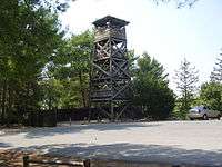
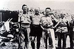
Kibbutz Hanita was established on 21 March 1938, as part of the Tower and stockade operation during the 1936–39 Arab revolt. However, Hanita was a special project, the largest of the entire operation and led directly by Yitzhak Sadeh, a top military leader of the Yishuv (Jewish community in Mandatory Palestine). Unlike other Tower and stockade settlements, Hanita was not established out of another nearby settlement, where all building material would be stored in advance, as was the rule. The lack of Jewish settlements in Western Galilee and the site's extremely remote location precluded that option. Four-hundred people contributed in the erection of the first walled camp, many notrim (Jewish Mandatory police) included. There were no roads leading to the site and materials had to be carried by hand under armed protection. Due to the 1937 Peel Commission report, the Yishuv leadership under David Ben-Gurion thought the partition of Palestine to be imminent, with the borders to be decided through diplomacy, and with no Jewish foothold the Western Galilee would remain out of bounds. Hanita was one of the new Jewish settlements established in the area, with an additional defensive role, as it sat directly on the border with Lebanon, which was at the time controlled by France. The establishment of Hanita was hailed as the most impressive action of the Tower and stockade operation, it was in part captured on film, and became the subject of an opera.[2][3][4]
Kibbutz Hanita was established on the site of an ancient ruin by that same name (Hanita; variant: Hanuta), and is mentioned in rabbinic writings: Tosefta (Shevi'it 4:9), the Jerusalem Talmud (Demai 2:1) and in the 3rd century Mosaic of Rehob. In the 1878 Palestine Exploration Fund Map published by C. R. Conder and HH Kitchener it was listed as the ruin, Khurbet Hanuta.
Economy
The economy is based on a combination of agriculture and industry. The kibbutz grows bananas, citrus fruits and field crops. Its main source of income comes from two factories: Kotlab produces metalized films for packaging, heat and cold insulation, and use in safety devices. Hanita Lenses produces contact lenses and lenses for implants.[5]
Museum
The kibbutz operates a museum documenting two topics: one is the history of the Tower and Stockade settlements built in response to the Arab riots of 1936-1939; the other topic is the archaeology of the area. The museum displays documents relating to the purchase of the land and the security problems faced by the kibbutz, as well as archaeological finds unearthed at Hanita and vicinity, including artistically impressive panels of a mosaic floor from the 6th-7th century Byzantine church, excavated next to the museum building.[6]
Notable residents
- Matti Caspi (born 1949), composer, musician, singer, and lyricist
- Eliezer Ben-Rafael, professor of sociology
Moshe Dayan
References
- ↑ "List of localities, in Alphabetical order" (PDF). Israel Central Bureau of Statistics. Retrieved 16 October 2016.
- ↑ Uniform (and History) of Jewish Palestine Police "Noter" Historama
- ↑ Foundations Of Excellence: Moshe Dayan And Israel's Military Tradition (1880 To 1950) Global Security
- ↑ The Establishment of the Jewish Agency and Expansion of the Yishuv Jewish Agency
- ↑ Hanita website
- ↑ Tower and stockade museum
| Wikimedia Commons has media related to Hanita. |