Holm Land
 Holm Land | |
| Geography | |
|---|---|
| Location | East Greenland |
| Coordinates | 80°20′N 18°10′W / 80.333°N 18.167°WCoordinates: 80°20′N 18°10′W / 80.333°N 18.167°W |
| Adjacent bodies of water | |
| Length | 88 km (54.7 mi) |
| Width | 42 km (26.1 mi) |
| Highest elevation | 1,627 m (5,338 ft) |
| Administration | |
|
Greenland (Denmark) | |
| Zone | NE Greenland National Park |
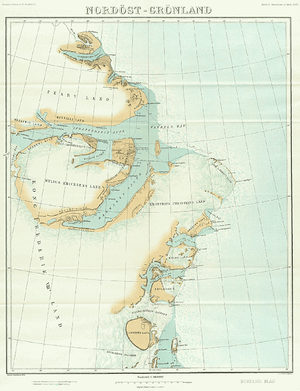
Holm Land (Danish: Holms Land), sometimes referred to as "Hahn Land",[1] is a peninsula in King Frederick VIII Land, northeastern Greenland.[2] Administratively it belongs to the NE Greenland National Park area.
This peninsula was named by the 1906-1908 Denmark expedition after Danish naval officer and Arctic explorer Gustav Frederik Holm.[3]
Geography
Holm Land is bounded in the north by the Ingolf Fjord, in the east by the Greenland Sea and in the south by the Hekla Sound and the Dijmphna Sound. Steep cliffs make up most of the southern shore.[4] To the south lie Lynn Island and larger Hovgaard Island. Eskimonæsset is the peninsula's easternmost point and Hanseraq Fjord is a small fjord in the eastern coast.[2]
Holm Land is mountainous, especially in its western part where the Princess Caroline Mathilde Alps (Prinsesse Caroline Mathilde Alper) run from north to south across the western end of the peninsula. The highest point reaches 1,627 m (5,338 ft) at 80°28′28″N 19°36′38″W / 80.47444°N 19.61056°W. Mallemukfjeldet is a high plateau in the eastern part.[5]
 Map of Northeastern Greenland. |
 1911 German map of NE Greenland showing Holm Land. |
References
- ↑ Peakbagger - Hahn Land High Point, Greenland
- 1 2 "Holm Land". Mapcarta. Retrieved 16 June 2016.
- ↑ "Catalogue of place names in northern East Greenland" (PDF). Geological Survey of Denmark. Retrieved 17 June 2016.
- ↑ Prostar Sailing Directions 2005 Greenland and Iceland Enroute, p. 128
- ↑ GoogleEarth