Hurricane Karen (2007)
| Category 1 hurricane (SSHWS/NWS) | |
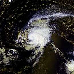
 Hurricane Karen near peak intensity | |
| Formed | September 25, 2007 |
|---|---|
| Dissipated | September 29, 2007 |
| Highest winds |
1-minute sustained: 75 mph (120 km/h) |
| Lowest pressure | 988 mbar (hPa); 29.18 inHg |
| Fatalities | None |
| Damage | None |
| Areas affected | No land areas |
| Part of the 2007 Atlantic hurricane season | |
Hurricane Karen was the eleventh named storm and fourth hurricane of the 2007 Atlantic hurricane season.[1] Karen was a Cape Verde-type hurricane that developed in the eastern tropical Atlantic out of a large tropical wave. The storm briefly reached Category 1 hurricane intensity before slowly weakening due to increased wind shear. As the storm remained away from land, no damages or fatalities were reported in association with Karen.
Meteorological history

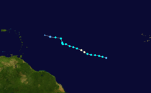
The system began as a tropical wave that emerged off the west coast of Africa on September 21. The wave was not well-organized with only scattered thunderstorm activity and large area of low pressure. As the system tracked westward south of Cape Verde, deep convection gradually increased, curved banding features became defined, and a poorly defined circulation became evident. Early on September 23, Dvorak classification estimates were introduced. Little change in organization took place until the evening of September 24. That evening, the low-level circulation and banding features became better defined as the system tracked west-northwest. Late that evening, the system was declared Tropical Depression Twelve while west-southwest of the Cape Verde islands.[2]
The tropical depression quickly intensified into early on September 25 as the system continued to organize, and was upgraded to Tropical Storm Karen that morning.[3] The strengthening trend was temporarily halted, and Karen remained a weak tropical storm with relatively shallow convection. Late that evening, new bursts of deep convection developed with the storm.[4] Early on September 26, Karen intensified significantly and an inner core began to develop.[5] That morning, a ragged eye developed and the system strengthened into a hurricane with 75 mph (120 km/h) winds.[2] The intensification trend was short-lived, and the storm leveled off that afternoon as upper-level wind shear increased substantially due to the presence of a nearby tropical upper tropospheric trough.[6] The storm became less organized that evening. Hurricane Karen weakened to a tropical storm as flight data from NOAA Hurricane Hunters confirmed surface winds of 72 mph (115 km/h) and a very large wind field late that evening.[7] Operationally, Karen was classified as a strong tropical storm, but was reclassified as a Category 1 hurricane based on data from the reconnaissance flight late on September 26 and the less organized structure of the storm at that time.[2]

A slow weakening trend began early on September 27 due to the increased shear while remaining on a west-northwest track.[8] At the same time, the center of circulation became exposed at times due to the southwesterly wind shear. As a result, an unusual wind field was observed in that the strongest winds were recorded well to the east and to the northwest of the center.[9] The weakening trend remained fairly slow that evening as the storm continued to produce persistent deep convection.[10] The weakening trend accelerated on September 28 as the convection weakened and the circulation became more disorganized in the high-shear environment.[11] By that morning, Karen weakened to a minimal tropical storm with 40 mph (65 km/h) winds.[12] Karen also turned abruptly to the north for a short while, as convection interacted with the low-level center and southerly winds increased in the low-level environment.[2] The weakening trend slowed that afternoon as deep convection returned to the disorganized storm.[13] Early on September 29, the high wind shear continued and Karen weakened to a tropical depression with a very poorly defined center.[2][14] That afternoon, the circulation dissipated while east of the Lesser Antilles. Remnant squalls continued across the area east of the Lesser Antilles for a few days after dissipation.[2]
Impact
The National Hurricane Center briefly assessed a minimal threat to the Lesser Antilles, with one forecaster noting a 5% probability for the cyclone to produce tropical storm winds on Barbuda.[15] However, Karen stayed in the open Atlantic Ocean and never affected any land area. No incidents of damage or casualties were reported.[2] No ship reports of tropical storm-force or stronger were received.[2] Some of the vorticity from Karen's remnants may have been responsible for the development of the short-lived Tropical Depression Fifteen on October 11.[16]
See also
- 2007 Atlantic hurricane season
- Timeline of the 2007 Atlantic hurricane season
- List of storms in the 2007 Atlantic hurricane season
- Other storms of the same name
References
- ↑ "Tropical Storm Karen nears hurricane strength". Reuters. 2007-09-26. Retrieved 2007-12-30.
- 1 2 3 4 5 6 7 8 National Hurricane Center (2007). "Tropical Cyclone Report for Hurricane Karen" (PDF). Retrieved 2007-11-28.
- ↑ Beven (2007-09-25). "Tropical Storm Karen Discussion #2". National Hurricane Center. Retrieved 2007-11-28.
- ↑ Brown (2007-09-25). "Tropical Storm Karen Discussion #5". National Hurricane Center. Retrieved 2007-11-28.
- ↑ Brown (2007-09-26). "Tropical Storm Karen Discussion #6". National Hurricane Center. Retrieved 2007-11-28.
- ↑ Landsea/Pasch (2007-09-26). "Tropical Storm Karen Discussion #8". National Hurricane Center. Retrieved 2007-11-28.
- ↑ Blake (2007-09-26). "Tropical Storm Karen Discussion #9". National Hurricane Center. Retrieved 2007-11-28.
- ↑ Mainelli (2007-09-27). "Tropical Storm Karen Discussion #10". National Hurricane Center. Retrieved 2007-11-28.
- ↑ Roberts/Avila (2007-09-27). "Tropical Storm Karen Discussion #11". National Hurricane Center. Retrieved 2007-11-28.
- ↑ Blake (2007-09-27). "Tropical Storm Karen Discussion #13". National Hurricane Center. Retrieved 2007-11-28.
- ↑ Mainelli (2007-09-28). "Tropical Storm Karen Discussion #14". National Hurricane Center. Retrieved 2007-11-28.
- ↑ Roberts (2007-09-28). "Tropical Storm Karen Discussion #15". National Hurricane Center. Retrieved 2007-11-28.
- ↑ Roberts (2007-09-28). "Tropical Storm Karen Discussion #16". National Hurricane Center. Retrieved 2007-11-28.
- ↑ Avila (2007-09-29). "Tropical Depression Karen Discussion #19". National Hurricane Center. Retrieved 2007-11-28.
- ↑ Mainelli (2007). "Tropical Storm Karen Wind Speed Probabilities Number 14". National Hurricane Center. Retrieved 2007-11-28.
- ↑ Franklin (2007-10-11). "Tropical Depression Fifteen Discussion #1". National Hurricane Center. Retrieved 2007-11-28.
External links
| Wikimedia Commons has media related to Hurricane Karen (2007). |
- The NHC's archive on Hurricane Karen
