Illorsuit Island
|
Location of Illorsuit Island | |
| Geography | |
|---|---|
| Location | Uummannaq Fjord |
| Coordinates | 71°10′N 53°43′W / 71.167°N 53.717°WCoordinates: 71°10′N 53°43′W / 71.167°N 53.717°W |
| Area | 468 km2 (181 sq mi) |
| Administration | |
|
Greenland | |
| Municipality | Qaasuitsup |
Illorsuit Island (Greenlandic: Illorsuip qeqertaat, Danish: Ubekendt Ejland) is an island in the Qaasuitsup municipality in northwestern Greenland.
Geography

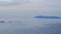
The southern part of Illorsuit Island seen across the northeastern part of Uummannaq Fjord, from the western ridge of the Nunaarssuaq mountain on the Ukkusissat Peninsula.
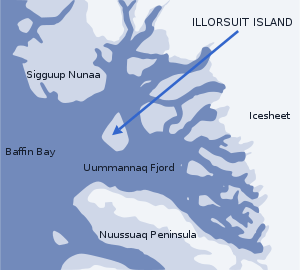
The island is pear-shaped, and at 468 km2 (180.7 sq mi),[1] it is the second-largest island in the Uummannaq Fjord system, located to the east of its mouth, between Sigguup Nunaa peninsula in the north and Nuussuaq Peninsula in the south.[2]
Settlement
Illorsuit is the only settlement on the island, located on the northeastern coast of the island.
References
- ↑ Norwegian University of Science and Technology
- ↑ Nuussuaq, Saga Map, Tage Schjøtt, 1992
This article is issued from Wikipedia - version of the 3/17/2013. The text is available under the Creative Commons Attribution/Share Alike but additional terms may apply for the media files.
