Indiana State Road 159
| ||||
|---|---|---|---|---|
 | ||||
| Route information | ||||
| Maintained by INDOT | ||||
| Length: | 32.61 mi (52.48 km) | |||
| Southern segment | ||||
| Length: | 6.07 mi (9.77 km) | |||
| South end: |
| |||
| North end: |
| |||
| Central segment | ||||
| Length: | 8.07 mi (12.99 km) | |||
| South end: | Greene-Sullivan State Forest | |||
| North end: |
| |||
| Northern section | ||||
| Length: | 18.47 mi (29.72 km) | |||
| South end: |
| |||
| North end: |
| |||
| Location | ||||
| Counties: | Clay, Knox, Sullivan, Vigo | |||
| Highway system | ||||
| ||||
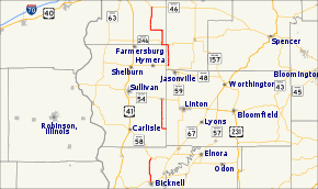
State Road 159 in the U. S. state of Indiana exists in three separate sections.
Route description
Southern section
The southern section begins at State Road 67 at Bicknell and ends at State Road 58 in Freelandville, 6 miles (9.7 km) to the north.
Middle section
The middle section begins at Pleasantville and ends at State Road 54 at Dugger, 8 miles (13 km) to the north.
Northern section
The northern section begins at State Road 48 at Shakamak State Park and ends at State Road 46 at Riley, 18.5 miles (29.8 km) to the north.
Major intersections
| County | Location | mi[1] | km | Destinations | Notes | ||
|---|---|---|---|---|---|---|---|
| Knox | Bicknell | 0.00 | 0.00 | Southern terminus of SR 159 | |||
| Freelandville | 6.07 | 9.77 | Northern terminus of the section of SR 159 | ||||
| Gap in route | |||||||
| Sullivan | Pleasantville | 6.07 | 9.77 | Southern terminus of the center section of SR 159 at the Green County line | |||
| Dugger | 14.14 | 22.76 | Northern terminus of the center section of SR 159 | ||||
| Gap in route | |||||||
| Clay | Coalmont | 14.14 | 22.76 | Shakamak State Park | |||
| Vigo | Pierson Township | 19.73 | 31.75 | Eastern end of SR 246 concurrency | |||
| 20.91 | 33.65 | Western end of SR 246 concurrency | |||||
| Riley | 32.61 | 52.48 | Northern terminus of SR 159 | ||||
1.000 mi = 1.609 km; 1.000 km = 0.621 mi
| |||||||
References
- ↑ "INDOT Roadway Referencing System" (PDF). staff.
External links
This article is issued from Wikipedia - version of the 6/11/2016. The text is available under the Creative Commons Attribution/Share Alike but additional terms may apply for the media files.
