Jalilabad District (Azerbaijan)
| Jalilabad | |
|---|---|
| Rayon | |
.svg.png) Map of Azerbaijan showing Jalilabad Rayon | |
| Country | Azerbaijan |
| Capital | Cəlilabad |
| Area[1][2] | |
| • Total | 1,440 km2 (560 sq mi) |
| Population (2011)[3] | |
| • Total | 196,500 |
| Postal code | AZ1500 |
| Telephone code | (+994) 25[4] |
Jalilabad (Cəlilabad) is a rayon of Azerbaijan. The capital is the city of Cəlilabad (also spelled Jalilabad).
Geography
The rayon borders upon Bilasuvar Rayon in the north, Neftchala Rayon in the east, Masally Rayon in the south, Yardymli Rayon in the south-west and Iran in the south.
Its territory consists of plains and low mountains. The altitude of some mountains in the east is below sea level. Climate is mild with dry summer. Average temperature is equal to 1-3°C in winter and 25-30°C in summer. Amount of annual precipitation is 400-600 mm. The Bolgarchay, Misharchay, Injachay, Goytapachay and other rivers flow through the rayon. Soils here are alluvial-meadow, chestnut, mountainous brown, forest soils and others. Forests occupy 17,7 thousand ha, and there is also a winter quarters for birds. Animals such as rabbit, wild boar, badger, wolf, fox, jackal, beaver and others, birds such as eagle, crow, lark, duck, coot, pheasant, stork, bustard and others inhabit the district.[5]
History
The rayon was originated on August 8, 1930. Until July 2, 1964 it was called Astrakhanbazar.[6]
Gallery
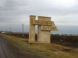
- Jalilabad Rayon
 Road sign at the entrance of Jalilabad Rayon
References
- ↑ "Cəlilabad Rayonu".
- ↑ "Cəlilabad Rayonu".
- ↑ "Cəlilabad Rayonu". The State Statistical Committee of the Republic of Azerbaijan.
- ↑ "Şəhərlərarası telefon kodları". Aztelekom MMC. Aztelekom İB. Retrieved 19 August 2015. (Azerbaijani)
- ↑ "Джалилабадский район". azerbaijan.az.
- ↑ "Jalilabad". discoverazerbaijan.az.
| Part of the series on |
| Azerbaijan Azərbaycan |
|---|
  |
| Culture |
| History |
| Demographics |
| Geography |
| Administrative divisions |
| Azerbaijan portal |
Coordinates: 39°12′N 48°18′E / 39.200°N 48.300°E