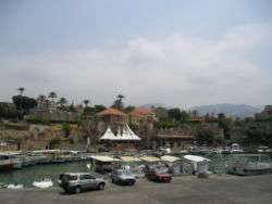
Jbeil District
| Jbeil District | |
|---|---|
| District | |
| قضاء جبيل | |
|
Byblos Harbor | |
| Country |
|
| Governorate | Mount Lebanon |
| Capital | Byblos (Jbeil) |
| Area | |
| • Total | 170 sq mi (430 km2) |
| Population | |
| • Total | 82,500 |
| Time zone | EET (UTC+2) |
| • Summer (DST) | EEST (UTC+3) |
Jbeil District (Arabic: قضاء جبيل; transliteration: Qadaa' Jbail) is a district (qadaa) of the Mount Lebanon Governorate of Lebanon. It is located to the northeast of Lebanon's capital Beirut. The capital is Byblos, also known as Jbeil. The rivers of al-Madfoun and Nahr Ibrahim form the district's natural northern and southern borders respectively, with the Mediterranean Sea bordering it from the west and Mount Lebanon from the east, separating it from the adjacent district of Baalbek in the Beqaa Valley.
Demographics
The district's population is predominantly Maronite Catholic, followed by a Shia Muslim minority community.[1] The largest towns of the district are predominantly inhabited by Maronites; they are Byblos (Jbeil), Qartaba, Aqoura and Amsheet.[1] Most Shia Muslims live in the valley of the Ibrahim River, particularly in the villages of Almat, Ras Osta, Hjoula, Bichtlida, Lassa, and Mazraat es-Siyad. A Greek Orthodox minority forms part of the population and is spread among several villages know locally as qornet el-roum (the corner of the Greek Orthodox). The villages that make up qournet el-roum are Mounsef, Jeddayel, Helwe, Berbara, Gharzouz, Rihanneh and Chikhane.
Jbeil District has three seats allocated to it in the Lebanese Parliament. Two of these seats are allocated to Maronite Catholics, while the other seat is allocated to Shia Muslims. As of 2009, the religious make-up of the Jbeil District's 75,584 voters were roughly 70% Maronite Catholic, 19% Shia Muslim and 5% Greek Orthodox.[1]
Landmarks and sights
The Jbeil District hosts a number of significant sites. The capital Byblos is an important historical and archaeological site boasting Phoenician, Roman, and Crusader ruins. The mountain village of Aannaya hosts the Saint Maroun-Aannaya monastery and the Catholic shrine of Saint Charbel (1828-1898), the first Lebanese saint (officially canonized by Pope Paul VI in 1977), both significant religious Maronite Christian holy sites. The village of Laqlouq, which has an altitude of 1,750 meters to 2,000 meters, is a ski resort. The village of Afqa contains the Afqa grotto, which is the source of the Nahr Ibrahim, also known as the Adonis River. The village of Bentael (also spelled Bintaael) contains the first protected area in Lebanon, established in 1981. The village of Jaj hosts surviving cedar trees from the ancient cedar forests from which cedar wood was exported to Egypt and later to Jerusalem.
Towns and villages
- Aabaydat
- Almat el-Chmaliyeh
- Almat el-Jnoubiyeh
- Amsheet
- Annaya
- Aqoura
- Adonis
- Afqa
- Ain ed-Delbeh
- Ain el-Ghouaybeh
- Ain Jrain
- Ain Kfaa
- Bazyoun
- Bchilleh
- Beer el-Hit
- Behdidat
- Bejjeh
- Bekhaaz
- Berbara
- Beithabbak
- Bichtlida
- Bentael
- Birket Hjoula
- Blat
- Boulhos
- Brayj
- Chatine
- Chikhane
- Chmout
- Edde
- Ehmej
- Fatreh
- Ferhet
- Fghal
- Fidar
- Ghabat
- Ghalboun
- Gharzouz
- Ghorfine
- Habil
- Halat
- Haqel
- Hay el-Arabeh
- Hbaline
- Hboub
- Hdayneh
- Hjoula
- Hosrayel
- Hsarat
- Hsoun
- Jaj
- Janneh
- Jbeil
- Jeddayel
- Jenjol
- Jlisseh
- Jouret El Qattine
- Kafr
- Kfar Baal
- Kfar Hitta
- Kfar Kiddeh
- Kfar Masshoun
- Kfar Qouas
- Kfoun
- Laqlouq
- Lassa
- Lehfed
- Maad
- Majdel
- Marj
- Mastita
- Mayfouq
- Mazraat es-Siyad
- Mechane
- Mghayreh
- Mish Mish
- Mounsef
- Nahr Ibrahim
- Qahmez
- Qartaba
- Qartaboun
- Qorqraiya
- Ram
- Ras Osta
- Rihaneh
- Seraaita
- Souaneh
- Tartej
- Tourzaiya
- Yanouh
- Zibdine
References
- 1 2 3 "Districts in Depth: Jbeil". NOW News. 2009-05-28. Retrieved 2016-02-12.
Coordinates: 34°07′25″N 35°39′04″E / 34.12361°N 35.65111°E

