Cape Lollo
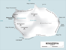
Map of Bouvetøya
Cape Lollo (Norwegian: Kapp Lollo), located at 54°25′S 3°29′E / 54.417°S 3.483°ECoordinates: 54°25′S 3°29′E / 54.417°S 3.483°E, is a cape which forms the northeastern extremity of Bouvetøya. It was first charted in 1898 by a German expedition under Carl Chun, and was recharted and named in December 1927 by a Norwegian expedition under Captain Harald Horntvedt.[1][2]
References
- ↑ "Cape Lollo". Geographic Names Information System. United States Geological Survey. Retrieved 2013-06-28.
- ↑ "Prof. Dr. phil., Dr. med. h. c. Carl Chun". University of Leipzig. Retrieved October 1, 2016.
![]() This article incorporates public domain material from the United States Geological Survey document "Cape Lollo" (content from the Geographic Names Information System).
This article incorporates public domain material from the United States Geological Survey document "Cape Lollo" (content from the Geographic Names Information System).
This article is issued from Wikipedia - version of the 11/1/2016. The text is available under the Creative Commons Attribution/Share Alike but additional terms may apply for the media files.