Katō, Hyōgo
| Katō 加東市 | ||
|---|---|---|
| City | ||
| ||
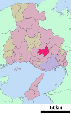
 Location of Katō in Hyōgo Prefecture | ||
 Katō Location in Japan | ||
| Coordinates: 34°55′N 134°58′E / 34.917°N 134.967°ECoordinates: 34°55′N 134°58′E / 34.917°N 134.967°E | ||
| Country | Japan | |
| Region | Kansai | |
| Prefecture | Hyōgo Prefecture | |
| Government | ||
| • Mayor | Masayoshi Yasuda (since April 2010) | |
| Area | ||
| • Total | 157.49 km2 (60.81 sq mi) | |
| Population (February 1, 2012) | ||
| • Total | 40,194 | |
| • Density | 260/km2 (660/sq mi) | |
| Symbols | ||
| • Tree | Cherry blossom | |
| • Flower | Cosmos | |
| Time zone | Japan Standard Time (UTC+9) | |
| City hall address |
50 Yashiro, Kato-shi, Hyogo-ken 673-1493 | |
| Website |
www | |
Katō (加東市 Katō-shi) is a city in Hyōgo Prefecture, Japan.
The modern city of Katō was established on March 20, 2006 from the merger of the former towns of Takino, Tōjō and Yashiro (all from Katō District).
As of February 1, 2012, the city has an estimated population of 40,194, with 14,865 households and a population density of 255.22 persons per km². The total area is 157.49 square kilometres (60.81 sq mi).
International relations
Twin towns – Sister cities
Katō is twinned with:
-
 Olympia, Washington, United States
References
External links
| Wikimedia Commons has media related to Katō, Hyōgo. |
- Katō City official website (Japanese)
This article is issued from Wikipedia - version of the 8/26/2016. The text is available under the Creative Commons Attribution/Share Alike but additional terms may apply for the media files.