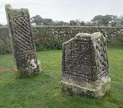
King Doniert's Stone

King Doniert's Stone (Cornish: Menkov Donyerth Ruw)[1] consists of two pieces of a decorated 9th century cross, located near St Cleer, Bodmin Moor, Cornwall. The inscription is believed to commemorate Dungarth, King of Cornwall who died around 875.
History
In the fifth century, Christianity was first brought to Cornwall by monks from Wales and Ireland. The early missionaries are believed to have erected wooden crosses to show places in which they had won victories for Christ. In time these places became sanctified and the wooden crosses were replaced by stone ones.[2]
The site
The site consists of the remains of two 9th-11th century granite cross-shaft fragments and an underground passage and cross shaped chamber below the crosses thought to be either the remains of tin workings or a possible oratory.[3] The northern cross, termed the "Doniert Stone" is 1.37 metres high with panels of interlace decoration on three sides and inscription "doniert rogavit pro anima" carved in Insular script .[3] The inscription translates as "Doniert has asked [for this to be made] for his soul[’s sake’]".[4] The inscription is thought to refer to the local ruler "Dumgarth" (or "Dwingarth") who is recorded in the early Welsh chronicle known as the Annales Cambriae, as having drowned in around 875 AD.[3][4] It has a mortise slot and a plinth at the base.[3]
The southern cross, sometimes referred to as the "Other Half Stone", is 2.1 metres high with a panel of interlace decoration on the east face, a broken mortise slot at the top and a plinth at the bottom.[3]
The underground rock-cut chamber begins as a passage about 8 metres to the south east of the crosses, turns into a tunnel and ends as a cruciform chamber beneath the crosses.[3] The relationship between the underground chamber and the crosses is unknown.[4]
The site is managed by the Cornwall Heritage Trust on behalf of English Heritage.[5] Vehicles can park in a layby adjoining the site, entry is free and the site can be visited at any reasonable time during daylight hours.[2]
References
| Wikimedia Commons has media related to King Doniert's Stone. |
- ↑ Place-names in the Standard Written Form (SWF) : List of place-names agreed by the MAGA Signage Panel. Cornish Language Partnership.
- 1 2 "King Doniert's Stone". English Heritage. Retrieved 13 August 2016.
- 1 2 3 4 5 6 Scheduled Monument description quoted in Pastscape
- 1 2 3 History and research on King Doniert's Stone: English Heritage
- ↑ "Index, Sites Managed and Cared for by Cornwall Heritage Trust for English Heritage UK". cornwallheritagetrust.org. 2012. Retrieved 25 April 2012.
Coordinates: 50°29′34.1″N 4°29′17.2″W / 50.492806°N 4.488111°W
