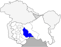
Kishtwar district
| Kishtwar district | |
|---|---|
| District | |
 Location in Jammu and Kashmir, India | |
| Coordinates: 33°18′46″N 75°46′10″E / 33.312683°N 75.769447°ECoordinates: 33°18′46″N 75°46′10″E / 33.312683°N 75.769447°E | |
| Country |
|
| State | Jammu and Kashmir |
| Headquarters | Kishtwar |
| Area | |
| • Total | 7,824 km2 (3,021 sq mi) |
| Population (2011)[1] | |
| • Total | 230,696 |
| • Density | 29/km2 (76/sq mi) |
| Languages | |
| • Official | Urdu |
| Time zone | IST (UTC+5:30) |
| Website | http://kishtwar.nic.in |
Kishtwar District is a beautiful district of the state of Jammu and Kashmir of India. As of 2011, it is the third least populous district of Jammu and Kashmir (out of 22), after Kargil and Leh. It has highest wattage production in the world for such a small area. It's Famous For World Renowned Sapphire & Saffron. It's Situated On The Banks Of River Chenab.
Administration
Kishtwar district consists of 9 blocks: Marwah, Warwan, Dachan, Kishtwar, Nagsani, Drabshalla, Inderwal, Chatroo, and Paddar.[2] Each block consists of a number of panchayats.
Block Kishtwar is the 1st block of Kishtwar District and Beron Town 1st Kishtwar is the 1st panchayat of Block Kishtwar, beron town panchayat consists of Panditgam, Zewar, Nagdera, Bucherwal Mohalla, Semmna and Wazgwari
Kishwar Sub-District:
Marwah Sub-District:
- Warwan tehsil
- Dachan tehsil
Padder Sub-District:
- Padder tehsil is the most remote town of the district bordered by Zanskar to the east and towered by the Sickle Moon Peak.
Politics
Kishtwar District has 2 assembly constituencies: Inderwal and Kishtwar.[3] Marwah consist 12 panchayats 1.Nowpachi2.Nowgam.3.yourdu.4 pethgam.5.Ranie A.6 Ranie B 7.Quderna.8 Quderna B.9 Chanjer.10 Dehrana.11 Hanzal.12.Teller. BJP and CONG won one Assembly Constituency each respectively.
Demographics
According to the 2011 census Kishtwar district has a population of 227,976, roughly equal to the nation of Vanuatu.[4] This gives it a ranking of 586th in India (out of a total of 640). The district has a population density of 29 inhabitants per square kilometre (75/sq mi) .[5] Its population growth rate over the decade 2001-2011 was 21.06%.[5] Kishtwar has a sex ratio of 938 females for every 1000 males, and a literacy rate of 58.54%. [Male 71.75% [Female 44.13%]. The district is Muslim majority 57.75%, with Hindus constituting 40.72% of the population.
Famous Personalities of Marwah Kishtwar
1-Mohmmad Ramzan 2-Poet Ambir Din 3-Poet Ahad Tak 4-Tawseef Ali Malik-Innovator 5-Sewa Ram Parihar(Ex-MLC) 6- Nishat Kishtwari (Poet) 7- Janbaaz (Poet & Singer) 8- Syed Mir Badshah (Social Activist) 9- Ishrat Kashmiri (Ex-MLA) 10- Bashir Ahmed Kichloo (Cabinet Minister)
References
- ↑ Census of India 2011
- ↑ Statement showing the number of blocks in respect of 22 Districts of Jammu and Kashmir State including newly Created Districts dated 2008-03-13, accessed 2008-08-30
- ↑ "ERO's and AERO's". Chief Electoral Officer, Jammu and Kashmir. Retrieved 2008-08-28.
- ↑ US Directorate of Intelligence. "Country Comparison:Population". Retrieved 2011-10-01.
Vanuatu 224,564 July 2011 est.
- 1 2 "District Census 2011". Census2011.co.in. 2011. Retrieved 2011-09-30.
Further reading
- Qazi, S.A. (2005), "Part II: Doda district", Systematic Geography of Jammu and Kashmir, APH Publishing, pp. 210–, ISBN 978-81-7648-786-3
External links
| Wikimedia Commons has media related to Kishtwar district. |
- kishtwar.nic.in
- Kishtwar.com
- Kishtwartimes.com
- List of places in Kishtwar
 |
Anantnag district | Kargil district |  | |
| |
||||
| ||||
| | ||||
| Doda district | Chamba district, Himachal Pradesh | Lahaul and Spiti district, Himachal Pradesh |