Knockan Crag


Knockan Crag is a line of cliffs on the Ross-Shire and Sutherland border area of Scotland 21 kilometres (13 mi) north of Ullapool. The name is an anglicisation of the Gaelic Creag a' Chnocain meaning 'crag of the small hill'.[1]
The Moine Thrust runs through the crag and there is a small visitor centre providing interpretation and artwork that explains the background to the 'Highlands Controversy' concerning the geology of the area.
Geological significance
During the 19th century prominent geologists conducted a prolonged and bitter debate about the fault line exposed here. The argument was primarily between Roderick Murchison and Archibald Geikie on the one hand and James Nicol and Charles Lapworth on the other. This was finally resolved by the work of Ben Peach and John Horne whose 1907 paper on the subject remains a classic text.[2][3]
The main issue was that the Moine schists at the top of the crag appeared to be older than the Cambrian and Ordovician rocks such as Durness limestone lower down. Murchison and Geikie believed the sequence was wrong and that the Moine schists must be the younger rocks. The conundrum was explained by the action of a thrust fault - this being the first to be discovered anywhere in the world. The older rocks had been moved some 70 kilometres to the west over the top of the younger rocks due to tectonic action.[4]
A monument to Peach and Horne's work was erected by the international geological community at Inchnadamph a few miles to the north.
Visitor Centre
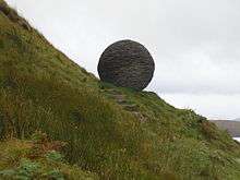
Scottish Natural Heritage manages the Knockan Crag National Nature Reserve and provides an interpretation centre, car park and various walks along the crag explaining the features and including artwork such as 'The Globe' by Joe Smith.
Knockan Crag is part of the North West Highlands Geopark, inaugurated in 2004 and part of the International Network of Geoparks.[5]
See also
References
- ↑ "Knockan Crag National Nature Reserve". Scottish Natural Heritage. Retrieved 2007-09-08.
- ↑ Peach, B.N., Horne, J., Gunn, W., Clough, C.T., Hinxman, L.W., and Cadell, H.M. (1888) Report on the recent work of the Geological Survey in the north-west Highlands of Scotland, based on field notes and maps by Messrs. B.N. Peach, J. Horne, W. Gunn, C.T. Clough, L.W. Hinxman, L.W. and H.M. Cadell. Quarterly Journal of the Geological Society of London, 44, 378-441.
- ↑ Peach, B.N., Horne, J., Gunn, W., Clough, C.T., and Hinxman, L.W., (1907) The Geological Structure of the Northwest Highlands of Scotland. Memoirs of the Geological Survey of Great Britain.
- ↑ Dryburgh, P. M. et al. (1995) Assynt: The geologists' Mecca. Edinburgh Geological Society.
- ↑ North West Highlands Geopark. North West Highlands Geopark. Retrieved 18 August 2007.
External links
- Knockan Crag National Nature Reserve - official site
Coordinates: 58°02′20″N 5°03′44″W / 58.03887°N 5.06212°W