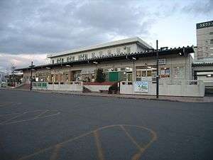
Kuji Station (Iwate)
Kuji 久慈 | |
|---|---|
 JR Kuji Station, February 2007 | |
| Location |
3-39-3 Chuo, Kuji, Iwate (岩手県中央三丁目39-3) Japan |
| Operated by | |
| Line(s) | |
| Connections |
|
| History | |
| Opened | 1930 |
| Traffic | |
| Passengers (FY 2012 (JR)) | 235 (JR)) daily |

Kuji Station (久慈駅 Kuji-eki) is a railway station on the Hachinohe Line in Kuji, Iwate, Japan, operated by East Japan Railway Company (JR East).
Lines
Kuji Station a terminal station on the Hachinohe Line, and is located 64.9 rail kilometers from the opposing terminus of the line at Hachinohe Station. It is also a terminal station for the Sanriku Railway North Rias Line and is 71.0 rail kilometers from the opposing terminus at Miyako Station.
Station layout
Kuji Station has a single island platform connected to the station building by an overhead crossing. The station has a Green Window ticket booth. The side of the platform used by the Sanriku Railway is also used by three starting trains per day on the Hachinohe Line.
Platforms
| 1 | ■ Hachinohe Line | for Taneichi and Hachinohe |
| 2 | ■ Sanriku Railway | for Fudai and Tanohata |
| ■ Hachinohe Line | for Taneichi and Hachinohe |
Adjacent stations
| « | Service | » | ||
|---|---|---|---|---|
| Hachinohe Line | ||||
| Rikuchū-Natsui | - | Terminus | ||
| Sanriku Railway | ||||
| Terminus | - | Rikuchū-Ube | ||
Route bus
- JR Bus Tohoku
- For Ninohe Station(Tōhoku Shinkansen Relay Bus "Swallow")
- For Morioka Station via Rikuchū-Yamagata, Kuzumai and Numakunai(Express Bus "Shirakaba")
- Northern Iwate Transportation
- For Morioka Station, Morioka Bus Center (Express Bus "Kuji Kohaku")
- For Tokyo Dome Hotel, Tokyo Station, Roppongi Hills, Tamachi Station(Express Bus "Iwate Kizuna", with Fuji Express)
History
Kuji Station opened on 27 March 1930. The station became a terminal station for the Kuji Line on 20 July 1976. This line was privatized on 1 April 1984, becoming the Sanriku Railway Kita-Rias Line. Kuji Station was absorbed into the JR East network upon the privatization of the Japanese National Railways (JNR) on 1 April 1987. The 2011 Tōhoku earthquake and tsunami on 11 March 2011 destroyed much of the tracks and many stations on both the Hachinohe Line and the Sanriku Railway. However, the Sanriku Railway resumed operations to Rikuchū-Noda Station by 16 March and to Tanohata Station by 1 April 2012. The Hachinohe Line resumed operations on 17 March 2012.
Surrounding area
- Kuji Post office
External links
| Wikimedia Commons has media related to Kuji Station (Iwate). |
- JR East Station information (Japanese)
- Sanriku Railway Station information (Japanese)
Coordinates: 40°11′26″N 141°46′15″E / 40.190519°N 141.770847°E