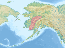
Kuskokwim Mountains
| Kuskokwim Mountains | |
|---|---|
 | |
| Highest point | |
| Peak | Dillingham High Point |
| Elevation | 5,250 ft (1,600 m) [1] |
| Coordinates | 63°00′00″N 156°30′00″W / 63.00000°N 156.50000°WCoordinates: 63°00′00″N 156°30′00″W / 63.00000°N 156.50000°W |
| Geography | |
| Country | United States |
| State | Alaska |
| Borders on | Pacific Coast Ranges |

Water-worn gold nugget from the Kuskokwim Mountains. Weight: 2.16 troy ounces / 67 grams.
The Kuskokwim Mountains is a range of mountains in the Yukon-Koyukuk Census Area, Alaska, United States,[2] west of the Alaska Range and southeast of the Yukon River. The Kuskokwim Mountains begin in the interior west of Fairbanks. The mountain range is about 400 km (250 mi) long from northeast to southwest and about 80 km (50 mi) wide.
The range takes its name from the Kuskokwim River, which flows through the mountains.[2]
Reported and defined in 1898 by Josiah Edward Spurr of the USGS. Spurr applied the name "Tanana Hills" to the low mountains at the northeast end of what are now the Kuskokwim Mountains.[2]
Sub-ranges
- Ahklun Mountains
- Eek Mountains[3]
- Wood River Mountains[4]
- Russian Mountains[5]
- Kilbuck Mountains[6]
References
| Wikimedia Commons has media related to Minerals of Kuskokwim Mts. |
- ↑ Dillingham High Point, peakbagger.com
- 1 2 3 "Kuskokwim Mountains". Geographic Names Information System. United States Geological Survey. March 31, 1981. Retrieved November 15, 2013.
- ↑ "Eek Mountains". Geographic Names Information System. United States Geological Survey. Retrieved January 11, 2016.
- ↑ "Wood River Mountains". Geographic Names Information System. United States Geological Survey. Retrieved January 11, 2016.
- ↑ "Russian Mountains". Geographic Names Information System. United States Geological Survey. Retrieved January 11, 2016.
- ↑ "Kilbuck Mountains". Geographic Names Information System. United States Geological Survey. Retrieved January 11, 2016.
This article is issued from Wikipedia - version of the 1/16/2016. The text is available under the Creative Commons Attribution/Share Alike but additional terms may apply for the media files.