Langwathby
| Langwathby | |
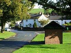
 Village green |
|
 Langwathby |
|
| Population | 866 (2011)[1] |
|---|---|
| OS grid reference | NY569336 |
| Civil parish | Langwathby |
| District | Eden |
| Shire county | Cumbria |
| Region | North West |
| Country | England |
| Sovereign state | United Kingdom |
| Post town | PENRITH |
| Postcode district | CA10 |
| Dialling code | 01768 |
| Police | Cumbria |
| Fire | Cumbria |
| Ambulance | North West |
| EU Parliament | North West England |
| UK Parliament | Penrith and the Border |
Coordinates: 54°41′45″N 2°40′12″W / 54.695938°N 2.670071°W
Langwathby is a village and civil parish in northern Cumbria, England, about 5 miles (8.0 km) north east of Penrith on the A686 road. The village lies on the banks of the River Eden.
The village is centred on a large village green next to which stands the village pub, post office and village hall. There is a primary school on the road to Little Salkeld.
At Langwathby Hall was the visitor attraction and working ostrich farm called Eden Ostrich World, which closed in 2012.
The Settle to Carlisle Railway has a railway station in the village.
The parish includes the nearby village of Edenhall which was a separate parish until 1934.
Langwathby is also the base of the 'Pride of Cumbria', one of the helicopters run by the Great North Air Ambulance Service
Etymology
'Langwathby' can be translated as 'long' ('lang'), 'ford' ('wath', Old Norse 'vað'), 'village' (Old English 'bȳ', Old Norse 'býr'), referring to the fording of the River Eden which runs along the edge of the village. [2]
Governance
An electoral ward in the same name exists. This ward stretches north east to Gamblesby and south to Edenhall with a total population taken at the 2011 Census of 1,562.[3]
Industry
At Langwathby there is a chicken processing factory and an animal feed mill.
At Barbary Plains just outside Edenhall there was formerly a cement block works formerly owned by Hanson plc and later by RMC Group, part of Cemex. The site is now a depot and head office for a haulage company.
See also
References
- ↑ "Parish population 2011". Retrieved 22 June 2015.
- ↑ Armstrong, A. M.; Mawer, A.; Stenton, F. M.; Dickens, B. (1950). The place-names of Cumberland. English Place-Name Society, vol.xxi. Part 1. Cambridge: Cambridge University Press. pp. 218–219.
- ↑ "Ward population 2011". Retrieved 22 June 2015.
External links
 Media related to Langwathby at Wikimedia Commons
 - Cumbria County History Trust: Langwathby (nb: provisional research only - see Talk page)