Larsmo
| Larsmo | ||
|---|---|---|
| Municipality | ||
| Larsmo kommun Luodon kunta | ||
|
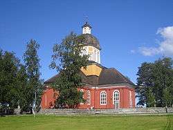
Larsmo Church | ||
| ||
 Location of Larsmo in Finland | ||
| Coordinates: 63°45′N 022°45′E / 63.750°N 22.750°ECoordinates: 63°45′N 022°45′E / 63.750°N 22.750°E | ||
| Country | Finland | |
| Region | Ostrobothnia | |
| Sub-region | Jakobstad sub-region | |
| Charter | 1867 | |
| Government | ||
| • Municipal manager | Gun Kapténs | |
| Area (2011-01-01)[1] | ||
| • Total | 853.51 km2 (329.54 sq mi) | |
| • Land | 142.44 km2 (55.00 sq mi) | |
| • Water | 711.07 km2 (274.55 sq mi) | |
| Area rank | 133rd largest in Finland | |
| Population (2016-03-31)[2] | ||
| • Total | 5,132 | |
| • Rank | 198th largest in Finland | |
| • Density | 36.03/km2 (93.3/sq mi) | |
| Population by native language[3] | ||
| • Swedish | 92.5% (official) | |
| • Finnish | 6.5% (official) | |
| • Others | 1% | |
| Population by age[4] | ||
| • 0 to 14 | 29.3% | |
| • 15 to 64 | 58.8% | |
| • 65 or older | 11.9% | |
| Time zone | EET (UTC+2) | |
| • Summer (DST) | EEST (UTC+3) | |
| Municipal tax rate[5] | 18.5% | |
Larsmo (Finnish: Luoto) is a municipality of Finland, located in the Ostrobothnia region of the province of Western Finland.
"Larsmo" is also the name of one of the villages in the municipality of Larsmo. The municipality is bilingual with Swedish as the majority language and Finnish as the minority language.[6] Until 2014 Swedish was Larsmo's only official language. The municipality and consists of an archipelago of about 360 islands and numerous skerries. The length of the coastline is about 500 kilometres (310 mi). Lake Larsmo (Larsmosjön), which is Finland's largest artificial fresh water lake is also located in the municipality.
The municipality has a population of 5,132 (31 March 2016)[2] and covers an area of 853.51 square kilometres (329.54 sq mi) of which 711.07 km2 (274.55 sq mi) is water. The population density is 36.03 inhabitants per square kilometre (93.3/sq mi).
History
The land, which was to become Larsmo rose from the sea some 2,000 years ago, due to post-glacial rebound. Today the municipality consists of more than 360 islands.
The administrative municipality Larsmo was founded in 1867, having previously belonged to the parish of Pedersöre. Hunting, fishing and agriculture used to be important sources of income. However, industry and service have now taken over since the changes of agriculture nowadays require larger farms to be profitable. The businesses are mainly influenced by the strong traditions of crafting or boat building.
The municipality came to play an interesting role in the Finnish independence-movement. During the dark autumn night of December 6, 1905, the steamer S/S John Grafton sailed into the Larsmo archipelago with its cargo of weapons, meant to be used for the independence movement in Finland and the revolutionary attempts in Russia. The cargo was unloaded and transported away with the help of the local population. However, the ship ran aground when the ship was heading out to sea. The crew decided to blow up the ship before the Russian guards would find it. The crew fled to Sweden with some smaller sailing vessels and the ship was blown up on December 8. News about the mystical ship spread around the world, and were mentioned in i.e. The Times, Deutsche Tageblatt and the Daily Mail. This incident is often counted as the first attempt for a free Finland and to obtain independence from Russia. S/S Equity, another ship, loaded with weapons, also unloaded its cargo in the Larsmo archipelago, and a memorial plate is now in place at the Tolvmangrundet island.
Coat-of-arms
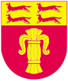
The municipal coat-of-arms was officially approved in 1952. It has been designed by Gustav von Numers and depicts a two-masted skötbåt in silver on a blue shield (a skötbåt is a traditional fishing vessel which could be sailed or rowed). The coat-of-arms symolizes the boatbuilding and fishing traditions in the municipality.
Settlements
The two largest islands are called Larsmo and Eugmo, and these two islands also make up the two administrative villages of the municipality. Larger settlements are Risö häll, Holm, Eugmo and Bosund. The church village is called Fagernäs and is located on the Larsmo island.
Politics
Results of the Finnish parliamentary election, 2011 in Larsmo:
- Christian Democrats 42.7%
- Swedish People's Party 37.3%
- Social Democratic Party 13.8%
- True Finns 2.8%
- National Coalition Party 0.9%
- Centre Party 0.8%
- Left Alliance 0.8%
- Green League 0.4%
Business
The municipality has always been connected to ship building and still is. Among the more famous ones are Baltic Yachts, the world's leading constructor of high-tech sailing yachts in carbon fiber, as well as Bella boats.
Culture
A number of cultural events are held every summer in the municipality. A small jazz festival, called Föusjazz ("barn jazz") is arranged every summer at the stone barn in Fagernäs. Many famous jazz artists have appeared at the festival. Many events are also held at Köpmanholmen and at Bjärgas hembygdsgård. A fish market is held every summer at the fishing harbour in Bosund.
There are two museums in the municipality. The previously mentioned Bjärgas hembygdsgård is displaying how the rural society was in the 1930s and also how a countryside shop looked like in the 1950s. The Bosund boat and fishing museum (Bosund båt- och fiskemuseum) displays older boats and fishing and hunting equipment. The exhibit Terra Mare at Köpmanholmen shows how post-glacial rebound has affected the coastal landscape.
The two libraries in Holm and in Bosund are serving the inhabitants of the municipality. Further there are two more school libraries, one in Risö and one in Näs.
Communications
- Roads
Larsmo is located between two cities Jakobstad in the south, and Kokkola in the north. The lively trafficked "Seven Bridge's Road" (De sju broarnas väg) is going through Larsmo and is connecting the municipality with the main land. The road's official designation is Regional Road 749.
- Buses
The Haldin & Rose bus company has a number of lines going through the municipality.
- Railroad
There is no railroad in the municipality. The closest stops are located in Bennäs or Kokkola.
- Airports
The closest airports are Kokkola-Pietarsaari Airport, which is about 30 km (20 mi) from Holm, and the Vaasa Airport, which lies about 120 km (75 mi) away. There is also a small field for ultra-light aircraft in Bosund.
- Ferries
The closest ferry route to Sweden is RG Line from Vaasa in Finland to Umeå in Sweden. Jakob Lines, which went from Jakobstad and Kokkola ceased their activities in 1999.
Recreation
There are a lot of paved pedestrian roads in the municipality. There are walking paths of different lengths in Holm (8 and 13 km), as well as in Fagernäs (5 km), Bosund (8 km) and on Öuran (5.7 km).
The winter sports are concentrated to Holm where there are 5.5 km of skiing paths as well as facilities for biathlon. Ice hockey rinks are located in Risö, Holm, Näs and Bosund.
There are nine un-supervised beaches in the municipality: Vikarholmen, Assarskär, Fagernäs, Kackur, Sonamo, Köpmanholmen, Annäsgrundet, Svennasminne och Brännbacka. Most of them have dressing rooms, toilets and life saving equipment.
Sports
The soccer club Larsmo bollklubb was founded in 1952 and is currently playing in Division 4, where they usually are located among the top teams. The ice hockey team IF Pucken is currently playing in Division 3.
Attractions
- The archipelago
- Larsmo church, which was constructed in 1787, and designed by Jakob Rijf.
- The Grafton monument
- Köpmanholmen
Religions
Twin towns
References
- ↑ "Area by municipality as of 1 January 2011" (PDF) (in Finnish and Swedish). Land Survey of Finland. Retrieved 9 March 2011.
- 1 2 "Ennakkoväkiluku sukupuolen mukaan alueittain, maaliskuu.2016" (in Finnish). Statistics Finland. Retrieved 31 March 2016.
- ↑ "Population according to language and the number of foreigners and land area km2 by area as of 31 December 2008". Statistics Finland's PX-Web databases. Statistics Finland. Retrieved 29 March 2009.
- ↑ "Population according to age and gender by area as of 31 December 2008". Statistics Finland's PX-Web databases. Statistics Finland. Retrieved 28 April 2009.
- ↑ "List of municipal and parish tax rates in 2011". Tax Administration of Finland. 29 November 2010. Retrieved 13 March 2011.
- ↑ Korsnäsista ja Luodosta kaksikieliset kunnat, YLE 30 December 2014, accessed 1 January 2015.
External links
| Wikimedia Commons has media related to Larsmo. |
- Municipality of Larsmo – Official website
- Lake Larsmo
- A panoramic picture from the Öuran island
- Picture of the Grafton monument


