Lawrenceville, Georgia
| Lawrenceville, Georgia | |
|---|---|
| City | |
|
| |
| Nickname(s): The Crepe Myrtle City, L'ville, Lowdown | |
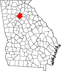
 Location in Gwinnett County and the state of Georgia | |
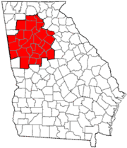
 Lawrenceville Location of Lawrenceville in Metro Atlanta | |
| Coordinates: 33°57′11″N 83°59′33″W / 33.95306°N 83.99250°WCoordinates: 33°57′11″N 83°59′33″W / 33.95306°N 83.99250°W | |
| Country | United States |
| State | Georgia |
| County | Gwinnett |
| Area | |
| • Total | 13.5 sq mi (35.0 km2) |
| • Land | 13.4 sq mi (34.7 km2) |
| • Water | 0.1 sq mi (0.3 km2) |
| Elevation | 1,066 ft (325 m) |
| Population (2010) | |
| • Total | 28,546 |
| • Density | 2,131/sq mi (822.9/km2) |
| Time zone | Eastern (EST) (UTC-5) |
| • Summer (DST) | EDT (UTC-4) |
| ZIP codes | 30042-30046, 30049 |
| Area code(s) | 404/678/770 |
| FIPS code | 13-45488[1] |
| GNIS feature ID | 0316699[2] |
| Website |
www |
Lawrenceville is a city in and the county seat of Gwinnett County, Georgia, in the United States.[3] It is a suburb of Atlanta, located approximately 30 miles (48 km) northeast of downtown. As of the 2010 census, the population of Lawrenceville was 28,546.[4] In 2015, the U.S. Census Bureau estimated the city population to be 30,493.[5] Lawrenceville has six ZIP codes (30042-30046, 30049), and it is part of the 678/770/404 telephone area code, which is used throughout metropolitan Atlanta.
History
Lawrenceville was incorporated by an act of the Georgia General Assembly on December 15, 1821. This makes Lawrenceville the second oldest city in the metropolitan Atlanta area. The city is named after Commodore James Lawrence, commander of the frigate Chesapeake during the War of 1812. Lawrence, a native of New Jersey, is probably best known today for his dying command, "Don't give up the ship!" William Maltbie, the town's first postmaster, suggested the name of "Lawrenceville".
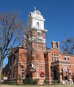
In 1821 a permanent site for the county courthouse was selected and purchased, the four streets bordering the square were laid out along with other streets in the village, and a public well was dug. Major Grace built the first permanent courthouse, a brick structure, in 1823-24 for a cost of $4,000. The courthouse presently on the square was constructed in 1885.
Courtland Winn served two terms as mayor starting in 1884 when he was 21 years old.
The two most famous people born in Lawrenceville gained their fame elsewhere. Charles Henry Smith, born in 1826, left as a young man and lived most of his life in other Georgia towns. During the Civil War he wrote humorous pieces for Atlanta newspapers under the name Bill Arp. He has been described as the South's most popular writer of the late 19th century, though he is not much read today. Ezzard Charles, born in 1921, grew up in Cincinnati, where opportunities for African-Americans were far better at the time than in the Deep South. He eventually became the World Heavyweight boxing champion by defeating Joe Louis by unanimous decision on September 27, 1950.
Another resident, Oliver Hardy, became a world-renowned comic actor, a member of the film duo Laurel and Hardy from the 1920s to the 1940s. He lived as a child in downtown Lawrenceville around 1900. But his stay was brief, because his family moved often within Georgia.

Lawrenceville was one of many venues in the nation where Hustler magazine publisher Larry Flynt faced obscenity charges in the late 1970s. On March 6, 1978, during a lunch break in his Lawrenceville trial, he and his local attorney Gene Reeves were shot by a sniper near the courthouse. Both survived, though Flynt was seriously disabled. Years later, imprisoned serial killer Joseph Paul Franklin claimed to have been the shooter, but he never produced any proof and was not charged in the case. (Franklin was executed in 2013 in Missouri for a 1977 sniper slaying.) A heavily fictionalized treatment of the Flynt shooting can be seen in the 1996 movie The People vs. Larry Flynt.
Since 1988, Lawrenceville has been the headquarters of the Presbyterian Church in America.
Geography
Lawrenceville is located in central Gwinnett County at 33°57′11″N 83°59′33″W / 33.95306°N 83.99250°W (33.953052, -83.992469).[6] According to the United States Census Bureau, the city has a total area of 13.5 square miles (35.0 km2), of which 13.4 square miles (34.7 km2) is land and 0.1 square miles (0.3 km2), or 0.83%, is water.[4]
Nearby cities are Dacula to the east, Buford to the north, Suwanee to the north-northwest, Duluth to the northwest, Norcross to the west, Lilburn to the southwest, Snellville to the south, and Grayson to the southeast.
Climate
Lawrenceville has a humid subtropical climate (Köppen climate classification Cfa).
| Climate data for Lawrenceville, Georgia | |||||||||||||
|---|---|---|---|---|---|---|---|---|---|---|---|---|---|
| Month | Jan | Feb | Mar | Apr | May | Jun | Jul | Aug | Sep | Oct | Nov | Dec | Year |
| Average high °F (°C) | 50 (10) |
55 (13) |
63 (17) |
72 (22) |
79 (26) |
85 (29) |
88 (31) |
87 (31) |
81 (27) |
71 (22) |
62 (17) |
53 (12) |
70.5 (21.4) |
| Average low °F (°C) | 31 (−1) |
32 (0) |
39 (4) |
45 (7) |
54 (12) |
63 (17) |
67 (19) |
66 (19) |
60 (16) |
49 (9) |
40 (4) |
33 (1) |
48.3 (8.9) |
| Average precipitation inches (mm) | 5.32 (135.1) |
4.39 (111.5) |
5.48 (139.2) |
3.87 (98.3) |
3.94 (100.1) |
3.78 (96) |
4.02 (102.1) |
3.71 (94.2) |
3.98 (101.1) |
3.74 (95) |
3.63 (92.2) |
3.77 (95.8) |
49.63 (1,260.6) |
| Source: [7] | |||||||||||||
Demographics
| Historical population | |||
|---|---|---|---|
| Census | Pop. | %± | |
| 1880 | 463 | — | |
| 1890 | 566 | 22.2% | |
| 1900 | 853 | 50.7% | |
| 1910 | 1,518 | 78.0% | |
| 1920 | 2,059 | 35.6% | |
| 1930 | 2,156 | 4.7% | |
| 1940 | 2,223 | 3.1% | |
| 1950 | 2,932 | 31.9% | |
| 1960 | 3,804 | 29.7% | |
| 1970 | 5,207 | 36.9% | |
| 1980 | 8,928 | 71.5% | |
| 1990 | 16,848 | 88.7% | |
| 2000 | 22,397 | 32.9% | |
| 2010 | 28,546 | 27.5% | |
| Est. 2015 | 30,493 | [5] | 6.8% |

As of 2010 Census, Lawrenceville had a population of 28,546. The median age was 32.4. The racial composition of the population was 48.0% white, 32.0% black or African American, 0.6% Native American, 1.1% Asian Indian, 4.7% other Asian, 10.3% from some other race and 3.4% from two or more races. 22.3% of the population was Hispanic or Latino of any race.2010 general profile of population and housing characteristics of Lawrenceville from the US Census.[9]
In the city the population was spread out with 26.4% under the age of 18, 11.0% from 18 to 24, 35.3% from 25 to 44, 18.2% from 45 to 64, and 9.1% who were 65 years of age or older. The median age was 32 years. For every 100 females there were 105.1 males. For every 100 females age 18 and over, there were 103.9 males.
The median income for a household in the city was $43,299, and the median income for a family was $48,557. Males had a median income of $34,263 versus $26,903 for females. The per capita income for the city was $19,649. About 11.7% of families and 24.5% of the population were below the poverty line, including 16.0% of those under age 18 and 11.9% of those age 65 or over.
Transportation
Lawrenceville can be accessed through several highways. Georgia 316 passes through Lawrenceville to Athens and connects to Interstate 85 at Exit 106. Interstate 85 South then travels through downtown Atlanta, which is roughly 30 to 35 miles away. Lawrenceville can also be accessed by US 78 (Stone Mountain Freeway) and then Scenic Highway (Georgia 124) via Snellville. Some southern unincorporated areas with Lawrenceville addresses can be accessed by Ronald Reagan Parkway. Other highways that pass through Lawrenceville are US 29, GA 8, GA 20, and GA 120.
Lawrenceville is home to Gwinnett's only public airport, Gwinnett County Airport-Briscoe Field. With its daytime control tower, several FBOs (Fixed-Base Operators), and flight-training schools, Brisco Field primarily serves general aviation and some commercial aircraft.
Xpress GA/ RTA Commuter buses and Gwinnett County Transit serve the city.
Education
Gwinnett County Public Schools operates public schools.
Schools with Lawrenceville mailing address
The following is a list of schools with a Lawrenceville mailing address, with its high school cluster in parenthesis.
Elementary schools
- J.A. Alford Elementary School (Discovery)
- Cedar Hill Elementary School (Discovery)
- Lawrenceville Elementary School (Central Gwinnett)
- Simonton Elementary School (Central Gwinnett)
- Margaret Winn Holt Elementary School (Central Gwinnett)
- Benefield Elementary (Discovery)
- Woodward Mill Elementary School (Mountain View)
- Lovin Elementary School (Archer)
- K.E. Taylor Elementary School (Collins Hill)
- McKendree Elementary School (Collins Hill)
- Jenkins Elementary School (Central Gwinnett)
- Rock Springs Elementary School (Collins Hill)
- Corley Elementary School (Berkmar)
Middle schools
- Moore Middle School (Central Gwinnett)
- J.E. Richards Middle School (Discovery)
- Creekland Middle School (Collins Hill)
- Jordan Middle School (Central Gwinnett)
High schools
- Discovery High School
- Central Gwinnett High School
- Phoenix High School
- Mountain View High School
- Archer High School
- Gwinnett School of Mathematics, Science, and Technology
Other schools
- Gwinnett InterVention Education (GIVE) Center East (Alternative School)
- Hooper Renwick School
Colleges and university
Within Lawrenceville are two public colleges:
Libraries
Gwinnett County Public Library operates the Collins Hill, Five Forks and Lawrenceville branches. The Lawrenceville and Collins Hill branches are in an unincorporated area.[10]
Hospitals
Lawrenceville is home to Gwinnett Medical Center. GMC is a non-profit, 500-bed health care network based in Gwinnett County. It comprises two hospitals, plus several supporting medical facilities, with more than 4,300 employees and more than 800 affiliated physicians. The flagship campus of GMC is located in Lawrenceville near the intersection of Hwy. 316 and Duluth Highway 120.
Prior to the opening of Gwinnett Medical Center in 1984, the area was served by Button Gwinnett Hospital, which was later converted to an inpatient mental health and substance abuse treatment facility.
Downtown

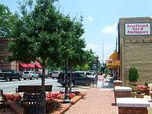
Historically significant buildings in downtown Lawrenceville include the Gwinnett Historic Courthouse and Lawrenceville Female Seminary. Also downtown are various landmarks and antique locations. Lawrenceville's revitalization plan was strengthened in 2005 when the city crafted a unique partnership with the Aurora Theatre (Gwinnett county's only professional theatre), which relocated from the nearby town of Duluth to a permanent site in downtown Lawrenceville in May 2007 for the opening of its eleventh season. The Aurora Theatre also conducts Lawrenceville Ghost Tours—a 90-minute walking tour of the historic downtown area led by professional storytellers. Ghost tour guides recount town lore and legends including Lawrenceville's role in the trial of Larry Flynt and the kidnapping of Barbara Jane Mackle.
Economy
Scientific Atlanta, now owned by Cisco Systems, is based near Lawrenceville.
Atlanta Biologicals is located in Lawrenceville.
Peach State Federal Credit Union headquartered in Lawrenceville serves 39,800 members across Barrow, Clarke, DeKalb, Forsyth, Gwinnett, Jackson, Oconee and Walton Counties.
Sports
The AAA minor league baseball Gwinnett Braves of the International League play at Coolray Field.
Notable people
- Moisés Arias, television and film actor
- Jonathan Babineaux, NFL defensive tackle for the Atlanta Falcons
- Ezzard Charles, former pro boxer
- Wes Chatham, actor "The Help" and "Barbershop"
- EJay Day, finalist on first season of American Idol
- Carder England, pro poker player
- Rachel Farley, country music singer
- Jennifer Ferrin, actress
- Rachel G. Fox, teen actress
- Jeff Francoeur, right fielder for the Atlanta Braves
- Hamilton Jordan, Chief of Staff to President Jimmy Carter
- Michael Kelly, television actor
- Jonathan Massaquoi, NFL defensive end for the Tennessee Titans
- Brian McCann, MLB catcher for the New York Yankees
- Migos, hiphop/ rap group
- Grace Min, tennis player
- Maya Moore, WNBA forward for the Minnesota Lynx
- Raju Rai, former badminton national champion who qualified for the 2008 Olympics
- Junior Samples, comedian
- Christin Stewart, MLB player in the Detroit Tigers organization
- Darius Walker, former NFL running back
- Courtland Winn, 19th century politician and lawyer
- Rob Woodall, politician and current member of the U.S. House of Representatives
- Walker Zimmerman, professional soccer player
References
- ↑ "American FactFinder". United States Census Bureau. Retrieved 2008-01-31.
- ↑ "US Board on Geographic Names". United States Geological Survey. 2007-10-25. Retrieved 2008-01-31.
- ↑ "Find a County". National Association of Counties. Retrieved 2011-06-07.
- 1 2 "Geographic Identifiers: 2010 Demographic Profile Data (G001): Lawrenceville city, Georgia". American Factfinder. U.S. Census Bureau. Retrieved November 30, 2016.
- 1 2 "Annual Estimates of the Resident Population for Incorporated Places: April 1, 2010 to July 1, 2015". Retrieved July 2, 2016.
- ↑ "US Gazetteer files: 2010, 2000, and 1990". United States Census Bureau. 2011-02-12. Retrieved 2011-04-23.
- ↑ "Average weather for Lawrenceville". Weather.com. Retrieved 15 August 2009.
- ↑ "Census of Population and Housing". Census.gov. Retrieved June 4, 2015.
- ↑ "2010 Census data for LAWRENCEVILLE, GA". zipcodes.com. Datasheer, L.L.C. Retrieved 10 July 2014.
- ↑ "Hours & Locations." Gwinnett County Public Library. Retrieved on May 30, 2014.
External links
| Wikivoyage has a travel guide for Lawrenceville. |
- City of Lawrenceville official website
- Georgia.gov: Lawrenceville
- Web site of the Courts of Gwinnett County
- Gwinnett County Public Schools
- Gwinnett County Public Library
- Hog Mountain Baptist Church historical marker


