List of Scheduled Monuments in Swansea

The city and county of Swansea covers, in addition to the port city of Swansea, areas of upland to the north, and the Gower peninsula to the west. It is on Gower that the earliest Scheduled monuments are found. Three sites have evidence of habitation from the Paleolithic, a time before the last Ice Age. These include the oldest rock painting in Britain and the earliest known burial in Western Europe. There are in total 124 scheduled sites. Prehistoric sites of many sorts are found, particularly on Gower. 64 pre-historic sites are from Paleolithic to Iron Age dates, and include caves, burial mounds and tombs, cairns, defensive enclosures, hillforts and promentary forts. Roman and early medieval sites, by contrast are scarce. The post-Norman Medieval period, by contrast, has 26 sites, 17 of them castles or other defensive monuments. The other 9 are all ecclesiastical monuments. The 26 post-medieval monuments are more diverse, including industrial and maritime sites, but also leats, quarries, a mill and even an observatory and an orchid house. All of the Swansea administrative area lies within the historic county of Glamorgan.
Scheduled Ancient Monuments (SAMs) have statutory protection. It is illegal to disturb the ground surface or any standing remains. The compilation of the list is undertaken by Cadw Welsh Historic Monuments, which is an executive agency of the National Assembly of Wales.[1] The list of scheduled monuments below is supplied by Cadw[2] with additional material from RCAHMW and Glamorgan-Gwent Archaeological Trust.
Scheduled Monuments in Swansea
| Image | Name | Site type | Community | Location | Details | Period | SAM No & Refs |
|---|---|---|---|---|---|---|---|
| Longhole Cave | Cave | Port Eynon | 51°32′35″N 4°14′05″W / 51.5431°N 4.2348°W, SS451850 |
Cave with Paleolithic flint tools | Prehistoric (Paleolithic) |
GM391 [3] | |
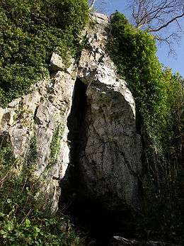
 |
Paviland Cave | Cave | Rhossili | 51°33′01″N 4°15′19″W / 51.5502°N 4.2552°W, SS437859 |
Paleolithic burial cave known as 'Goat's Cave'. Buried 33,000 years ago, the remains found in 1823 are the oldest known ceremonial burial in Western Europe. | Prehistoric (Upper Paleolithic) |
GM504 [4] |
| Cathole Cave | Cave | Ilston | 51°35′24″N 4°06′45″W / 51.5899°N 4.1124°W, SS537900 |
Cave on Gower, occupied over 30,000 years from Palaeolithic to Medieval times. In 2010 engraved rock art was found of a reindeer, dated to upwards of 12,000 BC, making it the oldest rock art in the British Isles. | Prehistoric (Upper Palaeolithic) |
GM349 [5] | |
| Cefn Bryn Burial Chamber | Chambered long cairn | Ilston | 51°34′41″N 4°09′18″W / 51.5781°N 4.1551°W, SS507887 |
A Chambered long cairn towards the base of the Cenf Bryn ridge | Prehistoric (Neolithic) |
GM167 [6] | |
 |
Parc Cwm long cairn (Parc le Breos) |
Chambered long cairn | Ilston | 51°35′18″N 4°06′46″W / 51.5883°N 4.1128°W, SS537898 |
Chambered tomb in which human remains were interred over a 300 to 800-year period in the Neolithic. Discovered in 1869, and brought into public ownership and partly reconstructed in 1961, it had a detailed excavation in 1998. | Prehistoric (Neolithic) |
GM122 [7] |
| Penmaen Burrows Burial Chamber | Chambered tomb | Ilston | 51°34′22″N 4°07′13″W / 51.5728°N 4.1203°W, SS531881 |
Megalithic burial chamber first excavated in 1860. Now being inundated by sand dunes. | Prehistoric (Neolithic) |
GM123 [8] | |
| Sweyne's Howe Chambered Cairns | Chambered tomb | Llangennith, Llanmadoc and Cheriton | 51°35′06″N 4°16′50″W / 51.585°N 4.2805°W, SS421898 |
Three Neolithic and later chambered tombs in varying states of collapse, on the upper eastern slopes of Rhossili Down. | Prehistoric (Neolithic) |
GM027 [9] | |
| Two Burial Chambers on Graig Fawr | Chambered tomb | Pontardulais | 51°44′14″N 4°00′59″W / 51.7373°N 4.0164°W, SN608062 |
Prehistoric (Neolithic) |
GM513 [10] | ||
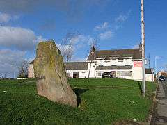 |
Bon y Maen Standing Stone | Standing stone | Bonymaen | 51°38′25″N 3°54′40″W / 51.6404°N 3.9112°W, SS678952 |
A sandstone monolith on the eastern edge of Swansea, on a ridge between the Tawe valley and Crymlyn Bog. | Prehistoric (Bronze Age) |
GM177 [11] |
| Cockett standing stone | Standing stone | Cockett | 51°38′06″N 3°59′16″W / 51.6351°N 3.9877°W, SS625947 |
Prehistoric |
GM582 [12] | ||
| Llethrid Tooth Cave | Cave | Ilston | 51°35′52″N 4°07′17″W / 51.5979°N 4.1213°W, SS531909 |
Early Bronze Age ossuary in a cave 1.4 km from Parc Cwm long cairn, and may be contemporary with later burials there. | Prehistoric (Bronze Age) |
GM284 [13] | |
 |
Culver Hole | Cave | Llangennith, Llanmadoc and Cheriton | 51°36′46″N 4°18′14″W / 51.6127°N 4.3038°W, SS405929 |
Coastal cave near Burry Holms and Three Chimneys, in which were found human remains and artefacts from all periods from Bronze Age through to the 9th century AD. | Prehistoric (Bronze Age onwards) |
GM087 [14] |
 |
Arthur's Stone, Cefn Bryn | Chambered tomb | Llanrhidian Lower | 51°35′37″N 4°10′46″W / 51.5936°N 4.1794°W, SS491905 |
Double stone chambered tomb, capped by a huge capstone, which probably always was exposed above the mound. Also called Maen Ceti, it may have been in situ before the tomb was excavated under it. | Prehistoric (Bronze Age) |
GM003 [15] |
| Lower Greyhound Inn Standing Stones | Standing stone | Llanrhidian Lower | 51°36′23″N 4°11′11″W / 51.6065°N 4.1865°W, SS486920 |
Prehistoric |
GM152 [16] | ||
| Samson's Jack | Standing stone | Llanrhidian Lower | 51°36′27″N 4°12′05″W / 51.6075°N 4.2013°W, SS476921 |
Standing stone, 3.2m high, embedded in a field boundary bank. It is also known as Mansel Jank | Prehistoric (Bronze Age) |
GM133 [17] | |
| Ty'r Coed standing stone | Standing stone | Llanrhidian Lower | 51°36′12″N 4°12′09″W / 51.6033°N 4.2025°W, SS475916 |
Standing stone, 2.5m high, embedded in a field boundary bank. | Prehistoric (Bronze Age) |
GM151 [18] | |
| Mynydd Pysgodlyn Round Barrow | Round barrow | Mawr | 51°43′31″N 3°58′39″W / 51.7254°N 3.9775°W, SN635048 |
Prehistoric |
GM202 [19] | ||
| Berry Ringwork | Ringwork | Port Eynon | 51°34′27″N 4°12′21″W / 51.5742°N 4.2058°W, SS472884 |
Prehistoric |
GM178 [20] | ||
| Burry Lesser Standing Stone | Standing stone | Port Eynon | 51°35′19″N 4°13′17″W / 51.5885°N 4.2213°W, SS462900 |
Prehistoric |
GM150 [21] | ||
| Burry Menhir | Standing stone | Port Eynon | 51°35′19″N 4°13′07″W / 51.5885°N 4.2186°W, SS464900 |
Prehistoric |
GM134 [22] | ||
| Burry Standing Stone | Standing stone | Port Eynon | 51°34′50″N 4°12′40″W / 51.5806°N 4.2112°W, SS468891 |
Prehistoric |
GM191 [23] | ||
| Newton henge, cropmark | Henge | Port Eynon | 51°34′16″N 4°14′37″W / 51.5711°N 4.2437°W, SS446881 |
Prehistoric |
GM580 [24] | ||
| Cave 40m SE of Deborah's Hole | Cave site | Rhossili | 51°33′13″N 4°15′36″W / 51.5537°N 4.26°W, SS434862 |
Natural cave overlooking the seas, with a Bronze Age mound at the entrance | Prehistoric (Bronze Age) |
GM622 [25] | |
| Round Cairn with Cist on Mynydd Drumau | Round cairn | Clydach, (also Dyffryn Clydach), (see also Neath Port Talbot) | 51°41′15″N 3°50′47″W / 51.6876°N 3.8465°W, SN724003 |
Prehistoric |
GM387 [26] | ||
| Cairns on Cefn Bryn | Round cairn | Ilston | 51°34′46″N 4°08′11″W / 51.5795°N 4.1365°W, SS520889 |
Prehistoric |
GM038 [27] | ||
| Cefn Bryn Burnt Mound | Burnt mound | Ilston | 51°34′56″N 4°08′20″W / 51.5823°N 4.1389°W, SS519892 |
Prehistoric |
GM543 [28] | ||
| Burnt Mound on Rhossili Down | Burnt mound | Llangennith, Llanmadoc and Cheriton | 51°35′29″N 4°17′01″W / 51.5915°N 4.2836°W, SS419905 |
Prehistoric |
GM476 [29] | ||
| Llanmadoc Hill, cairn on E end of | Round cairn | Llangennith, Llanmadoc and Cheriton | 51°36′41″N 4°15′16″W / 51.6115°N 4.2544°W, SS439927 |
Prehistoric |
GM579 [30] | ||
| Llanmadoc Hill, cairn on W end of | Round cairn | Llangennith, Llanmadoc and Cheriton | 51°36′31″N 4°16′08″W / 51.6087°N 4.269°W, SS429924 |
Prehistoric |
GM578 [31] | ||
| Round Cairn on Bessie's Meadow | Round cairn | Llangennith, Llanmadoc and Cheriton | 51°35′15″N 4°17′02″W / 51.5874°N 4.2838°W, SS418900 |
Prehistoric |
GM498 [32] | ||
| Burnt Mound 300m SW of Arthur's Stone | Burnt mound | Llanrhidian Lower | 51°35′32″N 4°10′58″W / 51.5922°N 4.1829°W, SS488904 |
Prehistoric |
GM436 [33] | ||
| Burnt Mound North of Arthur's Stone | Burnt mound | Llanrhidian Lower | 51°35′47″N 4°10′54″W / 51.5964°N 4.1817°W, SS489908 |
Prehistoric |
GM544 [34] | ||
| Pen-y-Crug Round Barrow | Round barrow | Llanrhidian Lower | 51°36′05″N 4°09′05″W / 51.6014°N 4.1514°W, SS510913 |
Prehistoric |
GM153 [35] | ||
| Round Cairn W of Arthur's Stone | Round cairn | Llanrhidian Lower | 51°35′37″N 4°10′51″W / 51.5936°N 4.1809°W, SS490905 |
Prehistoric |
GM196 [36] | ||
| Cairn 250m SW of Banc Llyn-Mawr | Round cairn | Mawr | 51°44′42″N 3°59′29″W / 51.7451°N 3.9914°W, SN626070 |
Prehistoric |
GM384 [37] | ||
| Pant-y-Ffa Round Cairn | Round cairn | Mawr | 51°42′22″N 4°00′03″W / 51.706°N 4.0009°W, SN618027 |
Prehistoric |
GM201 [38] | ||
| Ring Cairn on Tor Clawdd | Ring cairn | Mawr | 51°44′23″N 3°55′38″W / 51.7396°N 3.9271°W, SN670062 |
Prehistoric |
GM353 [39] | ||
| Garn Goch Round Barrow | Round barrow | Penllergaer | 51°39′51″N 4°01′03″W / 51.6641°N 4.0176°W, SS605980 |
Prehistoric |
GM199 [40] | ||
| Rhossili Down Round Cairns | Round cairn | Rhossili | 51°34′41″N 4°16′51″W / 51.578°N 4.2807°W, SS420890 |
Prehistoric |
GM194 [41] | ||
| Bishopston Valley Camp | Promontory Fort - inland | Bishopston | 51°34′15″N 4°03′57″W / 51.5709°N 4.0659°W, SS569878 |
Prehistoric |
GM126 [42] | ||
| Caswell Cliff Fort | Promontory Fort - coastal | Bishopston | 51°34′09″N 4°02′19″W / 51.5693°N 4.0387°W, SS588875 |
Prehistoric |
GM132 [43] | ||
| Burry Holms Camp | Promontory Fort - coastal | Llangennith, Llanmadoc and Cheriton | 51°36′34″N 4°18′49″W / 51.6094°N 4.3135°W, SS398925 |
Prehistoric |
GM088 [44] | ||
| Enclosure on Rhossili Down | Enclosure | Llangennith, Llanmadoc and Cheriton | 51°35′06″N 4°16′38″W / 51.585°N 4.2773°W, SS423898 |
Prehistoric |
GM487 [45] | ||
| The Bulwark, Llanmadoc Hill | Hillfort | Llangennith, Llanmadoc and Cheriton | 51°36′43″N 4°15′00″W / 51.612°N 4.2499°W, SS443927 |
Prehistoric |
GM061 [46] | ||
| Three Camps on Harding's Down | Hillfort | Llangennith, Llanmadoc and Cheriton | 51°35′34″N 4°15′28″W / 51.5929°N 4.2577°W, SS437906 |
Prehistoric |
GM060 [47] | ||
| Earthwork 108m NNW of Fforest Newydd | Enclosure | Llangyfelach | 51°41′46″N 3°58′28″W / 51.6962°N 3.9745°W, SS636015 |
Prehistoric |
GM308 [48] | ||
| Dan-y-Lan Camp | Enclosure | Llanrhidian Higher | 51°38′32″N 4°05′26″W / 51.6422°N 4.0906°W, SS554957 |
Prehistoric |
GM268 [49] | ||
| Gron-Gaer | Enclosure | Llanrhidian Higher | 51°37′58″N 4°05′46″W / 51.6329°N 4.096°W, SS550947 |
Prehistoric |
GM197 [50] | ||
| Pen-y-Gaer | Hillfort | Llanrhidian Higher | 51°38′22″N 4°06′59″W / 51.6394°N 4.1163°W, SS536955 |
Prehistoric |
GM198 [51] | ||
| Cil Ifor Promontory Fort | Promontory Fort - inland | Llanrhidian Lower | 51°36′35″N 4°09′34″W / 51.6098°N 4.1594°W, SS505923 |
Prehistoric |
GM124 [52] | ||
| Stembridge Camp | Hillfort | Llanrhidian Lower | 51°36′04″N 4°12′39″W / 51.6011°N 4.2108°W, SS469914 |
Prehistoric |
GM125 [53] | ||
| Ring Cairn on Craig Fawr | Earthwork (unclassified) | Mawr | 51°44′30″N 3°59′15″W / 51.7416°N 3.9876°W, SN628066 |
Prehistoric |
GM380 [54] | ||
| High Pennard | Earthwork (unclassified) | Pennard | 51°33′37″N 4°04′03″W / 51.5603°N 4.0674°W, SS567866 |
Prehistoric |
GM045 [55] | ||
| Earthwork on Graig Fawr | Hillfort | Pontardulais | 51°44′36″N 4°00′10″W / 51.7433°N 4.0027°W, SN618068 |
Prehistoric |
GM386 [56] | ||
| Earthwork 450m SW of Llanddewi Church | Enclosure | Port Eynon | 51°34′36″N 4°13′47″W / 51.5767°N 4.2298°W, SS455783 |
Prehistoric |
GM334 [57] | ||
| Reynoldston Camp | Enclosure | Reynoldston | 51°35′15″N 4°11′26″W / 51.5876°N 4.1905°W, SS483899 |
Prehistoric |
GM195 [58] | ||
| Deborah's Hole Camp | Promontory Fort - coastal | Rhossili | 51°33′16″N 4°15′48″W / 51.5545°N 4.2633°W, SS431863 |
Prehistoric |
GM128 [59] | ||
| Horse Cliff Camp | Promontory Fort - coastal | Rhossili | 51°33′05″N 4°15′31″W / 51.5515°N 4.2586°W, SS435860 |
Prehistoric |
GM192 [60] | ||
| Lewes Castle Promontory Fort | Promontory Fort - coastal | Rhossili | 51°33′45″N 4°17′20″W / 51.5625°N 4.2888°W, SS414873 |
Prehistoric |
GM470 [61] | ||
| Old Castle Camp | Promontory Fort - coastal | Rhossili | 51°34′06″N 4°17′48″W / 51.5684°N 4.2966°W, SS409880 |
Prehistoric |
GM193 [62] | ||
| Paviland Camp | Promontory Fort - coastal | Rhossili | 51°33′03″N 4°15′20″W / 51.5509°N 4.2555°W, SS437859 |
Prehistoric |
GM131 [63] | ||
 |
Promontory Fort on Worms Head | Promontory Fort - coastal | Rhossili | 51°33′50″N 4°19′09″W / 51.564°N 4.3193°W, SS393875 |
Prehistoric |
GM492 [64] | |
| Thurba Camp | Promontory Fort - coastal | Rhossili | 51°33′37″N 4°16′42″W / 51.5603°N 4.2783°W, SS421870 |
Prehistoric |
GM127 [65] | ||
| Earthwork on Kilvey Hill | Enclosure | St Thomas | 51°38′08″N 3°55′03″W / 51.6356°N 3.9176°W, SS673947 |
Prehistoric |
GM315 [66] | ||
| Church Hill Romano-British Enclosure | Enclosure | Ilston | 51°35′18″N 4°06′52″W / 51.5883°N 4.1145°W, SS536898 |
Roman |
GM603 [67] | ||
| Mynydd Carn-Goch Roman Earthworks | Practice camp | Llwchwr | 51°39′22″N 4°00′48″W / 51.6562°N 4.0134°W, SS608971 |
Roman |
GM269 [68] | ||
| Roman Practice Camp on Stafford Common | Practice camp | Llwchwr | 51°39′24″N 4°02′15″W / 51.6568°N 4.0376°W, SS591973 |
Roman |
GM502 [69] | ||
 |
Medieval Hermitage Site on Burry Holms | Hermitage | Llangennith, Llanmadoc and Cheriton | 51°36′33″N 4°18′38″W / 51.6093°N 4.3105°W, SS401925 |
Early Medieval |
GM473 [70] | |
| St Cennydd's Church Cross-shaft | Cross shaft | Llangennith, Llanmadoc and Cheriton | 51°35′59″N 4°16′12″W / 51.5996°N 4.27°W, SS428914 |
Early Medieval |
GM621 [71] | ||
| St Madoc's Church Cross-incised Stones | Cross | Llangennith, Llanmadoc and Cheriton | 51°37′05″N 4°15′23″W / 51.618°N 4.2564°W, SS438934 |
Early Medieval |
GM223 [72] | ||
| Llangyfelach Cross-Base | Cross | Llangyfelach | 51°40′22″N 3°57′32″W / 51.6728°N 3.959°W, SS646989 |
Early Medieval |
GM299 [73] | ||
| Cross-Slab from Woodlands, Stout Hall (now in St George's Church, Reynoldston) | Cross-marked stone | Reynoldston | 51°35′19″N 4°11′46″W / 51.5885°N 4.1961°W, SS479900 |
Early Medieval |
GM089 [74] | ||
| Chantry Acre medieval chapel | Chapel | Bishopston | 51°34′27″N 4°03′19″W / 51.5741°N 4.0553°W, SS576881 |
Medieval |
GM548 [75] | ||
| Old Castle Camp | Ringwork | Bishopston | 51°35′28″N 4°02′54″W / 51.591°N 4.0484°W, SS582900 |
Medieval |
GM154 [76] | ||
| Original Swansea Castle | Castle | Castle | 51°37′16″N 3°56′29″W / 51.6211°N 3.9414°W, SS657931 |
Medieval |
GM441 [77] | ||
 |
Swansea Castle |
Castle | Castle | 51°37′14″N 3°56′28″W / 51.6205°N 3.9411°W, SS657930 |
Medieval |
GM012 [78] | |
| St Michael's Chapel, Cwrt-y-Carne | Chapel | Gorseinon | 51°41′04″N 4°04′02″W / 51.6844°N 4.0672°W, SN571004 |
Medieval |
GM363 [79] | ||
| Llandeilo Castle Mound | Motte | Grovesend | 51°42′18″N 4°02′47″W / 51.7049°N 4.0465°W, SN586026 |
Medieval |
GM200 [80] | ||
| Penmaen Burrows Church | Church | Ilston | 51°34′23″N 4°07′14″W / 51.5731°N 4.1206°W, SS531881 |
Medieval |
GM130 [81] | ||
| Penmaen Burrows Ringwork | Ringwork | Ilston | 51°34′19″N 4°07′00″W / 51.572°N 4.1166°W, SS534880 |
Medieval |
GM129 [82] | ||
| Trinity Well and Remains of Chapel | Chapel | Ilston | 51°35′07″N 4°05′24″W / 51.5853°N 4.09°W, SS552894 |
Medieval |
GM158 [83] | ||
| Bovehill Castle | Manor | Llangennith, Llanmadoc and Cheriton | 51°37′01″N 4°13′11″W / 51.6169°N 4.2196°W, SS464932 |
Medieval |
GM149 [84] | ||
| North Hill Tor Camp | Enclosure | Llangennith, Llanmadoc and Cheriton | 51°37′18″N 4°14′11″W / 51.6217°N 4.2363°W, SS452937 |
Medieval |
GM062 [85] | ||
| Llanelen Chapel Site | Chapel | Llanrhidian Lower | 51°37′09″N 4°09′06″W / 51.6193°N 4.1517°W, SS511933 |
Medieval |
GM376 [86] | ||
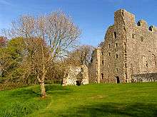
 |
Weobley Castle |
Castle | Llanrhidian Lower | 51°36′46″N 4°11′57″W / 51.6128°N 4.1993°W, SS478927 |
Medieval |
GM010 [87] | |
 |
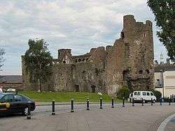
Loughor Castle |
Castle | Llwchwr | 51°39′44″N 4°04′38″W / 51.6622°N 4.0771°W, SS564979 |
Medieval |
GM046 [88] | |
| Cae Castell (Rhyndwyclydach Medieval Earthwork) | Earthwork (unclassified) | Mawr | 51°43′34″N 3°53′32″W / 51.7261°N 3.8921°W, SN694047 |
Medieval |
GM439 [89] | ||
| Penlle'r Castell | Castle | Mawr | 51°46′09″N 3°56′08″W / 51.7691°N 3.9356°W, SN665096 |
Medieval |
GM255 [90] | ||
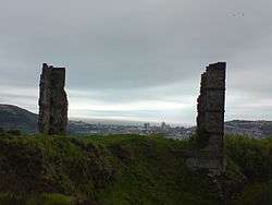
 |
Oystermouth Castle | Castle | Mumbles | 51°34′38″N 4°00′10″W / 51.5771°N 4.0027°W, SS613883 |
Medieval |
GM007 [91] | |
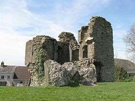
 |
Pennard Castle & Church | Castle | Pennard | 51°34′35″N 4°06′09″W / 51.5765°N 4.1026°W, SS544885 |
Medieval |
GM044 [92] | |
| Norton Camp | Ringwork | Penrice | 51°33′34″N 4°10′39″W / 51.5595°N 4.1775°W, SS491867 |
Medieval |
GM157 [93] | ||
 |
Oxwich Castle |
Castle | Penrice | 51°33′20″N 4°10′06″W / 51.5555°N 4.1683°W, SS497862 |
Medieval |
GM043 [94] | |
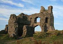
 |
Penrice Castle | Castle | Penrice | 51°34′31″N 4°10′13″W / 51.5752°N 4.1702°W, SS497884 |
Medieval |
GM047 [95] | |
| Penrice Ringwork | Ringwork | Penrice | 51°34′09″N 4°10′37″W / 51.5693°N 4.1769°W, SS492878 |
Medieval |
GM053 [96] | ||
| Tower NE of Oxwich Castle | Tower | Penrice | 51°33′22″N 4°10′02″W / 51.5562°N 4.1672°W, SS498863 |
Medieval |
GM472 [97] | ||
| Site of St Teilo's Old Parish Church | Church | Pontardulais | 51°42′28″N 4°02′59″W / 51.7079°N 4.0497°W, SN584030 |
Site of St Teilo's Old Parish Church, Llandeilo, Talybont. The church was removed to St Fagans National History Museum | Medieval |
GM415 [98] | |
| St Maurice's Church | Church | Port Eynon | 51°34′46″N 4°12′40″W / 51.5794°N 4.2111°W, SS468890 |
Medieval |
GM156 [99] | ||
| Remains of Medieval Building & Church at Rhossili | Building (Unclassified) | Rhossili | 51°34′18″N 4°17′16″W / 51.5716°N 4.2879°W, SS415883 |
Medieval |
GM414 [100] | ||
| Scott's Pit Engine House & Traces of Ancillary Buildings | Engine house | Birchgrove | 51°40′06″N 3°53′07″W / 51.6683°N 3.8854°W, SS697982 |
Post-Medieval/Modern |
GM336 [101] | ||
| St Peter's Chapel & Well, Caswell Bay | Chapel | Bishopston | 51°34′35″N 4°02′08″W / 51.5764°N 4.0355°W, SS590883 |
Post-Medieval/Modern |
GM374 [102] | ||
| Morfa Bridge and Quays | Bridge | Bonymaen | 51°38′30″N 3°55′55″W / 51.6418°N 3.9319°W, SS664954 |
Post-Medieval/Modern |
GM392 [103] | ||
| Clydach Upper Forge | Industrial monument | Clydach | 51°42′03″N 3°54′05″W / 51.7009°N 3.9015°W, SN686019 |
Post-Medieval/Modern |
GM497 [104] | ||
| Melin Mynach, Gorseinon | Mill | Gorseinon | 51°40′21″N 4°02′12″W / 51.6726°N 4.0366°W, SS592990 |
Post-Medieval/Modern |
GM501 [105] | ||
| Parc le Breos Limekiln and Quarries | Limekiln | Ilston | 51°35′19″N 4°06′43″W / 51.5887°N 4.1119°W, SS537898 |
Post-Medieval/Modern |
GM536 [106] | ||
 |
Industrial monument | Landore | 51°38′15″N 3°56′06″W / 51.6374°N 3.9351°W, SS661949 |
Post-Medieval/Modern |
GM483 [107] | ||
| Landore New Quay | Quay | Landore | 51°38′45″N 3°56′03″W / 51.6459°N 3.9341°W, SS662958 |
Post-Medieval/Modern |
GM484 [108] | ||
 |
Morris Castle | Building (Unclassified) | Landore | 51°39′01″N 3°56′20″W / 51.6504°N 3.9389°W, SS659964 |
Post-Medieval/Modern |
GM371 [109] | |
 |
Whiteford Lighthouse | Lighthouse | Llangennith, Llanmadoc and Cheriton | 51°39′09″N 4°15′03″W / 51.6526°N 4.2509°W, SS443972 |
Iron Lighthouse at Whitford Point | Post-Medieval/Modern |
GM407 [110] |
| Penclawdd Sea Dock and Canal | Dockyard | Llanrhidian Higher | 51°38′41″N 4°05′36″W / 51.6447°N 4.0933°W, SS552960 |
Post-Medieval/Modern |
GM398 [111] | ||
 |
Gwernllwynchwyth Engine House | Engine house | Llansamlet | 51°39′55″N 3°53′06″W / 51.6653°N 3.8849°W, SS697979 |
Post-Medieval/Modern |
GM430 [112] | |
| Townshend's Great Leat & Waggonway | Industrial monument | Llansamlet | 51°39′53″N 3°53′10″W / 51.6647°N 3.8862°W, SS696978 |
Post-Medieval/Modern |
GM468 [113] | ||
| Clyne Valley Shaft Mounds | Coal Mine | Mumbles | 51°36′31″N 4°00′34″W / 51.6086°N 4.0095°W, SS609918 |
Post-Medieval/Modern |
GM455 [114] | ||
 |
Clyne Wood Arsenic & Copper Works | Industrial monument | Mumbles | 51°35′59″N 4°00′05″W / 51.5996°N 4.0014°W, SS614908 |
Post-Medieval/Modern |
GM475 [115] | |
| Clyne Wood Coal Level | Coal Mine | Mumbles | 51°36′10″N 4°00′15″W / 51.6029°N 4.0043°W, SS612912 |
Post-Medieval/Modern |
GM464 [116] | ||
 |
Clyne Wood Colliery Steam Winding Machine | Industrial monument | Mumbles | 51°36′35″N 4°01′07″W / 51.6096°N 4.0185°W, SS603920 |
Post-Medieval/Modern |
GM469 [117] | |
| Ynys Pit & Leat | Aqueduct | Mumbles | 51°36′37″N 4°00′15″W / 51.6103°N 4.0042°W, SS613920 |
Post-Medieval/Modern |
GM461 [118] | ||
| Limestone Quarry and Kiln at Oxwich | Limekiln | Penrice | 51°33′24″N 4°10′03″W / 51.5566°N 4.1676°W, SS498864 |
Post-Medieval/Modern |
GM542 [119] | ||
| Culver Hole Dovecot | Dovecote | Port Eynon | 51°32′22″N 4°12′51″W / 51.5394°N 4.2141°W, SS465845 |
Post-Medieval/Modern |
GM325 [120] | ||
| The Salthouse, Port Eynon | Saltworks | Port Eynon | 51°32′23″N 4°12′30″W / 51.5398°N 4.2084°W, SS469846 |
Post-Medieval/Modern |
GM471 [121] | ||
| Foxhole River Staithes | Staithes | St Thomas | 51°37′49″N 3°56′00″W / 51.6302°N 3.9332°W, SS662941 |
Post-Medieval/Modern |
GM482 [122] | ||
| White Rock Copper Works | Industrial monument | St Thomas | 51°38′07″N 3°56′00″W / 51.6354°N 3.9333°W, SS662947 |
Post-Medieval/Modern |
GM481 [123] | ||
| Penllergaer Orchideous House | Garden building | Penllergaer | 51°40′16″N 3°59′28″W / 51.671°N 3.991°W, SS624987 |
Post Medieval/Modern |
GM596 [124] | ||
 |
Remains of Astronomical Observatory at Penllergaer | Observatory | Penllergaer | 51°40′25″N 3°59′36″W / 51.6737°N 3.9933°W, SS622990 |
Post-Medieval/Modern |
GM410 [125] | |
| Oxwich Bay Coast Defence/Chain Home Low Radar Station | Radar Station | Penrice | 51°32′37″N 4°09′06″W / 51.5435°N 4.1518°W, SS508849 |
Post-Medieval/Modern |
GM602 [126] | ||
See also
- List of Cadw properties
- List of castles in Wales
- List of hill forts in Wales
- Historic houses in Wales
- List of monastic houses in Wales
- List of museums in Wales
- List of Roman villas in Wales
References
- Coflein is the online database of RCAHMW: Royal Commission on the Ancient and Historical Monuments of Wales, GGAT is the Glamorgan-Gwent Archaeological Trust, Cadw is the Welsh Historic Monuments Agency
- ↑ Cadw: Ancient Monuments and Scheduling. Accessed 25 April 2013
- ↑ Cadw will send their list as a spreadsheet, or other electronic formats, on request, as indicated at www.whatdotheyknow.com. This list uses information dated May 2012
- ↑ coflein NPRN: 305467. GGAT PRN: 00156w. Cadw SAM: GM391: Longhole Cave
- ↑ coflein NPRN: 300251. GGAT PRN: 04802w. Cadw SAM: GM504: Paviland Cave
- ↑ coflein NPRN: 305612. GGAT PRN: 00231w. Cadw SAM: GM349: Cat Hole Cave
- ↑ coflein NPRN: 94594. GGAT PRN: 00273w. Cadw SAM: GM167: Cefn Bryn Burial Chamber
- ↑ coflein NPRN: 93072. GGAT PRN: 00251w. Cadw SAM: GM122: Parc le Breos Burial Chamber
- ↑ coflein NPRN: 94571. GGAT PRN: 00250w. Cadw SAM: GM123: Penmaen Burrows Burial Chamber
- ↑ coflein NPRN: 93013. GGAT PRN: 00122w. Cadw SAM: GM027: Sweyne's Howe Chambered Cairns
- ↑ coflein NPRN: 91900. GGAT PRN: 00924w. Cadw SAM: GM513: Two Burial Chambers on Graig Fawr
- ↑ coflein NPRN: 305616. GGAT PRN: 00396w. Cadw SAM: GM177: Bon y Maen Standing Stone
- ↑ coflein NPRN: 305623. GGAT PRN not yet identified. Cadw SAM: GM582: Cockett standing stone
- ↑ coflein NPRN: 305613. GGAT PRN: 00230w. Cadw SAM: GM284: Tooth Cave, Llethrid
- ↑ coflein NPRN: 305559. GGAT PRN: 00003w. Cadw SAM: GM087: Cave 36m W of Three Chimneys
- ↑ coflein NPRN: 95736. GGAT PRN: 00068w. Cadw SAM: GM003: Arthur's Stone, Cefn Bryn
- ↑ coflein NPRN: 305548 and coflein NPRN: 305549. GGAT PRN not yet identified. Cadw SAM: GM152: Lower Greyhound Inn Standing Stones
- ↑ coflein NPRN: 305538. GGAT PRN: 00087w. Cadw SAM: GM133: Sampson's Jack
- ↑ coflein NPRN: 305537. GGAT PRN: 00086w. Cadw SAM: GM151: Standing Stone on Ty'r Coed Farm
- ↑ coflein NPRN: not yet identified. GGAT PRN not yet identified. Cadw SAM: GM202: Mynydd Pysgodlyn Round Barrow
- ↑ coflein NPRN: not yet identified. GGAT PRN not yet identified. Cadw SAM: GM178: Berry Ringwork
- ↑ coflein NPRN: not yet identified. GGAT PRN not yet identified. Cadw SAM: GM150: Burry Lesser Standing Stone
- ↑ coflein NPRN: not yet identified. GGAT PRN not yet identified. Cadw SAM: GM134: Burry Menhir
- ↑ coflein NPRN: not yet identified. GGAT PRN not yet identified. Cadw SAM: GM191: Burry Standing Stone
- ↑ coflein NPRN: not yet identified. GGAT PRN not yet identified. Cadw SAM: GM580: Newton henge, cropmark
- ↑ coflein NPRN: 415502. GGAT PRN not yet identified. Cadw SAM: GM622: Cave 40m SE of Deborah's Hole
- ↑ coflein NPRN: not yet identified. GGAT PRN not yet identified. Cadw SAM: GM387: Round Cairn with Cist on Mynydd Drumau
- ↑ coflein NPRN: not yet identified. GGAT PRN not yet identified. Cadw SAM: GM038: Cairns on Cefn Bryn
- ↑ coflein NPRN: not yet identified. GGAT PRN not yet identified. Cadw SAM: GM543: Cefn Bryn Burnt Mound
- ↑ coflein NPRN: not yet identified. GGAT PRN not yet identified. Cadw SAM: GM476: Burnt Mound on Rhossili Down
- ↑ coflein NPRN: not yet identified. GGAT PRN not yet identified. Cadw SAM: GM579: Llanmadoc Hill, cairn on E end of
- ↑ coflein NPRN: not yet identified. GGAT PRN not yet identified. Cadw SAM: GM578: Llanmadoc Hill, cairn on W end of
- ↑ coflein NPRN: not yet identified. GGAT PRN not yet identified. Cadw SAM: GM498: Round Cairn on Bessie's Meadow
- ↑ coflein NPRN: not yet identified. GGAT PRN not yet identified. Cadw SAM: GM436: Burnt Mound 300m SW of Arthur's Stone
- ↑ coflein NPRN: not yet identified. GGAT PRN not yet identified. Cadw SAM: GM544: Burnt Mound North of Arthur's Stone
- ↑ coflein NPRN: not yet identified. GGAT PRN not yet identified. Cadw SAM: GM153: Pen-y-Crug Round Barrow
- ↑ coflein NPRN: not yet identified. GGAT PRN not yet identified. Cadw SAM: GM196: Round Cairn W of Arthur's Stone
- ↑ coflein NPRN: not yet identified. GGAT PRN not yet identified. Cadw SAM: GM384: Cairn 250m SW of Banc Llyn-Mawr
- ↑ coflein NPRN: not yet identified. GGAT PRN not yet identified. Cadw SAM: GM201: Pant-y-Ffa Round Cairn
- ↑ coflein NPRN: not yet identified. GGAT PRN not yet identified. Cadw SAM: GM353: Ring Cairn on Tor Clawdd
- ↑ coflein NPRN: not yet identified. GGAT PRN not yet identified. Cadw SAM: GM199: Garn Goch Round Barrow
- ↑ coflein NPRN: not yet identified. GGAT PRN not yet identified. Cadw SAM: GM194: Rhossili Down Round Cairns
- ↑ coflein NPRN: not yet identified. GGAT PRN not yet identified. Cadw SAM: GM126: Bishopston Valley Camp
- ↑ coflein NPRN: not yet identified. GGAT PRN not yet identified. Cadw SAM: GM132: Caswell Cliff Fort
- ↑ coflein NPRN: not yet identified. GGAT PRN not yet identified. Cadw SAM: GM088: Burry Holms Camp
- ↑ coflein NPRN: not yet identified. GGAT PRN not yet identified. Cadw SAM: GM487: Enclosure on Rhossili Down
- ↑ coflein NPRN: not yet identified. GGAT PRN not yet identified. Cadw SAM: GM061: The Bulwark, Llanmadoc Hill
- ↑ coflein NPRN: not yet identified. GGAT PRN not yet identified. Cadw SAM: GM060: Three Camps on Harding's Down
- ↑ coflein NPRN: not yet identified. GGAT PRN not yet identified. Cadw SAM: GM308: Earthwork 108m NNW of Fforest Newydd
- ↑ coflein NPRN: not yet identified. GGAT PRN not yet identified. Cadw SAM: GM268: Dan-y-Lan Camp
- ↑ coflein NPRN: not yet identified. GGAT PRN not yet identified. Cadw SAM: GM197: Gron-Gaer
- ↑ coflein NPRN: not yet identified. GGAT PRN not yet identified. Cadw SAM: GM198: Pen-y-Gaer
- ↑ coflein NPRN: not yet identified. GGAT PRN not yet identified. Cadw SAM: GM124: Cil Ifor Promontory Fort
- ↑ coflein NPRN: not yet identified. GGAT PRN not yet identified. Cadw SAM: GM125: Stembridge Camp
- ↑ coflein NPRN: not yet identified. GGAT PRN not yet identified. Cadw SAM: GM380: Ring Cairn on Craig Fawr
- ↑ coflein NPRN: not yet identified. GGAT PRN not yet identified. Cadw SAM: GM045: High Pennard
- ↑ coflein NPRN: not yet identified. GGAT PRN not yet identified. Cadw SAM: GM386: Earthwork on Graig Fawr
- ↑ coflein NPRN: not yet identified. GGAT PRN not yet identified. Cadw SAM: GM334: Earthwork 450m SW of Llanddewi Church
- ↑ coflein NPRN: not yet identified. GGAT PRN not yet identified. Cadw SAM: GM195: Reynoldston Camp
- ↑ coflein NPRN: not yet identified. GGAT PRN not yet identified. Cadw SAM: GM128: Deborah's Hole Camp
- ↑ coflein NPRN: not yet identified. GGAT PRN not yet identified. Cadw SAM: GM192: Horse Cliff Camp
- ↑ coflein NPRN: not yet identified. GGAT PRN not yet identified. Cadw SAM: GM470: Lewes Castle Promontory Fort
- ↑ coflein NPRN: not yet identified. GGAT PRN not yet identified. Cadw SAM: GM193: Old Castle Camp
- ↑ coflein NPRN: not yet identified. GGAT PRN not yet identified. Cadw SAM: GM131: Paviland Camp
- ↑ coflein NPRN: not yet identified. GGAT PRN not yet identified. Cadw SAM: GM492: Promontory Fort on Worms Head
- ↑ coflein NPRN: not yet identified. GGAT PRN not yet identified. Cadw SAM: GM127: Thurba Camp
- ↑ coflein NPRN: not yet identified. GGAT PRN not yet identified. Cadw SAM: GM315: Earthwork on Kilvey Hill
- ↑ coflein NPRN: not yet identified. GGAT PRN not yet identified. Cadw SAM: GM603: Church Hill Romano-British Enclosure
- ↑ coflein NPRN: not yet identified. GGAT PRN not yet identified. Cadw SAM: GM269: Mynydd Carn-Goch Roman Earthworks
- ↑ coflein NPRN: not yet identified. GGAT PRN not yet identified. Cadw SAM: GM502: Roman Practice Camp on Stafford Common
- ↑ coflein NPRN: not yet identified. GGAT PRN not yet identified. Cadw SAM: GM473: Medieval Hermitage Site on Burry Holms
- ↑ coflein NPRN: not yet identified. GGAT PRN not yet identified. Cadw SAM: GM621: St Cennydd's Church Cross-shaft
- ↑ coflein NPRN: not yet identified. GGAT PRN not yet identified. Cadw SAM: GM223: St Madoc's Church Cross-incised Stones
- ↑ coflein NPRN: not yet identified. GGAT PRN not yet identified. Cadw SAM: GM299: Llangyfelach Cross-Base
- ↑ coflein NPRN: not yet identified. GGAT PRN not yet identified. Cadw SAM: GM089: Cross-Slab from Woodlands, Stout Hall (now in St George's Church, Reynoldston)
- ↑ coflein NPRN: not yet identified. GGAT PRN not yet identified. Cadw SAM: GM548: Chantry Acre medieval chapel
- ↑ coflein NPRN: not yet identified. GGAT PRN not yet identified. Cadw SAM: GM154: Old Castle Camp
- ↑ coflein NPRN: not yet identified. GGAT PRN not yet identified. Cadw SAM: GM441: Original Swansea Castle
- ↑ coflein NPRN: not yet identified. GGAT PRN not yet identified. Cadw SAM: GM012: Swansea Castle
- ↑ coflein NPRN: not yet identified. GGAT PRN not yet identified. Cadw SAM: GM363: St Michael's Chapel, Cwrt-y-Carne
- ↑ coflein NPRN: not yet identified. GGAT PRN not yet identified. Cadw SAM: GM200: Llandeilo Castle Mound
- ↑ coflein NPRN: not yet identified. GGAT PRN not yet identified. Cadw SAM: GM130: Penmaen Burrows Church
- ↑ coflein NPRN: not yet identified. GGAT PRN not yet identified. Cadw SAM: GM129: Penmaen Burrows Ringwork
- ↑ coflein NPRN: not yet identified. GGAT PRN not yet identified. Cadw SAM: GM158: Trinity Well and Remains of Chapel
- ↑ coflein NPRN: not yet identified. GGAT PRN not yet identified. Cadw SAM: GM149: Bovehill Castle
- ↑ coflein NPRN: not yet identified. GGAT PRN not yet identified. Cadw SAM: GM062: North Hill Tor Camp
- ↑ coflein NPRN: not yet identified. GGAT PRN not yet identified. Cadw SAM: GM376: Llanelen Chapel Site
- ↑ coflein NPRN: not yet identified. GGAT PRN not yet identified. Cadw SAM: GM010: Weobley Castle
- ↑ coflein NPRN: not yet identified. GGAT PRN not yet identified. Cadw SAM: GM046: Loughor Castle
- ↑ coflein NPRN: not yet identified. GGAT PRN not yet identified. Cadw SAM: GM439: Cae Castell (Rhyndwyclydach Medieval Earthwork)
- ↑ coflein NPRN: not yet identified. GGAT PRN not yet identified. Cadw SAM: GM255: Penlle'r Castell
- ↑ coflein NPRN: not yet identified. GGAT PRN not yet identified. Cadw SAM: GM007: Oystermouth Castle
- ↑ coflein NPRN: not yet identified. GGAT PRN not yet identified. Cadw SAM: GM044: Pennard Castle & Church
- ↑ coflein NPRN: not yet identified. GGAT PRN not yet identified. Cadw SAM: GM157: Norton Camp
- ↑ coflein NPRN: not yet identified. GGAT PRN not yet identified. Cadw SAM: GM043: Oxwich Castle
- ↑ coflein NPRN: not yet identified. GGAT PRN not yet identified. Cadw SAM: GM047: Penrice Castle
- ↑ coflein NPRN: not yet identified. GGAT PRN not yet identified. Cadw SAM: GM053: Penrice Ringwork
- ↑ coflein NPRN: not yet identified. GGAT PRN not yet identified. Cadw SAM: GM472: Tower NE of Oxwich Castle
- ↑ coflein NPRN: not yet identified. GGAT PRN not yet identified. Cadw SAM: GM415: Site of St Teilo's Old Parish Church, Llandeilo, Talybont (now removed to St Fagans)
- ↑ coflein NPRN: not yet identified. GGAT PRN not yet identified. Cadw SAM: GM156: St Maurice's Church
- ↑ coflein NPRN: not yet identified. GGAT PRN not yet identified. Cadw SAM: GM414: Remains of Medieval Building & Church at Rhossili
- ↑ coflein NPRN: not yet identified. GGAT PRN not yet identified. Cadw SAM: GM336: Scott's Pit Engine House & Traces of Ancillary Buildings
- ↑ coflein NPRN: not yet identified. GGAT PRN not yet identified. Cadw SAM: GM374: St Peter's Chapel & Well, Caswell Bay
- ↑ coflein NPRN: not yet identified. GGAT PRN not yet identified. Cadw SAM: GM392: Morfa Bridge and Quays
- ↑ coflein NPRN: not yet identified. GGAT PRN not yet identified. Cadw SAM: GM497: Clydach Upper Forge
- ↑ coflein NPRN: not yet identified. GGAT PRN not yet identified. Cadw SAM: GM501: Melin Mynach, Gorseinon
- ↑ coflein NPRN: not yet identified. GGAT PRN not yet identified. Cadw SAM: GM536: Parc le Breos Limekiln and Quarries
- ↑ coflein NPRN: not yet identified. GGAT PRN not yet identified. Cadw SAM: GM483: Hafod Copper Works Musgrave Engine and Rolls
- ↑ coflein NPRN: not yet identified. GGAT PRN not yet identified. Cadw SAM: GM484: Landore New Quay
- ↑ coflein NPRN: not yet identified. GGAT PRN not yet identified. Cadw SAM: GM371: Morris Castle
- ↑ coflein NPRN: not yet identified. GGAT PRN not yet identified. Cadw SAM: GM407: Iron Lighthouse at Whitford Point
- ↑ coflein NPRN: not yet identified. GGAT PRN not yet identified. Cadw SAM: GM398: Penclawdd Sea Dock and Canal
- ↑ coflein NPRN: 33709. GGAT PRN not yet identified. Cadw SAM: GM430: Gwernllwynchwyth Engine House
- ↑ coflein NPRN: 275877. GGAT PRN: 02867w and GGAT PRN: 02868w. Cadw SAM: GM468: Townshend's Great Leat & Waggonway
- ↑ coflein NPRN: not yet identified. GGAT PRN not yet identified. Cadw SAM: GM455: Clyne Valley Shaft Mounds
- ↑ coflein NPRN: not yet identified. GGAT PRN not yet identified. Cadw SAM: GM475: Clyne Wood Arsenic & Copper Works
- ↑ coflein NPRN: not yet identified. GGAT PRN not yet identified. Cadw SAM: GM464: Clyne Wood Coal Level
- ↑ coflein NPRN: not yet identified. GGAT PRN not yet identified. Cadw SAM: GM469: Clyne Wood Colliery Steam Winding Machine
- ↑ coflein NPRN: not yet identified. GGAT PRN not yet identified. Cadw SAM: GM461: Ynys Pit & Leat
- ↑ coflein NPRN: not yet identified. GGAT PRN not yet identified. Cadw SAM: GM542: Limestone Quarry and Kiln at Oxwich
- ↑ coflein NPRN: not yet identified. GGAT PRN not yet identified. Cadw SAM: GM325: Culver Hole Dovecot
- ↑ coflein NPRN: not yet identified. GGAT PRN not yet identified. Cadw SAM: GM471: The Salthouse, Port Eynon
- ↑ coflein NPRN: 275882. GGAT PRN: 02926w. Cadw SAM: GM482: Foxhole River Staithes
- ↑ coflein NPRN: not yet identified. GGAT PRN not yet identified. Cadw SAM: GM481: White Rock Copper Works
- ↑ coflein NPRN: not yet identified. GGAT PRN not yet identified. Cadw SAM: GM596: Penllergaer Orchideous House
- ↑ coflein NPRN: not yet identified. GGAT PRN not yet identified. Cadw SAM: GM410: Remains of Astronomical Observatory at Penllergaer
- ↑ coflein NPRN: not yet identified. GGAT PRN not yet identified. Cadw SAM: GM602: Oxwich Bay Coast Defence/Chain Home Low Radar Station