Mayhill

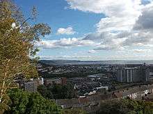
The district of Mayhill (also known as Mayhill Garden City) is spread over the top of a steep hill of the same name just north west of Swansea city centre, partly separated from Townhill to the west.
Mayhill Garden City started in 1914 as an experimental row of six houses that are still in occupation today as even numbers 2 to 12 Islwyn Road. The majority of homes were built by 1940.[1] Maps from 1874, 1879, and 1921 confirm that prior to the Mayhill Garden City project, Townhill Farm occupied the upper end of Waun Wen Road and a well used by Baptists was located halfway down. At the end of what is now called Long Ridge (previously called Bryon Crescent) there was, and still is, a Jewish burial ground. Waun Wen Road was completed before 1938.
Politically, Mayhill falls within the Townhill ward.[2] The south side of Mayhill overlooks the city centre, docklands and Swansea Bay. A prominent landmark on Mayhill, visible from the city centre and Hafod is Sea View Primary School (previously known as Mayhill Primary).
Mayhill consists mostly of suburban housing, however it does also feature a post office on Townhill Road, two fast food takeaways and a convenience store at the bottom of Waun Wen Road, as well as a small collection of shops at the intersection of Mayhill Road and Townhill Road. There are several churches in Mayhill including Our Lady of Lourdes, a popular Roman Catholic church, and Hill URC Church. Mayhill also features several park and nature reserve areas.
The largest open space recreational area is located around Sea View Primary School and includes parkland, small wooded areas, and heathland. There is also a small picnic park located along Bryn Y Don Road, and woodland between Waun Wen Road and Townhill Road.
The local football team is West End F.C. who play in Pryderi Park Stadium in the area.
References
- ↑ "The Planning of a Garden City Estate". City and County of Swansea.
- ↑ Townhill Ward Profile
Coordinates: 51°37′50.00″N 3°57′8.00″W / 51.6305556°N 3.9522222°W