Mokena, Illinois
| Village of Mokena | |
| Village | |
| Motto: Planned Progress, Pleasant Living | |
| Country | United States |
|---|---|
| State | Illinois |
| County | Will |
| River | Hickory Creek (Illinois) |
| Coordinates | 41°32′04″N 87°52′37″W / 41.534414°N 87.876873°WCoordinates: 41°32′04″N 87°52′37″W / 41.534414°N 87.876873°W |
| Area | 8.89 sq mi (23.02 km2) |
| - land | 8.89 sq mi (23 km2) |
| - water | 0.00 sq mi (0 km2), 0% |
| Population | 19,251 (2009) |
| Density | 2,432.4/sq mi (939.2/km2) |
| Incorporated | 1880 |
| Government | Village |
| Timezone | CST (UTC-6) |
| - summer (DST) | CDT (UTC-5) |
| Postal code | 60448 |
| Area code | 708 and 815/779 |
 Location in Will County and the state of Illinois. | |
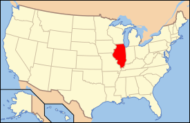
 Location of Illinois in the United States | |
| Website: http://www.mokena.org/ | |
Mokena is a village in Will County, Illinois, United States. The population was 14,583 at the 2000 census, with a special census conducted in 2007. The 2007 census showed that the population of the village increased to 18,669 people residing within the corporate limits. As of the 2010 Census the population was 18,740 people [1]
Mokena is a name derived from a Native American language meaning "turtle".[2]
Geography
Mokena is located at 41°32′4″N 87°52′37″W / 41.53444°N 87.87694°W.[3]
According to the 2010 census, Mokena has a total area of 8.893 square miles (23.03 km2), of which 8.89 square miles (23.02 km2) (or 99.97%) is land and 0.003 square miles (0.01 km2) (or 0.03%) is water.[4]
Education
Mokena is served by Lincoln-Way Community High School District 210, students attend Lincoln-Way East High School, Lincoln-Way Central High School, and Lincoln-Way North High School. Elementary school services are provided by one of four school districts: Mokena School District 159, New Lenox School District 122, Frankfort School District 157C, and Summit Hill School District 161. Schools within District 159 include MES (Mokena Elementary School), MIS (Mokena Intermediate School), and MJHS (Mokena Junior High School). Higher education is provided through Joliet Junior College, the nation's first public community college, and through Rasmussen College.
Demographics
| Historical population | |||
|---|---|---|---|
| Census | Pop. | %± | |
| 1880 | 522 | — | |
| 1890 | 364 | −30.3% | |
| 1900 | 281 | −22.8% | |
| 1910 | 359 | 27.8% | |
| 1920 | 475 | 32.3% | |
| 1930 | 562 | 18.3% | |
| 1940 | 657 | 16.9% | |
| 1950 | 903 | 37.4% | |
| 1960 | 1,332 | 47.5% | |
| 1970 | 1,643 | 23.3% | |
| 1980 | 4,578 | 178.6% | |
| 1990 | 6,128 | 33.9% | |
| 2000 | 14,583 | 138.0% | |
| 2010 | 18,740 | 28.5% | |
| Est. 2015 | 19,923 | [5] | 6.3% |
As of the census[7] of 2010, there were 18,740 people, 6,358 households, and 5,120 families residing in the village. The population density was 2,432.4 people per square mile (938.4/km²). There were 4,848 housing units at an average density of 808.6 per square mile (312.0/km²). The racial makeup of the village was 94.5% White, 1.3% African American, 0.01% Native American, 2.0% Asian, 0.01% Pacific Islander, 0.9% from other races, and 0.63% from two or more races. Hispanic or Latino of any race were 4.8% of the population.
As of the census of 2000, there were 4,703 households out of which 48.5% had children under the age of 18 living with them, 73.7% were married couples living together, 7.3% had a female householder with no husband present, and 16.8% were non-families. 14.0% of all households were made up of individuals and 3.3% had someone living alone who was 65 years of age or older. The average household size was 3.10 and the average family size was 3.46.
In the village the population was spread out with 32.4% under the age of 18, 7.1% from 18 to 24, 32.7% from 25 to 44, 21.5% from 45 to 64, and 6.2% who were 65 years of age or older. The median age was 34 years. For every 100 females there were 101.5 males. For every 100 females age 18 and over, there were 97.3 males.
The median family income is $82,596 and the median income for a household is $91,817. Males had a median income of $58,226 versus $31,522 for females. The per capita income for the village was $31,944. As of 2008, the median house value was $350,130, up from $211,300 in 2000.[8]
About 0.7% of families and 1.0% of the population were below the poverty line, including 0.6% of those under age 18 and 4.6% of those age 65 or over.
Transportation
The Village of Mokena is serviced by the Metra rail service Rock Island District. Two commuter rail stations are located within Mokena; Hickory Creek and Front Street, providing service to downtown Chicago's LaSalle Street Station, connecting with components of the Chicago Transit Authority. Mokena is also served by I-80, which runs along the northern border of the village. Through I-80, commuters have convenient access to I-355 (Veteran's Memorial Tollway) and to I-57. The main north-south thoroughfares are US Route 45 (LaGrange Rd) and Wolf Rd. The main east-west thoroughfares are 191st St, LaPorte Rd., and US Route 30 (Lincoln Highway). Rail freight traffic travels along both the Metra RI District Railway (Metra RI) and the Canadian National Railway (CN). The CN tracks run east/west along the southern boundary of Mokena, while the Metra Rock Island District (Metra) tracks approximately bisect the town running in a northeastern/southwestern direction.
Notable people
- Dean Anna, MLB player; born in Mokena
- James Augustine, former NBA player
- Terry Boers, sports radio host and Chicago Sun-Times columnist
- Karla DeVito, actress, voice actress, and singer; born in Mokena
- Clay Guida, mixed martial artists, Jason's brother
- Jason Guida, mixed martial artists, Clay's brother
- Don C. Hall, state actor and Wisconsin state legislator; lived in Mokena[9]
- Denise Richards, model and actress, lived in Mokena[10]
References
- ↑ http://www.census.gov/2010census/popmap/ipmtext.php?fl=17
- ↑ Gannett, Henry (1905). The Origin of Certain Place Names in the United States. U.S. Government Printing Office. p. 211.
- ↑ "US Gazetteer files: 2010, 2000, and 1990". United States Census Bureau. 2011-02-12. Retrieved 2011-04-23.
- ↑ "G001 - Geographic Identifiers - 2010 Census Summary File 1". United States Census Bureau. Retrieved 2015-12-19.
- ↑ "Annual Estimates of the Resident Population for Incorporated Places: April 1, 2010 to July 1, 2015". Retrieved July 2, 2016.
- ↑ "Census of Population and Housing". Census.gov. Retrieved June 4, 2015.
- ↑ "American FactFinder". United States Census Bureau. Retrieved 2008-01-31.
- ↑ http://www.city-data.com/city/Mokena-Illinois.html
- ↑ 'Don C. Hall, 87, Veteran Show Trouper, Dies,' Stevens Point Daily Journal, October 29, 1953, pg. 15
- ↑ http://www.dailyherald.com/article/20110830/news/708309985/
External links
- Mokena official website
- Mokena School District 159
- Frankfort School District 157C
- Summit Hill School District 161
- Wikimapia Contributions

