Mubarak Al-Kabeer Governorate
| Mubarak Al-Kabeer Governorate محافظة مبارك الكبير | |
|---|---|
| Governorate | |
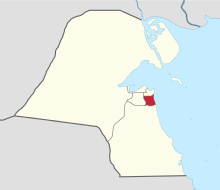
 Map of Kuwait with Mubarak Al-Kabeer highlighted | |
| Coordinates (Mubarak Al-Kabeer): 29°15′25″N 48°03′25″E / 29.257°N 48.057°ECoordinates: 29°15′25″N 48°03′25″E / 29.257°N 48.057°E | |
| Country |
|
| Capital | Mubarak Al-Kabeer |
| Districts | 8 |
| Area | |
| • Total | 100 km2 (40 sq mi) |
| Population (June 2014)[1] | |
| • Total | 230,727 |
| • Density | 2,300/km2 (6,000/sq mi) |
| Time zone | EAT (UTC+03) |
| ISO 3166 code | KW-MU |
Mubarak Al-Kabeer Governorate (Arabic: محافظة مبارك الكبير Muḥāfaẓat Mubārak al-Kabīr) is one of the governorates of Kuwait which mainly houses residential areas. It was formed in 2000 when the Hawalli Governorate was split in two.
References
 |
Hawalli Governorate |  | ||
| Al Farwaniyah Governorate | |
Persian Gulf | ||
| ||||
| | ||||
Template:Kuwait
This article is issued from Wikipedia - version of the 6/24/2016. The text is available under the Creative Commons Attribution/Share Alike but additional terms may apply for the media files.