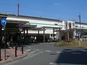
Niiza Station
Niiza Station 新座駅 | |
|---|---|
 South side of the station, March 2009 | |
| Location |
Nobitome 5-chome, Niiza-shi, Saitama-ken (埼玉県新座市野火止5丁目) Japan |
| Operated by |
|
| Line(s) | ■ Musashino Line |
| Platforms | 2 side platforms |
| Connections |
|
| History | |
| Opened | 1973 |
| Traffic | |
| Passengers (FY2013) | 19,431 daily |
Niiza Station (新座駅 Niiza-eki) is a railway station in Niiza, Saitama, Japan, operated by East Japan Railway Company (JR East).
Lines
Niiza Station is served by the orbital Musashino Line from Fuchū-Hommachi to Nishi-Funabashi and Tokyo. It is located 19.7 kilometers from Fuchū-Hommachi Station.
Station layout
The elevated station consists of two opposed side platforms serving two tracks, with the station building underneath. There is also a centre through-track for west-bound freight services accessing Niiza Freight Terminal to the west of the station.[1] The station has a Midori no Madoguchi staffed ticket office.
The Astro Boy theme tune is used as the departure melody.[2]
Platforms
| 1 | ■ Musashino Line | for Nishi-Kokubunji and Fuchū-Hommachi |
| 2 | ■ Musashino Line | for Musashi-Urawa, Shin-Matsudo, Nishi-Funabashi, Tokyo, and Kaihin-Makuhari |
Adjacent stations
| « | Service | » | ||
|---|---|---|---|---|
| Musashino Line | ||||
| Higashi-Tokorozawa | - | Kita-Asaka | ||
History
The station opened on 1 April 1973.[1]
Surrounding area
- Atomi University
- Jumonji University
- Rikkyo University Niiza Campus
- Rikkyo Niiza High School
- Niiza Freight Terminal (JR Freight)
- National Route 254
- National Route 463
See also
![]() Media related to Niiza Station at Wikimedia Commons
Media related to Niiza Station at Wikimedia Commons
References
- 1 2 Kawashima, Ryozo (February 2011). 日本の鉄道 中部ライン 全線・全駅・全配線 第11巻 埼玉南部・東京多摩北部 [Railways of Japan - Chubu Line - Lines/Stations/Track plans - Vol 11 Southern Saitama and Northern Tama Tokyo]. Japan: Kodansha. p. 22/59. ISBN 978-4-06-270071-9.
- ↑ 新座駅エリア街情報 [Niiza Station Area Town Information] (in Japanese). Japan: Fuji Ie. Retrieved 15 May 2011.
External links
- JR East station information (Japanese)
Coordinates: 35°48′13.7916″N 139°33′22.9″E / 35.803831000°N 139.556361°E